Rtishchevo elevation
Rtishchevo (Saratovskaya Oblast), Russia elevation is 210 meters and Rtishchevo elevation in feet is 689 ft above sea level [src 1]. Rtishchevo is a populated place (feature code) with elevation that is 11 meters (36 ft) bigger than average city elevation in Russia.
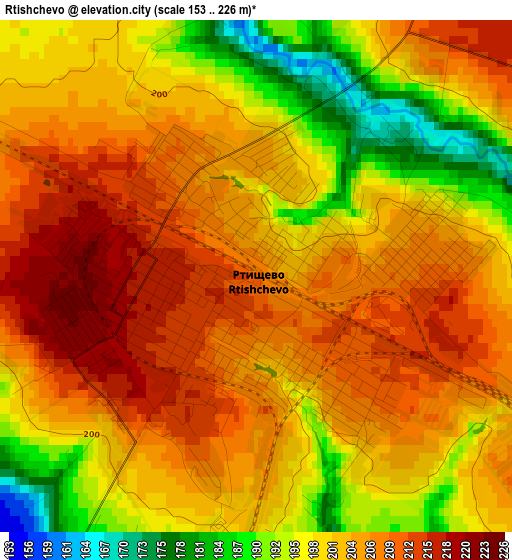
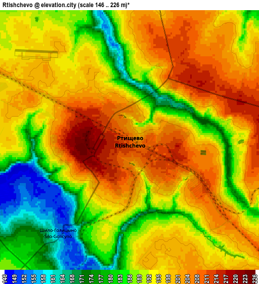
Below is the Elevation map of Rtishchevo, which displays elevation range with different colors. Scale of the first map is from 153 to 226 m (502 to 741 ft) with average elevation of 202.2 meters (=663 ft) [note 1]
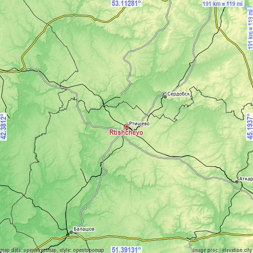
These maps also provides idea of topography and contour of this city, they are displayed at different zoom levels. More info about maps, scale and edge coordinates you can find below images.
| \ | Map #1 | Map #2 | Topo.Map |
| Scale [m] | 153..226 m | 146..226 m | × |
| Scale [ft] | 502..741 ft | 479..741 ft | × |
| Average | 202.2 m = 663 ft | 193.5 m = 635 ft | × |
| Width | 5.98 km = 3.7 mi | 11.96 km = 7.4 mi | 191.4 km = 118.9 mi |
| Height | 5.98 km = 3.7 mi | 11.96 km = 7.4 mi | 191.4 km = 118.9 mi |
| ↑Max Latitude | 52.2873° | 52.314173° | 53.11281° |
| Latitude at center | 52.26041° | 52.26041° | 52.26041° |
| ↓Min Latitude | 52.233504° | 52.206582° | 51.39131° |
| ← Min Longitude | 43.743505° | 43.699559° | 42.3812° |
| Longitude center | 43.78745° | 43.78745° | 43.78745° |
| →Max Longitude | 43.831395° | 43.875341° | 45.1937° |
Nearby cities:
Cities around Rtishchevo sort by population:
• Serdobsk elevation 191 m
36.6 km,  52°
52°
• Kirsanov 152 m
84.4 km,  301°
301°
• Arkadak 134 m
41.5 km,  208°
208°
• Belinskiy 189 m
82.2 km,  342°
342°
• Kolyshley 208 m
70.5 km, 46°
• Tamala 207 m
47.9 km,  310°
310°
• Turki 165 m
46.4 km,  229°
229°
• Bekovo 155 m
23.5 km,  347°
347°
• Yekaterinovka 222 m
44.6 km,  121°
121°
• Malaya Serdoba 183 m
82.3 km,  73°
73°
• Repnoye 115 m
85 km, 209°
• Lermontovo 217 m
81.9 km, 354°
Multilingual:
 En español:
Rtíshchevo elevación 210 m.
 En France:
Rtichtchevo élévation 210 m.
 Auf Deutsch:
Rtishchevo höhe über dem Meeresspiegel ist 210 m.

Sources and notes:
- [note 1] Map square and city borders are not equal. Map elevation data is calculated only from area inside that square.
- [src 1] Elevation data from geonames database provided with same terms of usage.
- [src 2] The elevation map of Rtishchevo is generated using elevation data from NASA's 3 arcsec (90m) resolution SRTM data.
- [src 3] Base (background) map © OpenStreetMap contributors tiles are generated by Geofabrik and OpenTopoMap.
Copyright & License:
This Rtishchevo Elevation Map is licensed under CC BY-SA. You may reuse any part from this page, if you give a proper credit by linking to this URL:
 More info on terms of use page.