Rzhanitsa elevation
Rzhanitsa (Bryansk Oblast), Russia elevation is 157 meters and Rzhanitsa elevation in feet is 515 ft above sea level [src 1]. Rzhanitsa is a populated place (feature code) with elevation that is 42 meters (138 ft) smaller than average city elevation in Russia.
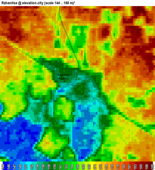
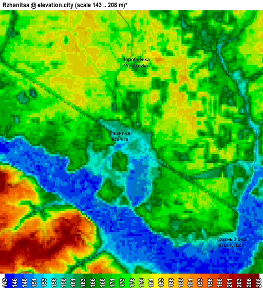
Below is the Elevation map of Rzhanitsa, which displays elevation range with different colors. Scale of the first map is from 144 to 188 m (472 to 617 ft) with average elevation of 167.2 meters (=549 ft) [note 1]
These maps also provides idea of topography and contour of this city, they are displayed at different zoom levels. More info about maps, scale and edge coordinates you can find below images.
| \ | Map #1 | Map #2 | Topo.Map |
| Scale [m] | 144..188 m | 143..208 m | × |
| Scale [ft] | 472..617 ft | 469..682 ft | × |
| Average | 167.2 m = 549 ft | 169.6 m = 556 ft | × |
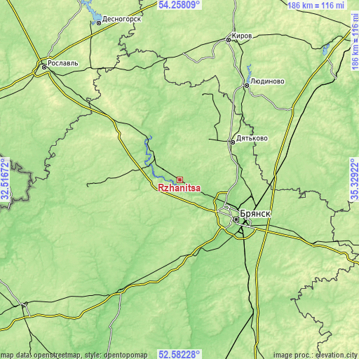
| Width | 5.82 km = 3.6 mi | 11.65 km = 7.2 mi | 186.3 km = 115.8 mi |
| Height | 5.82 km = 3.6 mi | 11.65 km = 7.2 mi | 186.3 km = 115.8 mi |
| ↑Max Latitude | 53.454616° | 53.480775° | 54.25809° |
| Latitude at center | 53.42844° | 53.42844° | 53.42844° |
| ↓Min Latitude | 53.402248° | 53.37604° | 52.58228° |
| ← Min Longitude | 33.879025° | 33.835079° | 32.51672° |
| Longitude center | 33.92297° | 33.92297° | 33.92297° |
| →Max Longitude | 33.966915° | 34.010861° | 35.32922° |
Nearby cities:
Cities around Rzhanitsa sort by population:
• Dyat’kovo elevation 206 m
33.3 km,  55°
55°
• Zhukovka 171 m
17.4 km,  312°
312°
• Sel’tso 157 m
13.7 km,  119°
119°
• Ivot 180 m
32.6 km,  32°
32°
• Lyubokhna 164 m
31.9 km,  74°
74°
• Star’ 183 m
26.5 km, 34°
• Glinishchevo 186 m
16.7 km,  145°
145°
• Putëvka 186 m
30.7 km,  127°
127°
• Raditsa-Krylovka 148 m
31.4 km,  113°
113°
• Zhiryatino 180 m
26.2 km,  209°
209°
• Net’inka 151 m
19.9 km, 116°
• Ivanovka 157 m
21.6 km, 114°
Multilingual:
 En español:
Rzhanitsa elevación 157 m.
 En France:
Rzhanitsa élévation 157 m.
 Auf Deutsch:
Rzhanitsa höhe über dem Meeresspiegel ist 157 m.

Sources and notes:
- [note 1] Map square and city borders are not equal. Map elevation data is calculated only from area inside that square.
- [src 1] Elevation data from geonames database provided with same terms of usage.
- [src 2] The elevation map of Rzhanitsa is generated using elevation data from NASA's 3 arcsec (90m) resolution SRTM data.
- [src 3] Base (background) map © OpenStreetMap contributors tiles are generated by Geofabrik and OpenTopoMap.
Copyright & License:
This Rzhanitsa Elevation Map is licensed under CC BY-SA. You may reuse any part from this page, if you give a proper credit by linking to this URL:
 More info on terms of use page.