Salmi elevation
Salmi (Karelia), Russia elevation is 8 meters and Salmi elevation in feet is 26 ft above sea level [src 1]. Salmi is a populated place (feature code) with elevation that is 191 meters (627 ft) smaller than average city elevation in Russia.
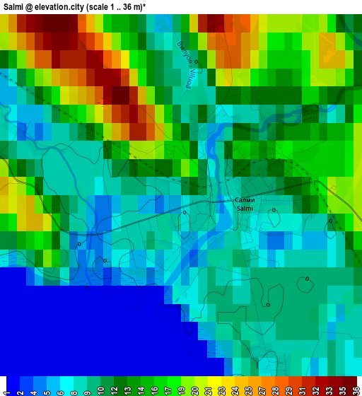
Below is the Elevation map of Salmi, which displays elevation range with different colors. Scale of the first map is from 1 to 36 m (3 to 118 ft) with average elevation of 11.7 meters (=38 ft) [note 1]
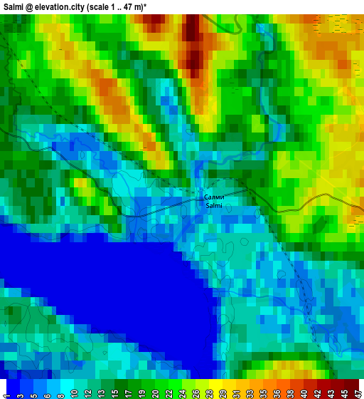
These maps also provides idea of topography and contour of this city, they are displayed at different zoom levels. More info about maps, scale and edge coordinates you can find below images.
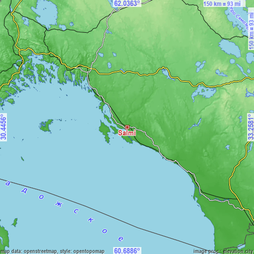
| \ | Map #1 | Map #2 | Topo.Map |
| Scale [m] | 1..36 m | 1..47 m | × |
| Scale [ft] | 3..118 ft | 3..154 ft | × |
| Average | 11.7 m = 38 ft | 15 m = 49 ft | × |
| Width | 4.68 km = 2.9 mi | 9.37 km = 5.8 mi | 149.9 km = 93.1 mi |
| Height | 4.68 km = 2.9 mi | 9.37 km = 5.8 mi | 149.8 km = 93.1 mi |
| ↑Max Latitude | 61.39076° | 61.411795° | 62.0363° |
| Latitude at center | 61.36971° | 61.36971° | 61.36971° |
| ↓Min Latitude | 61.348646° | 61.327568° | 60.6886° |
| ← Min Longitude | 31.807905° | 31.763959° | 30.4456° |
| Longitude center | 31.85185° | 31.85185° | 31.85185° |
| →Max Longitude | 31.895795° | 31.939741° | 33.2581° |
Nearby cities:
Cities around Salmi sort by population:
• Sortavala elevation 3 m
71.5 km,  302°
302°
• Priozërsk 7 m
99.3 km,  248°
248°
• Pitkyaranta 34 m
30.1 km,  318°
318°
• Suoyarvi 161 m
83.6 km,  18°
18°
• Olonets 15 m
73.6 km,  125°
125°
• Lakhdenpokh’ya 14 m
89.4 km,  280°
280°
• Lyaskelya 21 m
62.6 km,  314°
314°
• Essoyla 103 m
88.3 km,  50°
50°
• Kharlu 69 m
67.6 km, 315°
• Khelyulya 10 m
75.7 km, 303°
• Ruskeala 100 m
91.7 km, 313°
• Yanis’yarvi 85 m
75.1 km, 320°
Multilingual:
 En español:
Salmi elevación 8 m.
 En France:
Salmi élévation 8 m.


Sources and notes:
- [note 1] Map square and city borders are not equal. Map elevation data is calculated only from area inside that square.
- [src 1] Elevation data from geonames database provided with same terms of usage.
- [src 2] The elevation map of Salmi is generated using GMTED2010 database with 7.5 arcsec (225m) resolution.
- [src 3] Base (background) map © OpenStreetMap contributors tiles are generated by Geofabrik and OpenTopoMap.
Copyright & License:
This Salmi Elevation Map is licensed under CC BY-SA. You may reuse any part from this page, if you give a proper credit by linking to this URL:
 More info on terms of use page.