Sarov elevation
Sarov (Nizhny Novgorod Oblast), Russia elevation is 143 meters and Sarov elevation in feet is 469 ft above sea level [src 1]. Sarov is a populated place (feature code) with elevation that is 56 meters (184 ft) smaller than average city elevation in Russia.
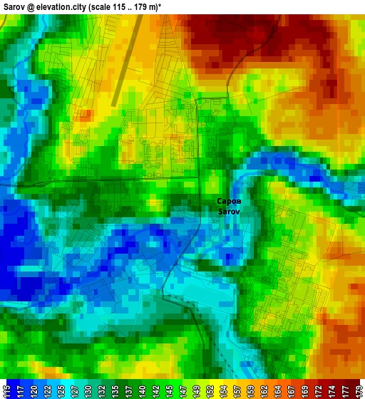
Below is the Elevation map of Sarov, which displays elevation range with different colors. Scale of the first map is from 115 to 179 m (377 to 587 ft) with average elevation of 143.2 meters (=470 ft) [note 1]
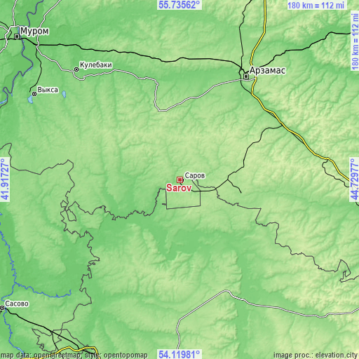
These maps also provides idea of topography and contour of this city, they are displayed at different zoom levels. More info about maps, scale and edge coordinates you can find below images.
| \ | Map #1 | Map #2 | Topo.Map |
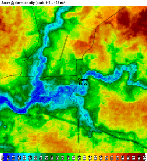
| Scale [m] | 115..179 m | 113..192 m | × |
| Scale [ft] | 377..587 ft | 371..630 ft | × |
| Average | 143.2 m = 470 ft | 152.5 m = 500 ft | × |
| Width | 5.61 km = 3.5 mi | 11.23 km = 7 mi | 179.7 km = 111.7 mi |
| Height | 5.61 km = 3.5 mi | 11.23 km = 7 mi | 179.6 km = 111.6 mi |
| ↑Max Latitude | 54.961068° | 54.986291° | 55.73562° |
| Latitude at center | 54.93583° | 54.93583° | 54.93583° |
| ↓Min Latitude | 54.910576° | 54.885306° | 54.11981° |
| ← Min Longitude | 43.279575° | 43.235629° | 41.91727° |
| Longitude center | 43.32352° | 43.32352° | 43.32352° |
| →Max Longitude | 43.367465° | 43.411411° | 44.72977° |
Nearby cities:
Cities around Sarov sort by population:
• Pervomaysk elevation 160 m
31.5 km,  103°
103°
• Ardatov 155 m
37 km,  337°
337°
• Temnikov 124 m
34.7 km,  191°
191°
• Vyyezdnoye 119 m
57.6 km,  30°
30°
• Diveyevo 151 m
13 km, 336°
• Voznesenskoye 113 m
36.6 km,  261°
261°
• Gremyachevo 115 m
54.1 km, 339°
• Ten’gushevo 113 m
42.9 km,  244°
244°
• Barashevo 148 m
53.1 km,  212°
212°
• Sosnovka 139 m
25 km,  183°
183°
• Satis 122 m
6.2 km, 256°
• Satis 180 m
32.8 km,  72°
72°
Multilingual:
 En español:
Sarov elevación 143 m.
 En France:
Sarov élévation 143 m.


Sources and notes:
- [note 1] Map square and city borders are not equal. Map elevation data is calculated only from area inside that square.
- [src 1] Elevation data from geonames database provided with same terms of usage.
- [src 2] The elevation map of Sarov is generated using elevation data from NASA's 3 arcsec (90m) resolution SRTM data.
- [src 3] Base (background) map © OpenStreetMap contributors tiles are generated by Geofabrik and OpenTopoMap.
Copyright & License:
This Sarov Elevation Map is licensed under CC BY-SA. You may reuse any part from this page, if you give a proper credit by linking to this URL:
 More info on terms of use page.