Sars elevation
Sars (Perm), Russia elevation is 311 meters and Sars elevation in feet is 1020 ft above sea level [src 1]. Sars is a populated place (feature code) with elevation that is 112 meters (367 ft) bigger than average city elevation in Russia.
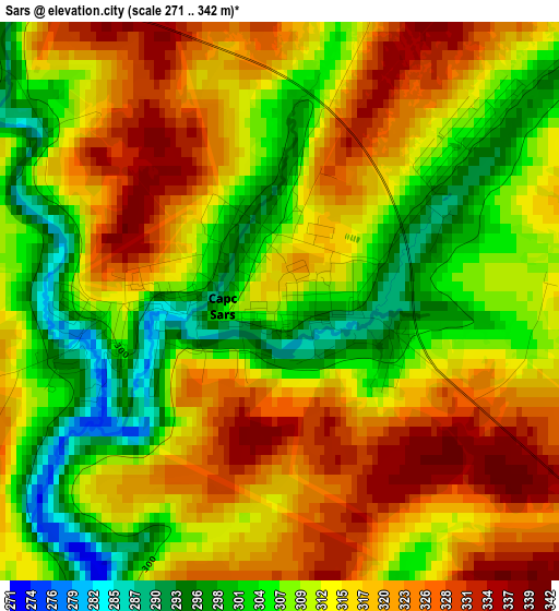
Below is the Elevation map of Sars, which displays elevation range with different colors. Scale of the first map is from 271 to 342 m (889 to 1122 ft) with average elevation of 313.3 meters (=1028 ft) [note 1]
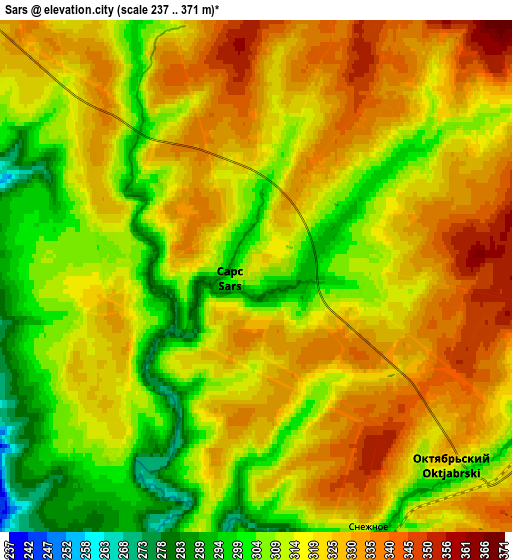
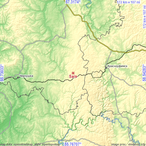
These maps also provides idea of topography and contour of this city, they are displayed at different zoom levels. More info about maps, scale and edge coordinates you can find below images.
| \ | Map #1 | Map #2 | Topo.Map |
| Scale [m] | 271..342 m | 237..371 m | × |
| Scale [ft] | 889..1122 ft | 778..1217 ft | × |
| Average | 313.3 m = 1028 ft | 318 m = 1043 ft | × |
| Width | 5.39 km = 3.3 mi | 10.77 km = 6.7 mi | 172.4 km = 107.1 mi |
| Height | 5.39 km = 3.3 mi | 10.77 km = 6.7 mi | 172.4 km = 107.1 mi |
| ↑Max Latitude | 56.574385° | 56.598585° | 57.3174° |
| Latitude at center | 56.55017° | 56.55017° | 56.55017° |
| ↓Min Latitude | 56.525939° | 56.501693° | 55.76707° |
| ← Min Longitude | 57.092635° | 57.048689° | 55.73033° |
| Longitude center | 57.13658° | 57.13658° | 57.13658° |
| →Max Longitude | 57.180525° | 57.224471° | 58.54283° |
Nearby cities:
Cities around Sars sort by population:
• Krasnoufimsk elevation 206 m
39.1 km,  80°
80°
• Chernushka 141 m
65.2 km,  265°
265°
• Suksun 188 m
67.8 km,  13°
13°
• Askino 169 m
61.7 km,  213°
213°
• Verkhniye Tatyshly 159 m
83.8 km,  249°
249°
• Orda 152 m
73 km,  349°
349°
• Karaidel’ 206 m
80.9 km,  190°
190°
• Achit 233 m
54.2 km,  59°
59°
• Uinskoye 165 m
50.1 km,  317°
317°
• Ufimskiy 223 m
58.7 km,  72°
72°
• Sarana 195 m
37 km,  102°
102°
• Nizhnyaya Irga 212 m
39.3 km,  26°
26°
Multilingual:
 En español:
Sars elevación 311 m.
 En France:
Sars élévation 311 m.


Sources and notes:
- [note 1] Map square and city borders are not equal. Map elevation data is calculated only from area inside that square.
- [src 1] Elevation data from geonames database provided with same terms of usage.
- [src 2] The elevation map of Sars is generated using elevation data from NASA's 3 arcsec (90m) resolution SRTM data.
- [src 3] Base (background) map © OpenStreetMap contributors tiles are generated by Geofabrik and OpenTopoMap.
Copyright & License:
This Sars Elevation Map is licensed under CC BY-SA. You may reuse any part from this page, if you give a proper credit by linking to this URL:
 More info on terms of use page.