Semibratovo elevation
Semibratovo (Jaroslavl), Russia elevation is 101 meters and Semibratovo elevation in feet is 331 ft above sea level [src 1]. Semibratovo is a populated place (feature code) with elevation that is 98 meters (322 ft) smaller than average city elevation in Russia.
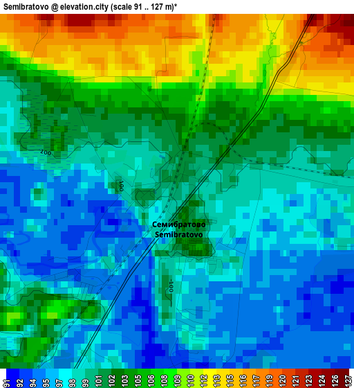
Below is the Elevation map of Semibratovo, which displays elevation range with different colors. Scale of the first map is from 91 to 127 m (299 to 417 ft) with average elevation of 101.6 meters (=333 ft) [note 1]
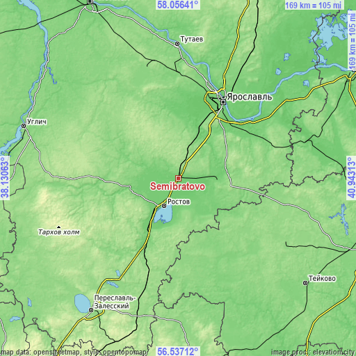
These maps also provides idea of topography and contour of this city, they are displayed at different zoom levels. More info about maps, scale and edge coordinates you can find below images.
| \ | Map #1 | Map #2 | Topo.Map |
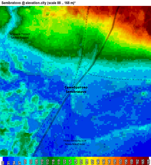
| Scale [m] | 91..127 m | 88..168 m | × |
| Scale [ft] | 299..417 ft | 289..551 ft | × |
| Average | 101.6 m = 333 ft | 108.3 m = 355 ft | × |
| Width | 5.28 km = 3.3 mi | 10.56 km = 6.6 mi | 168.9 km = 104.9 mi |
| Height | 5.28 km = 3.3 mi | 10.56 km = 6.6 mi | 168.9 km = 104.9 mi |
| ↑Max Latitude | 57.32834° | 57.352055° | 58.05641° |
| Latitude at center | 57.30461° | 57.30461° | 57.30461° |
| ↓Min Latitude | 57.280864° | 57.257103° | 56.53712° |
| ← Min Longitude | 39.492935° | 39.448989° | 38.13063° |
| Longitude center | 39.53688° | 39.53688° | 39.53688° |
| →Max Longitude | 39.580825° | 39.624771° | 40.94313° |
Nearby cities:
Cities around Semibratovo sort by population:
• Yaroslavl elevation 103 m
41.4 km,  29°
29°
• Rostov 100 m
14.6 km,  210°
210°
• Gavrilov-Yam 103 m
19 km,  90°
90°
• Borisoglebskiy 120 m
23.8 km,  257°
257°
• Petrovsk 135 m
36.5 km, 206°
• Krasnyye Tkachi 104 m
24.7 km, 32°
• Il’inskoye-Khovanskoye 150 m
39.6 km,  159°
159°
• Dubki 141 m
42.8 km, 90°
• Burmakino 130 m
43.8 km,  73°
73°
• Ishnya 98 m
16.5 km,  220°
220°
• Porech’ye-Rybnoye 97 m
24.8 km,  201°
201°
• Kurba 145 m
28.6 km,  355°
355°
Multilingual:
 En español:
Semibratovo elevación 101 m.
 En France:
Semibratovo élévation 101 m.
 Auf Deutsch:
Semibratovo höhe über dem Meeresspiegel ist 101 m.

Sources and notes:
- [note 1] Map square and city borders are not equal. Map elevation data is calculated only from area inside that square.
- [src 1] Elevation data from geonames database provided with same terms of usage.
- [src 2] The elevation map of Semibratovo is generated using elevation data from NASA's 3 arcsec (90m) resolution SRTM data.
- [src 3] Base (background) map © OpenStreetMap contributors tiles are generated by Geofabrik and OpenTopoMap.
Copyright & License:
This Semibratovo Elevation Map is licensed under CC BY-SA. You may reuse any part from this page, if you give a proper credit by linking to this URL:
 More info on terms of use page.