Semiluki elevation
Semiluki (Voronezj), Russia elevation is 118 meters and Semiluki elevation in feet is 387 ft above sea level [src 1]. Semiluki is a populated place (feature code) with elevation that is 81 meters (266 ft) smaller than average city elevation in Russia.
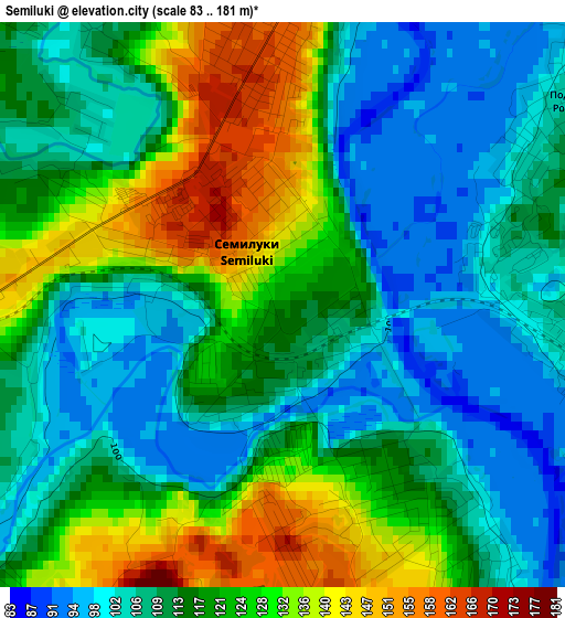
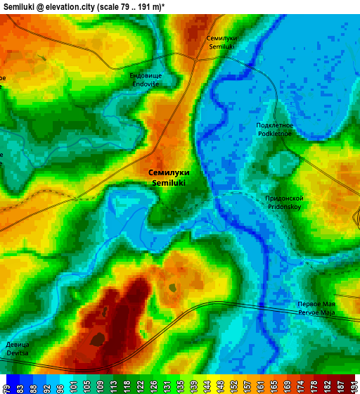
Below is the Elevation map of Semiluki, which displays elevation range with different colors. Scale of the first map is from 83 to 181 m (272 to 594 ft) with average elevation of 116.1 meters (=381 ft) [note 1]
These maps also provides idea of topography and contour of this city, they are displayed at different zoom levels. More info about maps, scale and edge coordinates you can find below images.
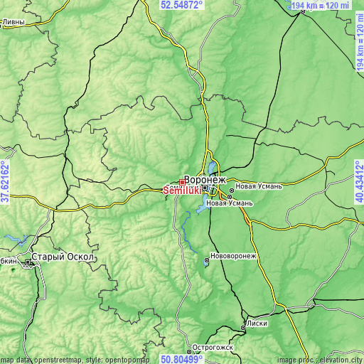
| \ | Map #1 | Map #2 | Topo.Map |
| Scale [m] | 83..181 m | 79..191 m | × |
| Scale [ft] | 272..594 ft | 259..627 ft | × |
| Average | 116.1 m = 381 ft | 123.8 m = 406 ft | × |
| Width | 6.06 km = 3.8 mi | 12.12 km = 7.5 mi | 193.9 km = 120.5 mi |
| Height | 6.06 km = 3.8 mi | 12.12 km = 7.5 mi | 193.9 km = 120.5 mi |
| ↑Max Latitude | 51.712487° | 51.739708° | 52.54872° |
| Latitude at center | 51.68525° | 51.68525° | 51.68525° |
| ↓Min Latitude | 51.657997° | 51.630727° | 50.80499° |
| ← Min Longitude | 38.983925° | 38.939979° | 37.62162° |
| Longitude center | 39.02787° | 39.02787° | 39.02787° |
| →Max Longitude | 39.071815° | 39.115761° | 40.43412° |
Nearby cities:
Cities around Semiluki sort by population:
• Voronezh elevation 156 m
10.9 km,  97°
97°
• Novaya Usman’ 103 m
26.7 km, 100°
• Pridonskoy 110 m
3.1 km,  92°
92°
• Somovo 110 m
24.1 km,  75°
75°
• Podgornoye 134 m
10 km,  56°
56°
• Maslovka 110 m
20.5 km,  135°
135°
• Latnaya 163 m
9.2 km,  251°
251°
• Shilovo 90 m
16.1 km,  164°
164°
• Strelitsa 120 m
11.8 km,  223°
223°
• Devitsa 111 m
8 km,  225°
225°
• Zemlyansk 186 m
31.7 km,  320°
320°
• Novozhivotinnoye 113 m
24.5 km,  23°
23°
Multilingual:
 En español:
Semiluki elevación 118 m.
 En France:
Semilouki élévation 118 m.
 Auf Deutsch:
Semiluki höhe über dem Meeresspiegel ist 118 m.

Sources and notes:
- [note 1] Map square and city borders are not equal. Map elevation data is calculated only from area inside that square.
- [src 1] Elevation data from geonames database provided with same terms of usage.
- [src 2] The elevation map of Semiluki is generated using elevation data from NASA's 3 arcsec (90m) resolution SRTM data.
- [src 3] Base (background) map © OpenStreetMap contributors tiles are generated by Geofabrik and OpenTopoMap.
Copyright & License:
This Semiluki Elevation Map is licensed under CC BY-SA. You may reuse any part from this page, if you give a proper credit by linking to this URL:
 More info on terms of use page.