Serpukhov elevation
Serpukhov (Moscow Oblast), Russia elevation is 138 meters and Serpukhov elevation in feet is 453 ft above sea level [src 1]. Serpukhov is a populated place (feature code) with elevation that is 61 meters (200 ft) smaller than average city elevation in Russia.
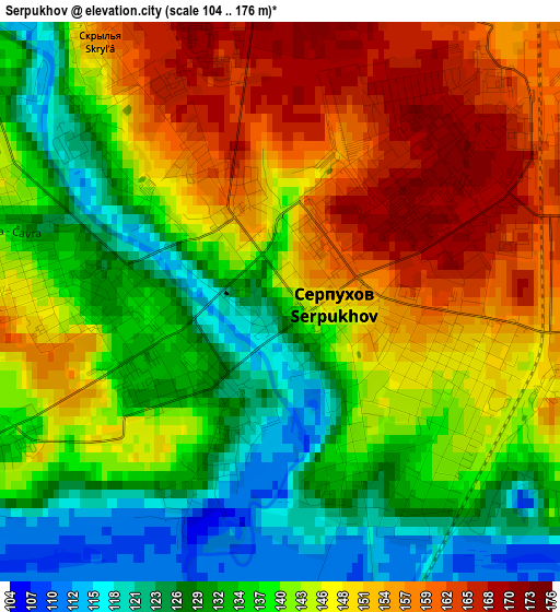
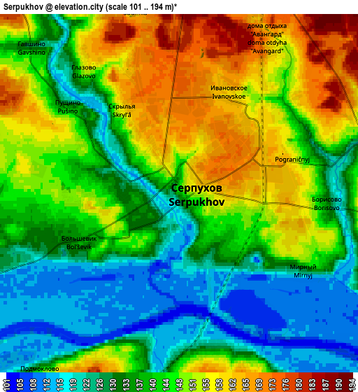
Below is the Elevation map of Serpukhov, which displays elevation range with different colors. Scale of the first map is from 104 to 176 m (341 to 577 ft) with average elevation of 142 meters (=466 ft) [note 1]
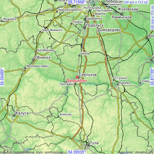
These maps also provides idea of topography and contour of this city, they are displayed at different zoom levels. More info about maps, scale and edge coordinates you can find below images.
| \ | Map #1 | Map #2 | Topo.Map |
| Scale [m] | 104..176 m | 101..194 m | × |
| Scale [ft] | 341..577 ft | 331..636 ft | × |
| Average | 142 m = 466 ft | 141.5 m = 464 ft | × |
| Width | 5.62 km = 3.5 mi | 11.23 km = 7 mi | 179.8 km = 111.7 mi |
| Height | 5.62 km = 3.5 mi | 11.23 km = 7 mi | 179.7 km = 111.7 mi |
| ↑Max Latitude | 54.941031° | 54.966266° | 55.71598° |
| Latitude at center | 54.91578° | 54.91578° | 54.91578° |
| ↓Min Latitude | 54.890513° | 54.865231° | 54.09935° |
| ← Min Longitude | 37.367195° | 37.323249° | 36.00489° |
| Longitude center | 37.41114° | 37.41114° | 37.41114° |
| →Max Longitude | 37.455085° | 37.499031° | 38.81739° |
Nearby cities:
Cities around Serpukhov sort by population:
• Chekhov elevation 174 m
26.1 km,  9°
9°
• Protvino 134 m
13.6 km,  247°
247°
• Pushchino 191 m
15.7 km,  125°
125°
• Kremenki 133 m
18.9 km,  260°
260°
• Tarusa 165 m
26.2 km,  215°
215°
• Zaokskiy 236 m
20.4 km,  181°
181°
• Obolensk 179 m
13.7 km,  299°
299°
• Proletarskiy 165 m
11.9 km,  353°
353°
• Novyy Byt 179 m
20.5 km,  39°
39°
• Popovo 137 m
24.1 km, 42°
• Bol’shoye Gryzlovo 204 m
19.4 km, 131°
• Danki 168 m
10.2 km,  88°
88°
Multilingual:
 En español:
Serpukhov elevación 138 m.
 En France:
Serpukhov élévation 138 m.
 Auf Deutsch:
Serpuchow höhe über dem Meeresspiegel ist 138 m.

Sources and notes:
- [note 1] Map square and city borders are not equal. Map elevation data is calculated only from area inside that square.
- [src 1] Elevation data from geonames database provided with same terms of usage.
- [src 2] The elevation map of Serpukhov is generated using elevation data from NASA's 3 arcsec (90m) resolution SRTM data.
- [src 3] Base (background) map © OpenStreetMap contributors tiles are generated by Geofabrik and OpenTopoMap.
Copyright & License:
This Serpukhov Elevation Map is licensed under CC BY-SA. You may reuse any part from this page, if you give a proper credit by linking to this URL:
 More info on terms of use page.