Shenkursk elevation
Shenkursk (Arkhangelskaya), Russia elevation is 55 meters and Shenkursk elevation in feet is 180 ft above sea level [src 1]. Shenkursk is a populated place (feature code) with elevation that is 144 meters (472 ft) smaller than average city elevation in Russia.
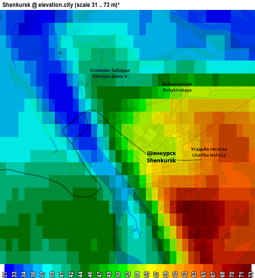
Below is the Elevation map of Shenkursk, which displays elevation range with different colors. Scale of the first map is from 31 to 73 m (102 to 240 ft) with average elevation of 46.1 meters (=151 ft) [note 1]
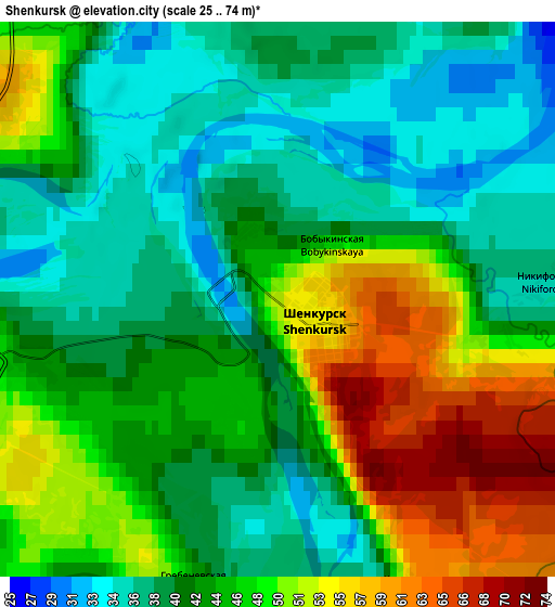
These maps also provides idea of topography and contour of this city, they are displayed at different zoom levels. More info about maps, scale and edge coordinates you can find below images.
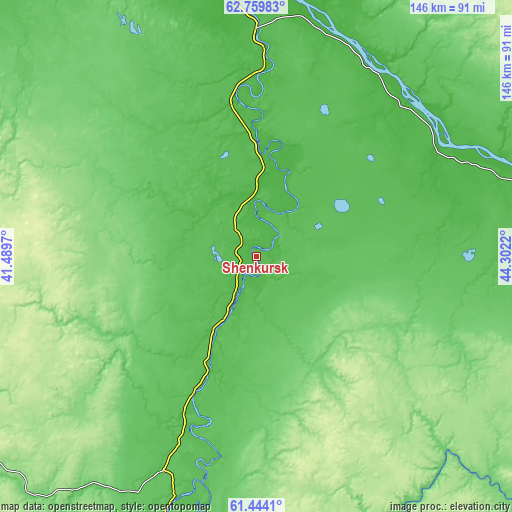
| \ | Map #1 | Map #2 | Topo.Map |
| Scale [m] | 31..73 m | 25..74 m | × |
| Scale [ft] | 102..240 ft | 82..243 ft | × |
| Average | 46.1 m = 151 ft | 44.2 m = 145 ft | × |
| Width | 4.57 km = 2.8 mi | 9.14 km = 5.7 mi | 146.3 km = 90.9 mi |
| Height | 4.57 km = 2.8 mi | 9.14 km = 5.7 mi | 146.3 km = 90.9 mi |
| ↑Max Latitude | 62.12965° | 62.150186° | 62.75983° |
| Latitude at center | 62.1091° | 62.1091° | 62.1091° |
| ↓Min Latitude | 62.088536° | 62.067958° | 61.4441° |
| ← Min Longitude | 42.852005° | 42.808059° | 41.4897° |
| Longitude center | 42.89595° | 42.89595° | 42.89595° |
| →Max Longitude | 42.939895° | 42.983841° | 44.3022° |
Nearby cities:
Cities around Shenkursk sort by population:
• Mirnyy elevation 110 m
122.1 km,  134°
134°
• Vel’sk 94 m
123 km,  200°
200°
• Kuloy 107 m
121.8 km,  190°
190°
• Berëznik 15 m
83.2 km,  353°
353°
• Verkhnyaya Toyma 65 m
110.1 km,  82°
82°
• Dvinskoy 62 m
115.6 km,  87°
87°
• Shalakusha 73 m
137.8 km,  275°
275°
• Rochegda 29 m
67.6 km,  23°
23°
• Ust’-Shonosha 103 m
134.3 km,  217°
217°
• Shangaly 63 m
111.5 km,  168°
168°
• Puksoozero 177 m
129.7 km,  294°
294°
• Ileza 181 m
128.9 km,  155°
155°
Multilingual:
 En español:
Shénkursk elevación 55 m.
 En France:
Chenkoursk élévation 55 m.
 Auf Deutsch:
Schenkursk höhe über dem Meeresspiegel ist 55 m.

Sources and notes:
- [note 1] Map square and city borders are not equal. Map elevation data is calculated only from area inside that square.
- [src 1] Elevation data from geonames database provided with same terms of usage.
- [src 2] The elevation map of Shenkursk is generated using GMTED2010 database with 7.5 arcsec (225m) resolution.
- [src 3] Base (background) map © OpenStreetMap contributors tiles are generated by Geofabrik and OpenTopoMap.
Copyright & License:
This Shenkursk Elevation Map is licensed under CC BY-SA. You may reuse any part from this page, if you give a proper credit by linking to this URL:
 More info on terms of use page.