Shuya elevation
Shuya (Ivanovo), Russia elevation is 105 meters and Shuya elevation in feet is 344 ft above sea level [src 1]. Shuya is a populated place (feature code) with elevation that is 94 meters (308 ft) smaller than average city elevation in Russia.
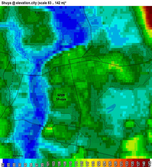
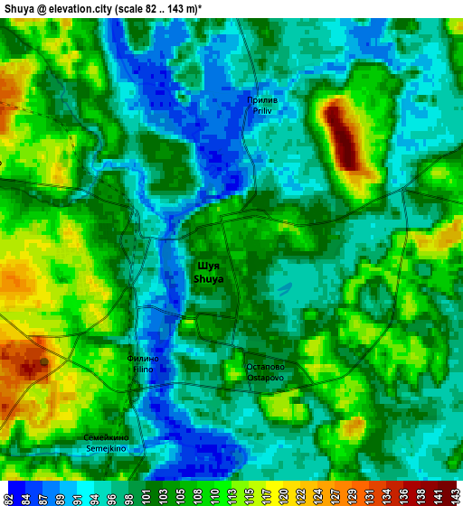
Below is the Elevation map of Shuya, which displays elevation range with different colors. Scale of the first map is from 83 to 142 m (272 to 466 ft) with average elevation of 98.9 meters (=324 ft) [note 1]
These maps also provides idea of topography and contour of this city, they are displayed at different zoom levels. More info about maps, scale and edge coordinates you can find below images.
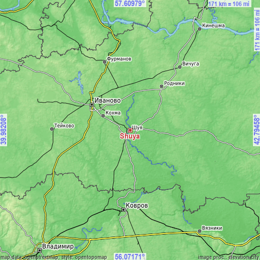
| \ | Map #1 | Map #2 | Topo.Map |
| Scale [m] | 83..142 m | 82..143 m | × |
| Scale [ft] | 272..466 ft | 269..469 ft | × |
| Average | 98.9 m = 324 ft | 102.3 m = 336 ft | × |
| Width | 5.34 km = 3.3 mi | 10.69 km = 6.6 mi | 171 km = 106.3 mi |
| Height | 5.34 km = 3.3 mi | 10.69 km = 6.6 mi | 171 km = 106.3 mi |
| ↑Max Latitude | 56.872674° | 56.896682° | 57.60979° |
| Latitude at center | 56.84865° | 56.84865° | 56.84865° |
| ↓Min Latitude | 56.824611° | 56.800556° | 56.07171° |
| ← Min Longitude | 41.344385° | 41.300439° | 39.98208° |
| Longitude center | 41.38833° | 41.38833° | 41.38833° |
| →Max Longitude | 41.432275° | 41.476221° | 42.79458° |
Nearby cities:
Cities around Shuya sort by population:
• Ivanovo elevation 126 m
30.2 km,  303°
303°
• Kokhma 120 m
20.4 km, 298°
• Rodniki 147 m
35.3 km,  36°
36°
• Lezhnevo 108 m
31.3 km,  254°
254°
• Savino 112 m
30.3 km,  200°
200°
• Palekh 120 m
28.9 km,  100°
100°
• Bogorodskoye 125 m
31.7 km,  314°
314°
• Kitovo 114 m
6.7 km,  286°
286°
• Kolobovo 109 m
16.6 km,  189°
189°
• Novyye Gorki 97 m
24.2 km,  235°
235°
• Arkhipovka 105 m
22.2 km, 201°
• Kaminskiy 116 m
34.1 km,  8°
8°
Multilingual:
 En español:
Shuya elevación 105 m.
 En France:
Chouïa élévation 105 m.


Sources and notes:
- [note 1] Map square and city borders are not equal. Map elevation data is calculated only from area inside that square.
- [src 1] Elevation data from geonames database provided with same terms of usage.
- [src 2] The elevation map of Shuya is generated using elevation data from NASA's 3 arcsec (90m) resolution SRTM data.
- [src 3] Base (background) map © OpenStreetMap contributors tiles are generated by Geofabrik and OpenTopoMap.
Copyright & License:
This Shuya Elevation Map is licensed under CC BY-SA. You may reuse any part from this page, if you give a proper credit by linking to this URL:
 More info on terms of use page.