Kashkhatau elevation
Kashkhatau (Kabardino-Balkariya Republic), Russia elevation is 696 meters and Kashkhatau elevation in feet is 2283 ft above sea level [src 1]. Kashkhatau is a populated place (feature code) with elevation that is 497 meters (1631 ft) bigger than average city elevation in Russia.
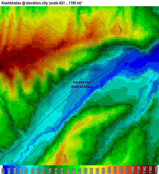
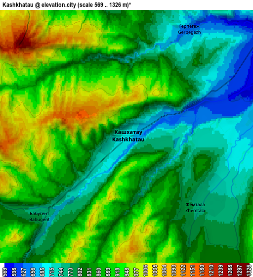
Below is the Elevation map of Kashkhatau, which displays elevation range with different colors. Scale of the first map is from 621 to 1185 m (2037 to 3888 ft) with average elevation of 858.8 meters (=2818 ft) [note 1]
These maps also provides idea of topography and contour of this city, they are displayed at different zoom levels. More info about maps, scale and edge coordinates you can find below images.
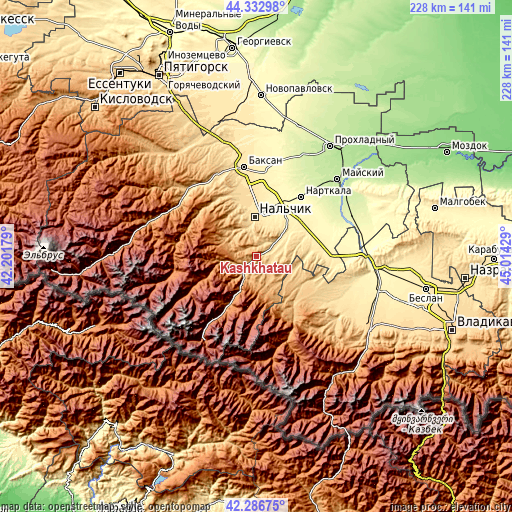
| \ | Map #1 | Map #2 | Topo.Map |
| Scale [m] | 621..1185 m | 569..1326 m | × |
| Scale [ft] | 2037..3888 ft | 1867..4350 ft | × |
| Average | 858.8 m = 2818 ft | 856.6 m = 2810 ft | × |
| Width | 7.11 km = 4.4 mi | 14.22 km = 8.8 mi | 227.5 km = 141.4 mi |
| Height | 7.11 km = 4.4 mi | 14.22 km = 8.8 mi | 227.5 km = 141.4 mi |
| ↑Max Latitude | 43.350444° | 43.382391° | 44.33298° |
| Latitude at center | 43.31848° | 43.31848° | 43.31848° |
| ↓Min Latitude | 43.286499° | 43.254501° | 42.28675° |
| ← Min Longitude | 43.564095° | 43.520149° | 42.20179° |
| Longitude center | 43.60804° | 43.60804° | 43.60804° |
| →Max Longitude | 43.651985° | 43.695931° | 45.01429° |
Nearby cities:
Cities around Kashkhatau sort by population:
• Nal’chik elevation 464 m
20 km,  2°
2°
• Nartan 386 m
22.6 km,  19°
19°
• Shalushka 493 m
24 km,  351°
351°
• Kenzhe 517 m
20.8 km, 348°
• Psygansu 474 m
18.7 km,  53°
53°
• Urvan’ 369 m
22.9 km,  32°
32°
• Vol’nyy Aul 472 m
17.9 km,  5°
5°
• Aushiger 566 m
13.2 km, 49°
• Aleksandrovskaya 450 m
18.6 km, 10°
• Belaya Rechka 715 m
14.5 km,  336°
336°
• Zhemtala 771 m
5.4 km,  134°
134°
• Babugent 768 m
6.4 km,  227°
227°
Multilingual:
 En español:
Kashkhatau elevación 696 m.
 En France:
Kashkhatau élévation 696 m.
 Auf Deutsch:
Kashkhatau höhe über dem Meeresspiegel ist 696 m.

Sources and notes:
- [note 1] Map square and city borders are not equal. Map elevation data is calculated only from area inside that square.
- [src 1] Elevation data from geonames database provided with same terms of usage.
- [src 2] The elevation map of Kashkhatau is generated using elevation data from NASA's 3 arcsec (90m) resolution SRTM data.
- [src 3] Base (background) map © OpenStreetMap contributors tiles are generated by Geofabrik and OpenTopoMap.
Copyright & License:
This Kashkhatau Elevation Map is licensed under CC BY-SA. You may reuse any part from this page, if you give a proper credit by linking to this URL:
 More info on terms of use page.