Tikhvin elevation
Tikhvin (Leningradskaya Oblast'), Russia elevation is 53 meters and Tikhvin elevation in feet is 174 ft above sea level [src 1]. Tikhvin is a populated place (feature code) with elevation that is 146 meters (479 ft) smaller than average city elevation in Russia.
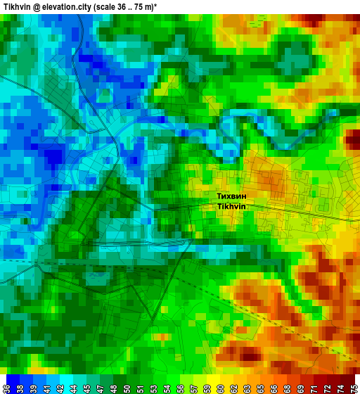
Below is the Elevation map of Tikhvin, which displays elevation range with different colors. Scale of the first map is from 36 to 75 m (118 to 246 ft) with average elevation of 51.3 meters (=168 ft) [note 1]
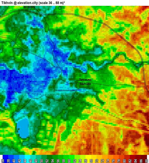
These maps also provides idea of topography and contour of this city, they are displayed at different zoom levels. More info about maps, scale and edge coordinates you can find below images.
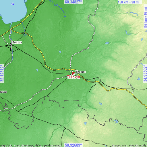
| \ | Map #1 | Map #2 | Topo.Map |
| Scale [m] | 36..75 m | 36..88 m | × |
| Scale [ft] | 118..246 ft | 118..289 ft | × |
| Average | 51.3 m = 168 ft | 58.9 m = 193 ft | × |
| Width | 4.94 km = 3.1 mi | 9.88 km = 6.1 mi | 158 km = 98.2 mi |
| Height | 4.94 km = 3.1 mi | 9.88 km = 6.1 mi | 158 km = 98.2 mi |
| ↑Max Latitude | 59.667311° | 59.689497° | 60.34827° |
| Latitude at center | 59.64511° | 59.64511° | 59.64511° |
| ↓Min Latitude | 59.622895° | 59.600665° | 58.92689° |
| ← Min Longitude | 33.485425° | 33.441479° | 32.12312° |
| Longitude center | 33.52937° | 33.52937° | 33.52937° |
| →Max Longitude | 33.573315° | 33.617261° | 34.93562° |
Nearby cities:
Cities around Tikhvin sort by population:
• Volkhov elevation 35 m
73.6 km,  295°
295°
• Pikalëvo 184 m
38.5 km,  111°
111°
• Boksitogorsk 102 m
26.2 km,  136°
136°
• Syas’stroy 9 m
76.5 km,  315°
315°
• Kholm 60 m
57 km,  222°
222°
• Budogoshch’ 52 m
72.2 km,  235°
235°
• Yefimovskiy 178 m
66.4 km,  104°
104°
• Kolchanovo 29 m
66.9 km,  308°
308°
• Nebolchi 115 m
58.9 km,  190°
190°
• Staraya Ladoga 16 m
79.5 km, 299°
• Khvalovo 34 m
55.6 km, 307°
• Issad 15 m
81.2 km, 305°
Multilingual:
 En español:
Tijvin elevación 53 m.
 En France:
Tikhvine élévation 53 m.


Sources and notes:
- [note 1] Map square and city borders are not equal. Map elevation data is calculated only from area inside that square.
- [src 1] Elevation data from geonames database provided with same terms of usage.
- [src 2] The elevation map of Tikhvin is generated using elevation data from NASA's 3 arcsec (90m) resolution SRTM data.
- [src 3] Base (background) map © OpenStreetMap contributors tiles are generated by Geofabrik and OpenTopoMap.
Copyright & License:
This Tikhvin Elevation Map is licensed under CC BY-SA. You may reuse any part from this page, if you give a proper credit by linking to this URL:
 More info on terms of use page.