Tlyustenkhabl’ elevation
Tlyustenkhabl’ (Adygeya Republic), Russia elevation is 22 meters and Tlyustenkhabl’ elevation in feet is 72 ft above sea level [src 1]. Tlyustenkhabl’ is a section of populated place (feature code) with elevation that is 177 meters (581 ft) smaller than average city elevation in Russia.
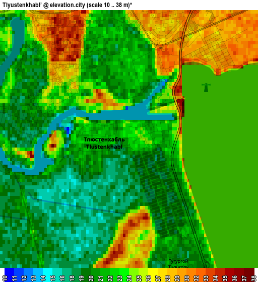
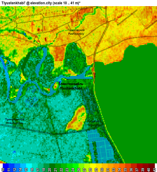
Below is the Elevation map of Tlyustenkhabl’, which displays elevation range with different colors. Scale of the first map is from 10 to 38 m (33 to 125 ft) with average elevation of 22.5 meters (=74 ft) [note 1]
These maps also provides idea of topography and contour of this city, they are displayed at different zoom levels. More info about maps, scale and edge coordinates you can find below images.
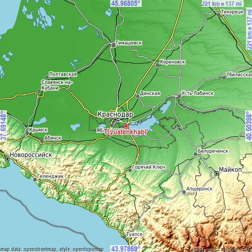
| \ | Map #1 | Map #2 | Topo.Map |
| Scale [m] | 10..38 m | 10..41 m | × |
| Scale [ft] | 33..125 ft | 33..135 ft | × |
| Average | 22.5 m = 74 ft | 23.4 m = 77 ft | × |
| Width | 6.91 km = 4.3 mi | 13.82 km = 8.6 mi | 221.2 km = 137.4 mi |
| Height | 6.91 km = 4.3 mi | 13.82 km = 8.6 mi | 221.2 km = 137.4 mi |
| ↑Max Latitude | 45.013075° | 45.044134° | 45.96805° |
| Latitude at center | 44.982° | 44.982° | 44.982° |
| ↓Min Latitude | 44.950908° | 44.919799° | 43.97869° |
| ← Min Longitude | 39.053785° | 39.009839° | 37.69148° |
| Longitude center | 39.09773° | 39.09773° | 39.09773° |
| →Max Longitude | 39.141675° | 39.185621° | 40.50398° |
Nearby cities:
Cities around Tlyustenkhabl’ sort by population:
• Krasnodar elevation 28 m
11.8 km,  306°
306°
• Pashkovskiy 29 m
4.7 km,  6°
6°
• Yablonovskiy 17 m
12.2 km,  273°
273°
• Yelizavetinskaya 21 m
24.8 km,  286°
286°
• Afipskiy 22 m
22 km,  245°
245°
• Enem 26 m
16.3 km, 247°
• Adygeysk 49 m
13.1 km,  146°
146°
• Starokorsunskaya 38 m
19.1 km,  64°
64°
• Novodmitriyevskaya 37 m
23.9 km,  226°
226°
• Takhtamukay 34 m
10.5 km, 230°
• Agronom 39 m
19.2 km,  23°
23°
• Ponezhukay 39 m
25 km,  114°
114°
Multilingual:
 En español:
Tlyustenkhabl’ elevación 22 m.
 En France:
Tlyustenkhabl’ élévation 22 m.
 Auf Deutsch:
Tlyustenkhabl’ höhe über dem Meeresspiegel ist 22 m.

Sources and notes:
- [note 1] Map square and city borders are not equal. Map elevation data is calculated only from area inside that square.
- [src 1] Elevation data from geonames database provided with same terms of usage.
- [src 2] The elevation map of Tlyustenkhabl’ is generated using elevation data from NASA's 3 arcsec (90m) resolution SRTM data.
- [src 3] Base (background) map © OpenStreetMap contributors tiles are generated by Geofabrik and OpenTopoMap.
Copyright & License:
This Tlyustenkhabl’ Elevation Map is licensed under CC BY-SA. You may reuse any part from this page, if you give a proper credit by linking to this URL:
 More info on terms of use page.