Tsurib elevation
Tsurib (Dagestan), Russia elevation is 1538 meters and Tsurib elevation in feet is 5046 ft above sea level [src 1]. Tsurib is a populated place (feature code) with elevation that is 1339 meters (4393 ft) bigger than average city elevation in Russia.
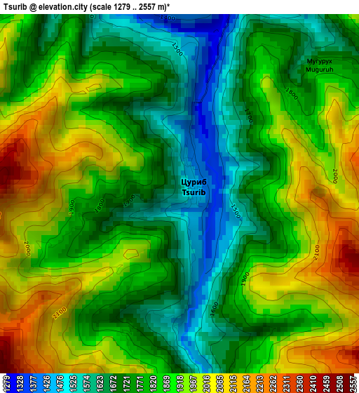
Below is the Elevation map of Tsurib, which displays elevation range with different colors. Scale of the first map is from 1279 to 2557 m (4196 to 8389 ft) with average elevation of 1832.9 meters (=6013 ft) [note 1]
These maps also provides idea of topography and contour of this city, they are displayed at different zoom levels. More info about maps, scale and edge coordinates you can find below images.
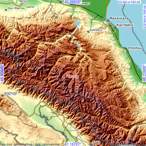
| \ | Map #1 | Topo.Map |
| Scale [m] | 1279..2557 m | × |
| Scale [ft] | 4196..8389 ft | × |
| Average | 1832.9 m = 6013 ft | × |
| Width | 7.24 km = 4.5 mi | 231.5 km = 143.8 mi |
| Height | 7.24 km = 4.5 mi | 231.5 km = 143.8 mi |
| ↑Max Latitude | 42.269328° | 43.26935° |
| Latitude at center | 42.2368° | 42.2368° |
| ↓Min Latitude | 42.204256° | 41.18707° |
| ← Min Longitude | 46.786785° | 45.42448° |
| Longitude center | 46.83073° | 46.83073° |
| →Max Longitude | 46.874675° | 48.23698° |
Nearby cities:
Cities around Tsurib sort by population:
• Levashi elevation 1234 m
45.7 km,  61°
61°
• Khadzhalmakhi 929 m
35.3 km,  54°
54°
• Gergebil’ 729 m
35.5 km,  32°
32°
• Akusha 1394 m
42.2 km,  85°
85°
• Usisha 1479 m
46.3 km, 88°
• Khunzakh 1661 m
35.5 km,  343°
343°
• Kuli 1926 m
41.8 km,  125°
125°
• Khebda 904 m
32.5 km,  315°
315°
• Kumukh 1524 m
24.6 km,  107°
107°
• Gunib 1193 m
20.1 km, 33°
• Irganay 547 m
46 km,  8°
8°
• Tlyarata 1428 m
41.8 km,  249°
249°
Multilingual:
 En español:
Tsurib elevación 1538 m.
 En France:
Tsurib élévation 1538 m.


Sources and notes:
- [note 1] Map square and city borders are not equal. Map elevation data is calculated only from area inside that square.
- [src 1] Elevation data from geonames database provided with same terms of usage.
- [src 2] The elevation map of Tsurib is generated using elevation data from NASA's 3 arcsec (90m) resolution SRTM data.
- [src 3] Base (background) map © OpenStreetMap contributors tiles are generated by Geofabrik and OpenTopoMap.
Copyright & License:
This Tsurib Elevation Map is licensed under CC BY-SA. You may reuse any part from this page, if you give a proper credit by linking to this URL:
 More info on terms of use page.