Tul’skiy elevation
Tul’skiy (Adygeya Republic), Russia elevation is 281 meters and Tul’skiy elevation in feet is 922 ft above sea level [src 1]. Tul’skiy is a seat of a second-order administrative division (feature code) with elevation that is 82 meters (269 ft) bigger than average city elevation in Russia.
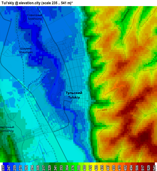
Below is the Elevation map of Tul’skiy, which displays elevation range with different colors. Scale of the first map is from 235 to 541 m (771 to 1775 ft) with average elevation of 344.8 meters (=1131 ft) [note 1]
These maps also provides idea of topography and contour of this city, they are displayed at different zoom levels. More info about maps, scale and edge coordinates you can find below images.

| \ | Map #1 | Topo.Map |
| Scale [m] | 235..541 m | × |
| Scale [ft] | 771..1775 ft | × |
| Average | 344.8 m = 1131 ft | × |
| Width | 6.97 km = 4.3 mi | 223 km = 138.6 mi |
| Height | 6.97 km = 4.3 mi | 223 km = 138.6 mi |
| ↑Max Latitude | 44.544938° | 45.50776° |
| Latitude at center | 44.51361° | 44.51361° |
| ↓Min Latitude | 44.482265° | 43.50221° |
| ← Min Longitude | 40.134945° | 38.77264° |
| Longitude center | 40.17889° | 40.17889° |
| →Max Longitude | 40.222835° | 41.58514° |
Nearby cities:
Cities around Tul’skiy sort by population:
• Maykop elevation 227 m
12 km,  331°
331°
• Belorechensk 118 m
37.2 km,  320°
320°
• Apsheronsk 198 m
35.7 km,  261°
261°
• Giaginskaya 129 m
39.7 km,  347°
347°
• Khanskaya 160 m
25 km, 316°
• Kamennomostskiy 453 m
25 km,  178°
178°
• Yaroslavskaya 264 m
25 km,  64°
64°
• Pshekhskaya 137 m
36.4 km,  303°
303°
• Neftegorsk 333 m
40.9 km,  246°
246°
• Abadzekhskaya 350 m
13.7 km,  165°
165°
• Kuzhorskaya 226 m
20.8 km,  30°
30°
• Yuzhnyy 139 m
33.1 km,  314°
314°
Multilingual:
 En español:
Tul’skiy elevación 281 m.
 En France:
Tul’skiy élévation 281 m.
 Auf Deutsch:
Tul’skiy höhe über dem Meeresspiegel ist 281 m.

Sources and notes:
- [note 1] Map square and city borders are not equal. Map elevation data is calculated only from area inside that square.
- [src 1] Elevation data from geonames database provided with same terms of usage.
- [src 2] The elevation map of Tul’skiy is generated using elevation data from NASA's 3 arcsec (90m) resolution SRTM data.
- [src 3] Base (background) map © OpenStreetMap contributors tiles are generated by Geofabrik and OpenTopoMap.
Copyright & License:
This Tul’skiy Elevation Map is licensed under CC BY-SA. You may reuse any part from this page, if you give a proper credit by linking to this URL:
 More info on terms of use page.