Tuma elevation
Tuma (Ryazan Oblast), Russia elevation is 125 meters and Tuma elevation in feet is 410 ft above sea level [src 1]. Tuma is a populated place (feature code) with elevation that is 74 meters (243 ft) smaller than average city elevation in Russia.
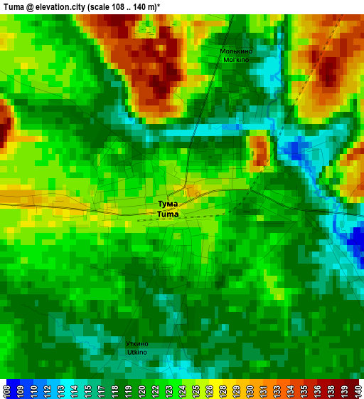
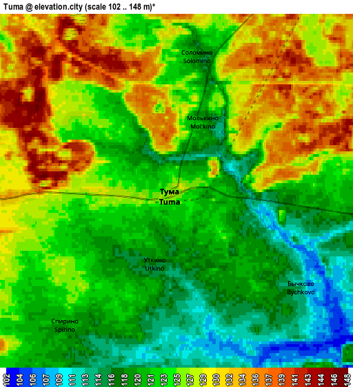
Below is the Elevation map of Tuma, which displays elevation range with different colors. Scale of the first map is from 108 to 140 m (354 to 459 ft) with average elevation of 121.9 meters (=400 ft) [note 1]
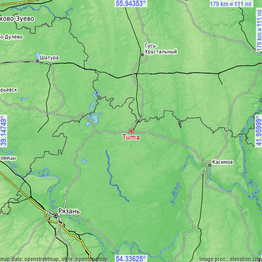
These maps also provides idea of topography and contour of this city, they are displayed at different zoom levels. More info about maps, scale and edge coordinates you can find below images.
| \ | Map #1 | Map #2 | Topo.Map |
| Scale [m] | 108..140 m | 102..148 m | × |
| Scale [ft] | 354..459 ft | 335..486 ft | × |
| Average | 121.9 m = 400 ft | 124.1 m = 407 ft | × |
| Width | 5.58 km = 3.5 mi | 11.17 km = 6.9 mi | 178.7 km = 111 mi |
| Height | 5.58 km = 3.5 mi | 11.17 km = 6.9 mi | 178.7 km = 111 mi |
| ↑Max Latitude | 55.173085° | 55.198174° | 55.94353° |
| Latitude at center | 55.14798° | 55.14798° | 55.14798° |
| ↓Min Latitude | 55.122859° | 55.097723° | 54.33625° |
| ← Min Longitude | 40.509795° | 40.465849° | 39.14749° |
| Longitude center | 40.55374° | 40.55374° | 40.55374° |
| →Max Longitude | 40.597685° | 40.641631° | 41.95999° |
Nearby cities:
Cities around Tuma sort by population:
• Gus’-Khrustal’nyy elevation 133 m
51.9 km,  6°
6°
• Kurlovo 132 m
31.9 km,  352°
352°
• Spas-Klepiki 117 m
24 km,  266°
266°
• Zolotkovo 128 m
54.8 km,  39°
39°
• Gus’-Zheleznyy 114 m
40.2 km,  104°
104°
• Velikodvorskiy 122 m
13.5 km,  32°
32°
• Mezinovskiy 127 m
41.5 km,  342°
342°
• Dmitrovskiy Pogost 128 m
49.2 km,  291°
291°
• Radovitskiy 126 m
48.2 km, 267°
• Syntul 123 m
50 km,  108°
108°
• Lashma 100 m
44.6 km,  122°
122°
• Savinskaya 124 m
43.3 km,  304°
304°
Multilingual:
 En español:
Tuma elevación 125 m.
 En France:
Tuma élévation 125 m.


Sources and notes:
- [note 1] Map square and city borders are not equal. Map elevation data is calculated only from area inside that square.
- [src 1] Elevation data from geonames database provided with same terms of usage.
- [src 2] The elevation map of Tuma is generated using elevation data from NASA's 3 arcsec (90m) resolution SRTM data.
- [src 3] Base (background) map © OpenStreetMap contributors tiles are generated by Geofabrik and OpenTopoMap.
Copyright & License:
This Tuma Elevation Map is licensed under CC BY-SA. You may reuse any part from this page, if you give a proper credit by linking to this URL:
 More info on terms of use page.