Tutayev elevation
Tutayev (Jaroslavl), Russia elevation is 130 meters and Tutayev elevation in feet is 427 ft above sea level [src 1]. Tutayev is a populated place (feature code) with elevation that is 69 meters (226 ft) smaller than average city elevation in Russia.
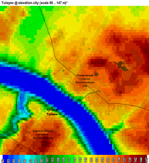
Below is the Elevation map of Tutayev, which displays elevation range with different colors. Scale of the first map is from 80 to 147 m (262 to 482 ft) with average elevation of 118.8 meters (=390 ft) [note 1]
These maps also provides idea of topography and contour of this city, they are displayed at different zoom levels. More info about maps, scale and edge coordinates you can find below images.
| \ | Map #1 | Map #2 | Topo.Map |
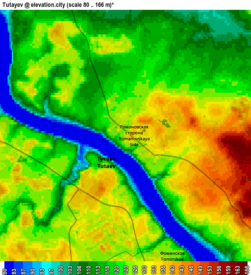
| Scale [m] | 80..147 m | 80..166 m | × |
| Scale [ft] | 262..482 ft | 262..545 ft | × |
| Average | 118.8 m = 390 ft | 120.8 m = 396 ft | × |
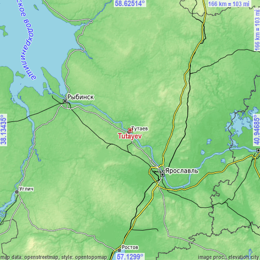
| Width | 5.2 km = 3.2 mi | 10.39 km = 6.5 mi | 166.3 km = 103.3 mi |
| Height | 5.2 km = 3.2 mi | 10.39 km = 6.5 mi | 166.2 km = 103.3 mi |
| ↑Max Latitude | 57.908644° | 57.931984° | 58.62514° |
| Latitude at center | 57.88529° | 57.88529° | 57.88529° |
| ↓Min Latitude | 57.86192° | 57.838536° | 57.1299° |
| ← Min Longitude | 39.496655° | 39.452709° | 38.13435° |
| Longitude center | 39.5406° | 39.5406° | 39.5406° |
| →Max Longitude | 39.584545° | 39.628491° | 40.94685° |
Nearby cities:
Cities around Tutayev sort by population:
• Yaroslavl elevation 103 m
34.6 km,  145°
145°
• Rybinsk 98 m
44.8 km,  293°
293°
• Danilov 175 m
50.3 km,  47°
47°
• Nekrasovskoye 104 m
54.1 km,  115°
115°
• Konstantinovskiy 113 m
6.8 km, 154°
• Krasnyye Tkachi 104 m
45.5 km,  163°
163°
• Bol’shoye Selo 137 m
40.5 km,  242°
242°
• Tunoshna 90 m
51.3 km,  137°
137°
• Pesochnoye 90 m
25.3 km,  302°
302°
• Sudoverf’ 110 m
58.9 km, 295°
• Kurba 145 m
36.1 km,  184°
184°
• Krasnyy Profintern 87 m
55.2 km,  106°
106°
Multilingual:
 En español:
Tutayev elevación 130 m.
 En France:
Tutayev élévation 130 m.


Sources and notes:
- [note 1] Map square and city borders are not equal. Map elevation data is calculated only from area inside that square.
- [src 1] Elevation data from geonames database provided with same terms of usage.
- [src 2] The elevation map of Tutayev is generated using elevation data from NASA's 3 arcsec (90m) resolution SRTM data.
- [src 3] Base (background) map © OpenStreetMap contributors tiles are generated by Geofabrik and OpenTopoMap.
Copyright & License:
This Tutayev Elevation Map is licensed under CC BY-SA. You may reuse any part from this page, if you give a proper credit by linking to this URL:
 More info on terms of use page.