Uchaly elevation
Uchaly (Bashkortostan Republic), Russia elevation is 524 meters and Uchaly elevation in feet is 1719 ft above sea level [src 1]. Uchaly is a populated place (feature code) with elevation that is 325 meters (1066 ft) bigger than average city elevation in Russia.
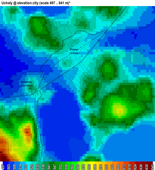
Below is the Elevation map of Uchaly, which displays elevation range with different colors. Scale of the first map is from 497 to 641 m (1631 to 2103 ft) with average elevation of 525.5 meters (=1724 ft) [note 1]
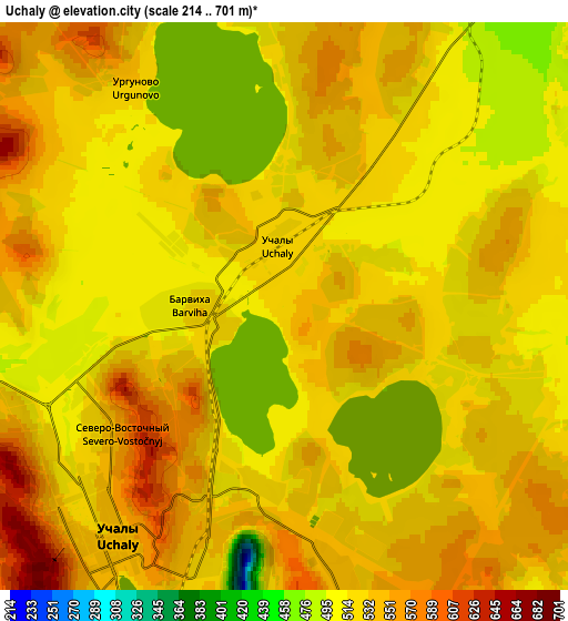
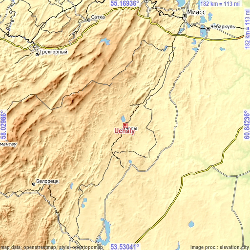
These maps also provides idea of topography and contour of this city, they are displayed at different zoom levels. More info about maps, scale and edge coordinates you can find below images.
| \ | Map #1 | Map #2 | Topo.Map |
| Scale [m] | 497..641 m | 214..701 m | × |
| Scale [ft] | 1631..2103 ft | 702..2300 ft | × |
| Average | 525.5 m = 1724 ft | 531.1 m = 1742 ft | × |
| Width | 5.69 km = 3.5 mi | 11.39 km = 7.1 mi | 182.2 km = 113.2 mi |
| Height | 5.69 km = 3.5 mi | 11.39 km = 7.1 mi | 182.2 km = 113.2 mi |
| ↑Max Latitude | 54.38366° | 54.409244° | 55.16936° |
| Latitude at center | 54.35806° | 54.35806° | 54.35806° |
| ↓Min Latitude | 54.332444° | 54.306813° | 53.53041° |
| ← Min Longitude | 59.392165° | 59.348219° | 58.02986° |
| Longitude center | 59.43611° | 59.43611° | 59.43611° |
| →Max Longitude | 59.480055° | 59.524001° | 60.84236° |
Nearby cities:
Cities around Uchaly sort by population:
• Beloretsk elevation 522 m
80.6 km,  236°
236°
• Satka 413 m
80.2 km,  341°
341°
• Trëkhgornyy 418 m
80.9 km,  308°
308°
• Bakal 597 m
76.4 km,  328°
328°
• Verkhneural’sk 408 m
55.5 km,  195°
195°
• Uyskoye 327 m
36.9 km,  86°
86°
• Mishkino 425 m
45.3 km,  208°
208°
• Tirlyanskiy 536 m
57.9 km,  253°
253°
• Akhunovo 359 m
19.9 km,  147°
147°
• Abzakovo 515 m
80.5 km,  223°
223°
• Mindyak 516 m
56.2 km,  228°
228°
• Leninsk 404 m
66.7 km,  24°
24°
Multilingual:
 En español:
Uchaly elevación 524 m.
 En France:
Uchaly élévation 524 m.


Sources and notes:
- [note 1] Map square and city borders are not equal. Map elevation data is calculated only from area inside that square.
- [src 1] Elevation data from geonames database provided with same terms of usage.
- [src 2] The elevation map of Uchaly is generated using elevation data from NASA's 3 arcsec (90m) resolution SRTM data.
- [src 3] Base (background) map © OpenStreetMap contributors tiles are generated by Geofabrik and OpenTopoMap.
Copyright & License:
This Uchaly Elevation Map is licensed under CC BY-SA. You may reuse any part from this page, if you give a proper credit by linking to this URL:
 More info on terms of use page.