Uglich elevation
Uglich (Jaroslavl), Russia elevation is 120 meters and Uglich elevation in feet is 394 ft above sea level [src 1]. Uglich is a populated place (feature code) with elevation that is 79 meters (259 ft) smaller than average city elevation in Russia.
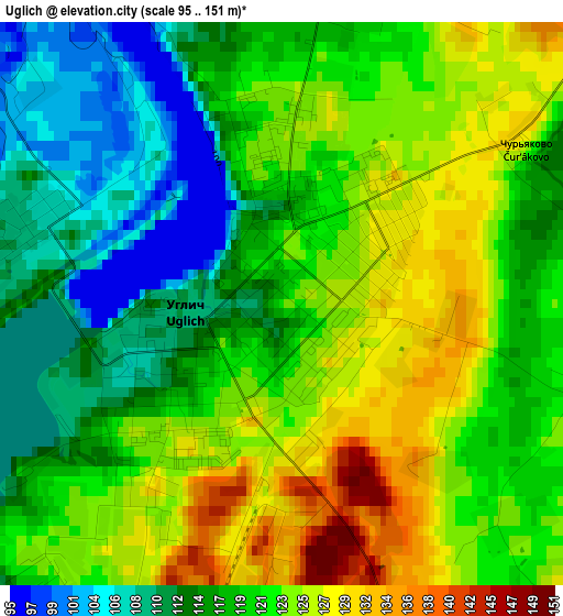
Below is the Elevation map of Uglich, which displays elevation range with different colors. Scale of the first map is from 95 to 151 m (312 to 495 ft) with average elevation of 119.9 meters (=393 ft) [note 1]
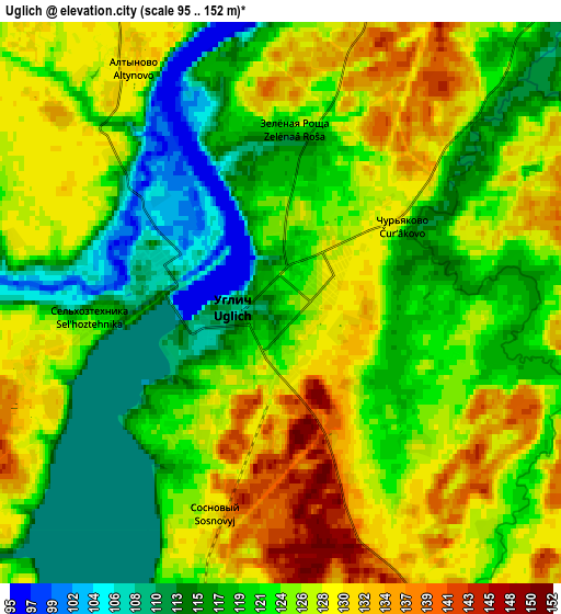
These maps also provides idea of topography and contour of this city, they are displayed at different zoom levels. More info about maps, scale and edge coordinates you can find below images.
| \ | Map #1 | Map #2 | Topo.Map |
| Scale [m] | 95..151 m | 95..152 m | × |
| Scale [ft] | 312..495 ft | 312..499 ft | × |
| Average | 119.9 m = 393 ft | 123.1 m = 404 ft | × |
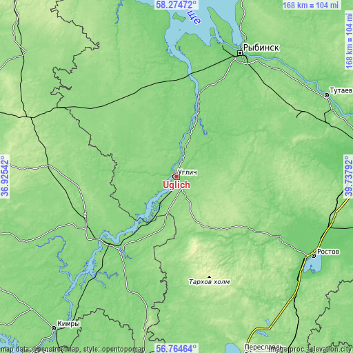
| Width | 5.25 km = 3.3 mi | 10.49 km = 6.5 mi | 167.9 km = 104.3 mi |
| Height | 5.25 km = 3.3 mi | 10.49 km = 6.5 mi | 167.9 km = 104.3 mi |
| ↑Max Latitude | 57.551086° | 57.574657° | 58.27472° |
| Latitude at center | 57.5275° | 57.5275° | 57.5275° |
| ↓Min Latitude | 57.503898° | 57.480281° | 56.76464° |
| ← Min Longitude | 38.287725° | 38.243779° | 36.92542° |
| Longitude center | 38.33167° | 38.33167° | 38.33167° |
| →Max Longitude | 38.375615° | 38.419561° | 39.73792° |
Nearby cities:
Cities around Uglich sort by population:
• Rybinsk elevation 98 m
65 km,  27°
27°
• Kashin 120 m
47.2 km,  246°
246°
• Kalyazin 116 m
43.3 km,  222°
222°
• Myshkin 121 m
30.1 km,  14°
14°
• Borisoglebskiy 120 m
57.5 km,  121°
121°
• Kesova Gora 181 m
62.3 km,  275°
275°
• Bol’shoye Selo 137 m
41.6 km,  59°
59°
• Novyy Nekouz 141 m
44.5 km,  339°
339°
• Volga 123 m
47.3 km,  4°
4°
• Sudoverf’ 110 m
68.1 km,  15°
15°
• Borok 116 m
60.1 km,  354°
354°
• Kurba 145 m
69.7 km,  86°
86°
Multilingual:
 En español:
Uglich elevación 120 m.
 En France:
Ouglitch élévation 120 m.
 Auf Deutsch:
Uglitsch höhe über dem Meeresspiegel ist 120 m.

Sources and notes:
- [note 1] Map square and city borders are not equal. Map elevation data is calculated only from area inside that square.
- [src 1] Elevation data from geonames database provided with same terms of usage.
- [src 2] The elevation map of Uglich is generated using elevation data from NASA's 3 arcsec (90m) resolution SRTM data.
- [src 3] Base (background) map © OpenStreetMap contributors tiles are generated by Geofabrik and OpenTopoMap.
Copyright & License:
This Uglich Elevation Map is licensed under CC BY-SA. You may reuse any part from this page, if you give a proper credit by linking to this URL:
 More info on terms of use page.