Uglyanets elevation
Uglyanets (Voronezj), Russia elevation is 147 meters and Uglyanets elevation in feet is 482 ft above sea level [src 1]. Uglyanets is a populated place (feature code) with elevation that is 52 meters (171 ft) smaller than average city elevation in Russia.
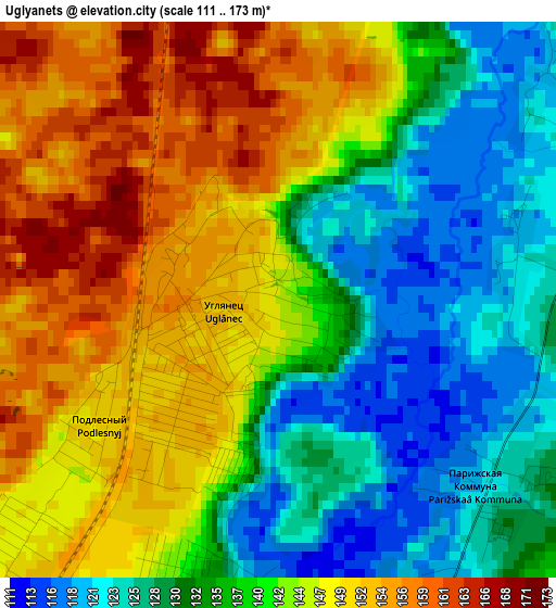
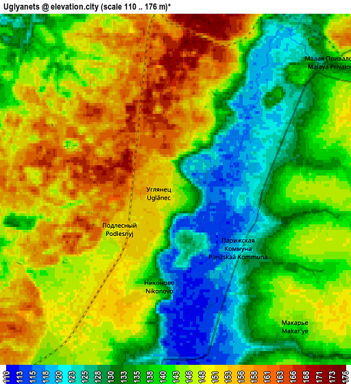
Below is the Elevation map of Uglyanets, which displays elevation range with different colors. Scale of the first map is from 111 to 173 m (364 to 568 ft) with average elevation of 139.6 meters (=458 ft) [note 1]
These maps also provides idea of topography and contour of this city, they are displayed at different zoom levels. More info about maps, scale and edge coordinates you can find below images.
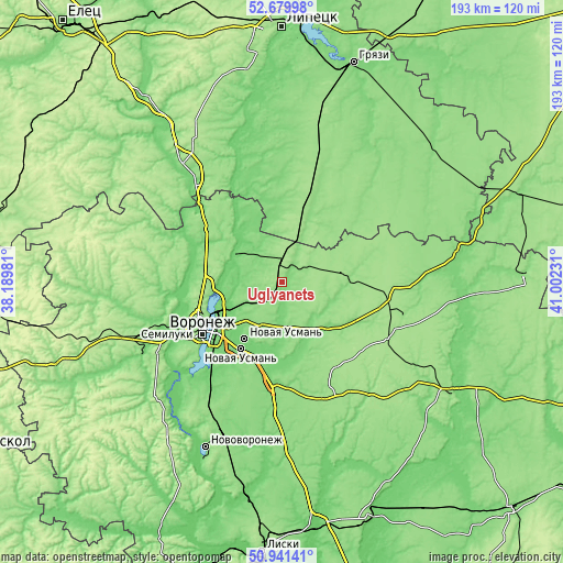
| \ | Map #1 | Map #2 | Topo.Map |
| Scale [m] | 111..173 m | 110..176 m | × |
| Scale [ft] | 364..568 ft | 361..577 ft | × |
| Average | 139.6 m = 458 ft | 142.6 m = 468 ft | × |
| Width | 6.04 km = 3.8 mi | 12.08 km = 7.5 mi | 193.3 km = 120.1 mi |
| Height | 6.04 km = 3.8 mi | 12.08 km = 7.5 mi | 193.3 km = 120.1 mi |
| ↑Max Latitude | 51.846236° | 51.873377° | 52.67998° |
| Latitude at center | 51.81908° | 51.81908° | 51.81908° |
| ↓Min Latitude | 51.791907° | 51.764718° | 50.94141° |
| ← Min Longitude | 39.552115° | 39.508169° | 38.18981° |
| Longitude center | 39.59606° | 39.59606° | 39.59606° |
| →Max Longitude | 39.640005° | 39.683951° | 41.00231° |
Nearby cities:
Cities around Uglyanets sort by population:
• Novaya Usman’ elevation 103 m
23.6 km,  213°
213°
• Usman’ 152 m
26.9 km,  19°
19°
• Somovo 110 m
18 km,  241°
241°
• Ramon’ 150 m
20.8 km,  301°
301°
• Verkhnyaya Khava 148 m
23.8 km,  84°
84°
• Volya 145 m
7.1 km, 212°
• Podgornoye 134 m
32.1 km,  253°
253°
• Krasnolesnyy 154 m
6.9 km,  355°
355°
• Orlovo 130 m
7.3 km,  184°
184°
• Prigorodka 154 m
26.3 km, 17°
• Podkletnoye 109 m
27.1 km,  199°
199°
• Novozhivotinnoye 113 m
30.3 km,  284°
284°
Multilingual:
 En español:
Uglyanets elevación 147 m.
 En France:
Uglyanets élévation 147 m.
 Auf Deutsch:
Uglyanets höhe über dem Meeresspiegel ist 147 m.

Sources and notes:
- [note 1] Map square and city borders are not equal. Map elevation data is calculated only from area inside that square.
- [src 1] Elevation data from geonames database provided with same terms of usage.
- [src 2] The elevation map of Uglyanets is generated using elevation data from NASA's 3 arcsec (90m) resolution SRTM data.
- [src 3] Base (background) map © OpenStreetMap contributors tiles are generated by Geofabrik and OpenTopoMap.
Copyright & License:
This Uglyanets Elevation Map is licensed under CC BY-SA. You may reuse any part from this page, if you give a proper credit by linking to this URL:
 More info on terms of use page.