Ukhta elevation
Ukhta (Komi), Russia elevation is 99 meters and Ukhta elevation in feet is 325 ft above sea level [src 1]. Ukhta is a populated place (feature code) with elevation that is 100 meters (328 ft) smaller than average city elevation in Russia.
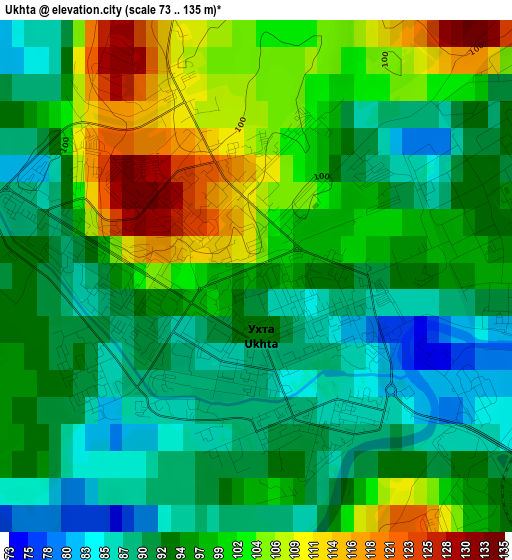
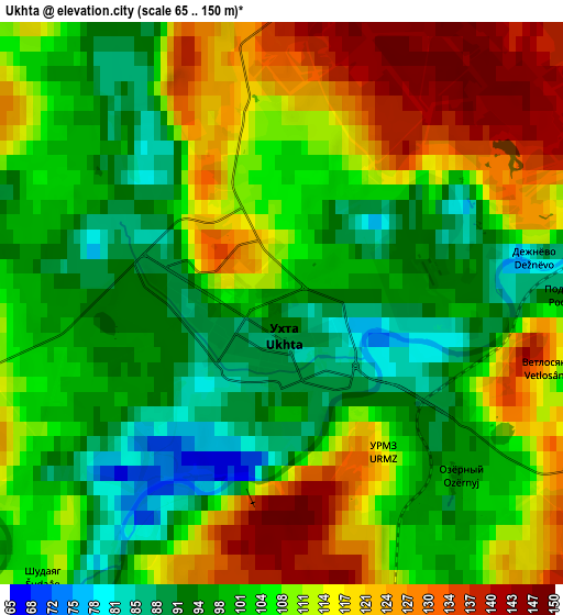
Below is the Elevation map of Ukhta, which displays elevation range with different colors. Scale of the first map is from 73 to 135 m (240 to 443 ft) with average elevation of 96.3 meters (=316 ft) [note 1]
These maps also provides idea of topography and contour of this city, they are displayed at different zoom levels. More info about maps, scale and edge coordinates you can find below images.
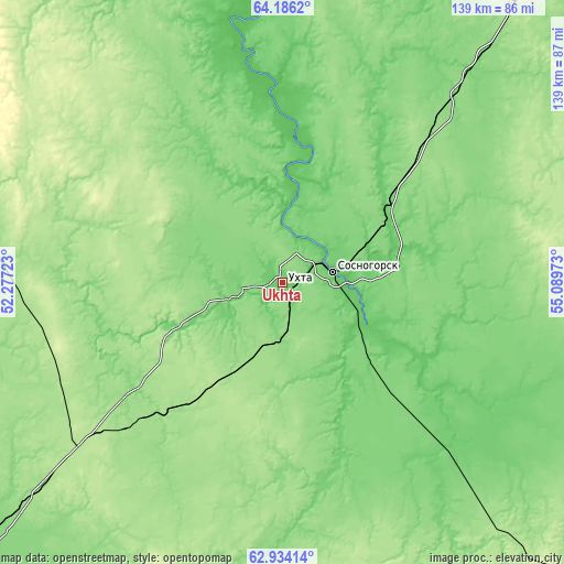
| \ | Map #1 | Map #2 | Topo.Map |
| Scale [m] | 73..135 m | 65..150 m | × |
| Scale [ft] | 240..443 ft | 213..492 ft | × |
| Average | 96.3 m = 316 ft | 106.7 m = 350 ft | × |
| Width | 4.35 km = 2.7 mi | 8.7 km = 5.4 mi | 139.2 km = 86.5 mi |
| Height | 4.35 km = 2.7 mi | 8.7 km = 5.4 mi | 139.2 km = 86.5 mi |
| ↑Max Latitude | 63.586606° | 63.606148° | 64.1862° |
| Latitude at center | 63.56705° | 63.56705° | 63.56705° |
| ↓Min Latitude | 63.547481° | 63.527899° | 62.93414° |
| ← Min Longitude | 53.639535° | 53.595589° | 52.27723° |
| Longitude center | 53.68348° | 53.68348° | 53.68348° |
| →Max Longitude | 53.727425° | 53.771371° | 55.08973° |
Nearby cities:
Cities around Ukhta sort by population:
• Sosnogorsk elevation 82 m
10.6 km,  68°
68°
• Yemva 106 m
178.9 km,  232°
232°
• Vuktyl 107 m
181.4 km,  79°
79°
• Nizhniy Odes 170 m
58.6 km, 81°
• Troitsko-Pechorsk 100 m
158.3 km,  127°
127°
• Yarega 168 m
15.6 km,  199°
199°
• Vodnyy 99 m
15.2 km,  242°
242°
• Voyvozh 217 m
98.7 km,  139°
139°
• Izhma 45 m
160.6 km,  3°
3°
• Shudayag 108 m
5.9 km,  220°
220°
• Sindor 178 m
119.2 km, 228°
• Borovoy 179 m
54.4 km, 226°
Multilingual:
 En español:
Ujtá elevación 99 m.
 En France:
Oukhta élévation 99 m.


Sources and notes:
- [note 1] Map square and city borders are not equal. Map elevation data is calculated only from area inside that square.
- [src 1] Elevation data from geonames database provided with same terms of usage.
- [src 2] The elevation map of Ukhta is generated using GMTED2010 database with 7.5 arcsec (225m) resolution.
- [src 3] Base (background) map © OpenStreetMap contributors tiles are generated by Geofabrik and OpenTopoMap.
Copyright & License:
This Ukhta Elevation Map is licensed under CC BY-SA. You may reuse any part from this page, if you give a proper credit by linking to this URL:
 More info on terms of use page.