Uzlovaya elevation
Uzlovaya (Tula), Russia elevation is 223 meters and Uzlovaya elevation in feet is 732 ft above sea level [src 1]. Uzlovaya is a populated place (feature code) with elevation that is 24 meters (79 ft) bigger than average city elevation in Russia.
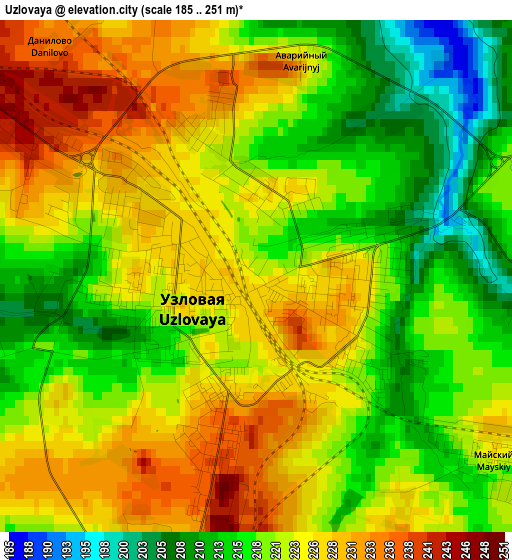
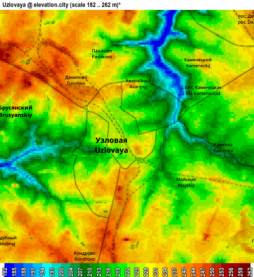
Below is the Elevation map of Uzlovaya, which displays elevation range with different colors. Scale of the first map is from 185 to 251 m (607 to 823 ft) with average elevation of 221.6 meters (=727 ft) [note 1]
These maps also provides idea of topography and contour of this city, they are displayed at different zoom levels. More info about maps, scale and edge coordinates you can find below images.
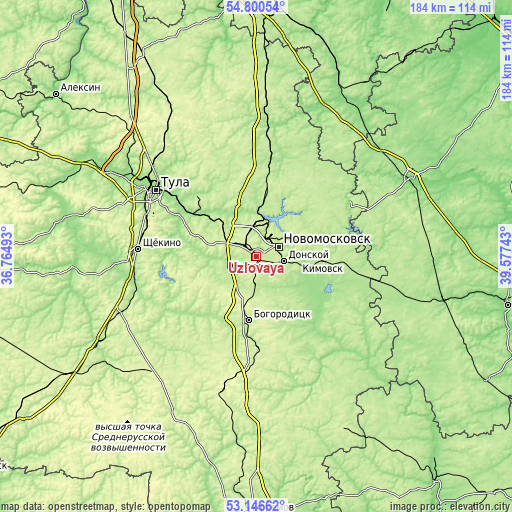
| \ | Map #1 | Map #2 | Topo.Map |
| Scale [m] | 185..251 m | 182..262 m | × |
| Scale [ft] | 607..823 ft | 597..860 ft | × |
| Average | 221.6 m = 727 ft | 225.4 m = 740 ft | × |
| Width | 5.75 km = 3.6 mi | 11.49 km = 7.1 mi | 183.9 km = 114.3 mi |
| Height | 5.75 km = 3.6 mi | 11.49 km = 7.1 mi | 183.9 km = 114.3 mi |
| ↑Max Latitude | 54.007624° | 54.033441° | 54.80054° |
| Latitude at center | 53.98179° | 53.98179° | 53.98179° |
| ↓Min Latitude | 53.95594° | 53.930075° | 53.14662° |
| ← Min Longitude | 38.127235° | 38.083289° | 36.76493° |
| Longitude center | 38.17118° | 38.17118° | 38.17118° |
| →Max Longitude | 38.215125° | 38.259071° | 39.57743° |
Nearby cities:
Cities around Uzlovaya sort by population:
• Novomoskovsk elevation 238 m
8.1 km,  66°
66°
• Donskoy 226 m
10.9 km,  96°
96°
• Kireyevsk 212 m
16.8 km,  251°
251°
• Severo-Zadonsk 232 m
16.2 km, 68°
• Dubovka 212 m
7.8 km, 245°
• Gritsovskiy 215 m
17.3 km,  357°
357°
• Shvartsevskiy 229 m
17 km,  316°
316°
• Brusyanka 195 m
8.8 km,  272°
272°
• Kamenetskiy 233 m
4.8 km,  42°
42°
• Partizan 241 m
5.9 km,  233°
233°
• Mayskiy 224 m
3.4 km,  129°
129°
• Podlesnyy 235 m
7.9 km, 126°
Multilingual:
 En español:
Uzlovaya elevación 223 m.
 En France:
Ouzlovaïa élévation 223 m.
 Auf Deutsch:
Uslowaja höhe über dem Meeresspiegel ist 223 m.

Sources and notes:
- [note 1] Map square and city borders are not equal. Map elevation data is calculated only from area inside that square.
- [src 1] Elevation data from geonames database provided with same terms of usage.
- [src 2] The elevation map of Uzlovaya is generated using elevation data from NASA's 3 arcsec (90m) resolution SRTM data.
- [src 3] Base (background) map © OpenStreetMap contributors tiles are generated by Geofabrik and OpenTopoMap.
Copyright & License:
This Uzlovaya Elevation Map is licensed under CC BY-SA. You may reuse any part from this page, if you give a proper credit by linking to this URL:
 More info on terms of use page.