Vakhrushi elevation
Vakhrushi (Kirov), Russia elevation is 167 meters and Vakhrushi elevation in feet is 548 ft above sea level [src 1]. Vakhrushi is a populated place (feature code) with elevation that is 32 meters (105 ft) smaller than average city elevation in Russia.
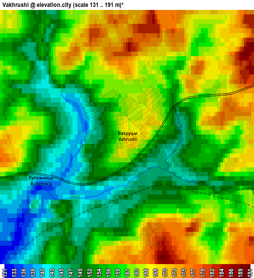
Below is the Elevation map of Vakhrushi, which displays elevation range with different colors. Scale of the first map is from 131 to 191 m (430 to 627 ft) with average elevation of 158.6 meters (=520 ft) [note 1]
These maps also provides idea of topography and contour of this city, they are displayed at different zoom levels. More info about maps, scale and edge coordinates you can find below images.
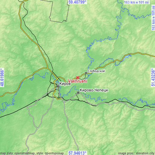
| \ | Map #1 | Map #2 | Topo.Map |
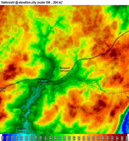
| Scale [m] | 131..191 m | 108..204 m | × |
| Scale [ft] | 430..627 ft | 354..669 ft | × |
| Average | 158.6 m = 520 ft | 166 m = 545 ft | × |
| Width | 5.08 km = 3.2 mi | 10.16 km = 6.3 mi | 162.5 km = 101 mi |
| Height | 5.08 km = 3.2 mi | 10.16 km = 6.3 mi | 162.5 km = 101 mi |
| ↑Max Latitude | 58.707553° | 58.730371° | 59.40799° |
| Latitude at center | 58.68472° | 58.68472° | 58.68472° |
| ↓Min Latitude | 58.661872° | 58.639009° | 57.94613° |
| ← Min Longitude | 49.982165° | 49.938219° | 48.61986° |
| Longitude center | 50.02611° | 50.02611° | 50.02611° |
| →Max Longitude | 50.070055° | 50.114001° | 51.43236° |
Nearby cities:
Cities around Vakhrushi sort by population:
• Kirov elevation 173 m
23.3 km,  245°
245°
• Kirovo-Chepetsk 155 m
14.6 km,  176°
176°
• Slobodskoy 143 m
10.2 km,  58°
58°
• Lyangasovo 142 m
38.3 km,  241°
241°
• Belaya Kholunitsa 144 m
50.7 km,  70°
70°
• Raduzhnyy 157 m
30.3 km,  227°
227°
• Murygino 110 m
33.3 km,  280°
280°
• Strizhi 114 m
49.8 km, 239°
• Stulovo 173 m
8 km, 58°
• Pasegovo 154 m
35.7 km, 236°
• Nizhneivkino 144 m
62 km,  208°
208°
• Torfyanoy 115 m
52.6 km, 245°
Multilingual:
 En español:
Vakhrushi elevación 167 m.
 En France:
Vakhrushi élévation 167 m.
 Auf Deutsch:
Vakhrushi höhe über dem Meeresspiegel ist 167 m.

Sources and notes:
- [note 1] Map square and city borders are not equal. Map elevation data is calculated only from area inside that square.
- [src 1] Elevation data from geonames database provided with same terms of usage.
- [src 2] The elevation map of Vakhrushi is generated using elevation data from NASA's 3 arcsec (90m) resolution SRTM data.
- [src 3] Base (background) map © OpenStreetMap contributors tiles are generated by Geofabrik and OpenTopoMap.
Copyright & License:
This Vakhrushi Elevation Map is licensed under CC BY-SA. You may reuse any part from this page, if you give a proper credit by linking to this URL:
 More info on terms of use page.