Verkhniy Uslon elevation
Verkhniy Uslon (Tatarstan Republic), Russia elevation is 101 meters and Verkhniy Uslon elevation in feet is 331 ft above sea level [src 1]. Verkhniy Uslon is a populated place (feature code) with elevation that is 98 meters (322 ft) smaller than average city elevation in Russia.
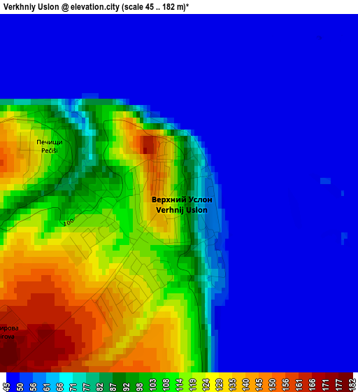
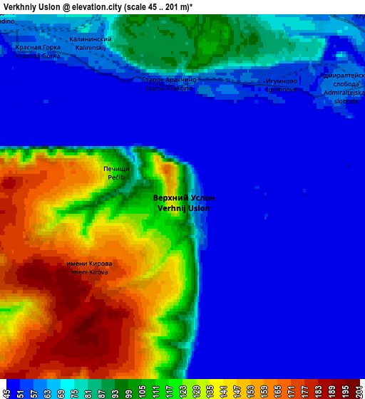
Below is the Elevation map of Verkhniy Uslon, which displays elevation range with different colors. Scale of the first map is from 45 to 182 m (148 to 597 ft) with average elevation of 79.1 meters (=260 ft) [note 1]
These maps also provides idea of topography and contour of this city, they are displayed at different zoom levels. More info about maps, scale and edge coordinates you can find below images.
| \ | Map #1 | Map #2 | Topo.Map |
| Scale [m] | 45..182 m | 45..201 m | × |
| Scale [ft] | 148..597 ft | 148..659 ft | × |
| Average | 79.1 m = 260 ft | 85.3 m = 280 ft | × |
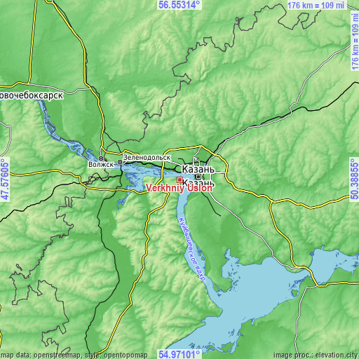
| Width | 5.5 km = 3.4 mi | 10.99 km = 6.8 mi | 175.9 km = 109.3 mi |
| Height | 5.5 km = 3.4 mi | 10.99 km = 6.8 mi | 175.9 km = 109.3 mi |
| ↑Max Latitude | 55.794812° | 55.819508° | 56.55314° |
| Latitude at center | 55.7701° | 55.7701° | 55.7701° |
| ↓Min Latitude | 55.745372° | 55.720629° | 54.97101° |
| ← Min Longitude | 48.938355° | 48.894409° | 47.57605° |
| Longitude center | 48.9823° | 48.9823° | 48.9823° |
| →Max Longitude | 49.026245° | 49.070191° | 50.38855° |
Nearby cities:
Cities around Verkhniy Uslon sort by population:
• Kazan elevation 61 m
9 km,  76°
76°
• Zelenodolsk 104 m
30.2 km,  285°
285°
• Volzhsk 60 m
40.4 km, 285°
• Vasil’yevo 58 m
21.5 km, 289°
• Nizhniye Vyazovyye 61 m
28.8 km,  276°
276°
• Vysokaya Gora 102 m
25.5 km,  51°
51°
• Osinovo 111 m
13.8 km,  332°
332°
• Staroye Arakchino 86 m
3.8 km,  349°
349°
• Privolzhskiy 93 m
41.3 km,  301°
301°
• Stolbishchi 77 m
20.1 km,  133°
133°
• Sviyazhsk 79 m
20.1 km,  271°
271°
• Aysha 78 m
24.6 km, 296°
Multilingual:
 En español:
Verkhniy Uslon elevación 101 m.
 En France:
Verkhniy Uslon élévation 101 m.
 Auf Deutsch:
Verkhniy Uslon höhe über dem Meeresspiegel ist 101 m.
 На русском:
Верхний Услон, Верхний Улсон высота над уровнем моря 101 м
Sources and notes:
- [note 1] Map square and city borders are not equal. Map elevation data is calculated only from area inside that square.
- [src 1] Elevation data from geonames database provided with same terms of usage.
- [src 2] The elevation map of Verkhniy Uslon is generated using elevation data from NASA's 3 arcsec (90m) resolution SRTM data.
- [src 3] Base (background) map © OpenStreetMap contributors tiles are generated by Geofabrik and OpenTopoMap.
Copyright & License:
This Verkhniy Uslon Elevation Map is licensed under CC BY-SA. You may reuse any part from this page, if you give a proper credit by linking to this URL:
 More info on terms of use page.