Vytegra elevation
Vytegra (Vologda), Russia elevation is 46 meters and Vytegra elevation in feet is 151 ft above sea level [src 1]. Vytegra is a populated place (feature code) with elevation that is 153 meters (502 ft) smaller than average city elevation in Russia.
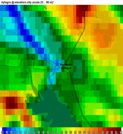
Below is the Elevation map of Vytegra, which displays elevation range with different colors. Scale of the first map is from 23 to 90 m (75 to 295 ft) with average elevation of 52.7 meters (=173 ft) [note 1]
These maps also provides idea of topography and contour of this city, they are displayed at different zoom levels. More info about maps, scale and edge coordinates you can find below images.
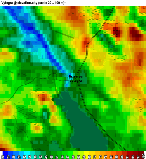
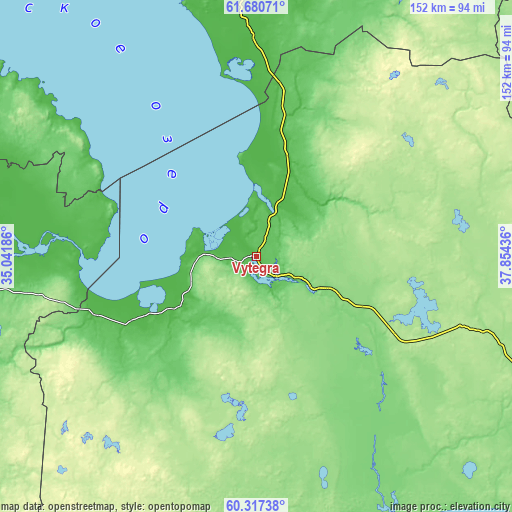
| \ | Map #1 | Map #2 | Topo.Map |
| Scale [m] | 23..90 m | 20..100 m | × |
| Scale [ft] | 75..295 ft | 66..328 ft | × |
| Average | 52.7 m = 173 ft | 56.5 m = 185 ft | × |
| Width | 4.74 km = 2.9 mi | 9.47 km = 5.9 mi | 151.6 km = 94.2 mi |
| Height | 4.74 km = 2.9 mi | 9.47 km = 5.9 mi | 151.6 km = 94.2 mi |
| ↑Max Latitude | 61.027654° | 61.048933° | 61.68071° |
| Latitude at center | 61.00636° | 61.00636° | 61.00636° |
| ↓Min Latitude | 60.985052° | 60.96373° | 60.31738° |
| ← Min Longitude | 36.404165° | 36.360219° | 35.04186° |
| Longitude center | 36.44811° | 36.44811° | 36.44811° |
| →Max Longitude | 36.492055° | 36.536001° | 37.85436° |
Nearby cities:
Cities around Vytegra sort by population:
• Podporozh’ye elevation 56 m
123.4 km,  265°
265°
• Belozërsk 131 m
131.7 km,  145°
145°
• Pudozh 60 m
88.8 km,  2°
2°
• Lipin Bor 133 m
117.4 km,  134°
134°
• Vazhiny 6 m
130.9 km, 267°
• Voznesen’ye 21 m
52.3 km, 270°
• Zubovo 114 m
81.7 km,  159°
159°
• Vinnitsy 72 m
100.1 km,  245°
245°
• Shal’skiy 30 m
90.9 km,  345°
345°
• Kvartsitnyy 54 m
93.2 km,  305°
305°
• Sheltozero 40 m
70.5 km,  304°
304°
• Yaroslavichi 74 m
119.9 km,  241°
241°
Multilingual:
 En español:
Vytegra elevación 46 m.
 En France:
Vytegra élévation 46 m.


Sources and notes:
- [note 1] Map square and city borders are not equal. Map elevation data is calculated only from area inside that square.
- [src 1] Elevation data from geonames database provided with same terms of usage.
- [src 2] The elevation map of Vytegra is generated using GMTED2010 database with 7.5 arcsec (225m) resolution.
- [src 3] Base (background) map © OpenStreetMap contributors tiles are generated by Geofabrik and OpenTopoMap.
Copyright & License:
This Vytegra Elevation Map is licensed under CC BY-SA. You may reuse any part from this page, if you give a proper credit by linking to this URL:
 More info on terms of use page.