Yalkhoy-Mokhk elevation
Yalkhoy-Mokhk (Chechnya), Russia elevation is 387 meters and Yalkhoy-Mokhk elevation in feet is 1270 ft above sea level [src 1]. Yalkhoy-Mokhk is a populated place (feature code) with elevation that is 188 meters (617 ft) bigger than average city elevation in Russia.
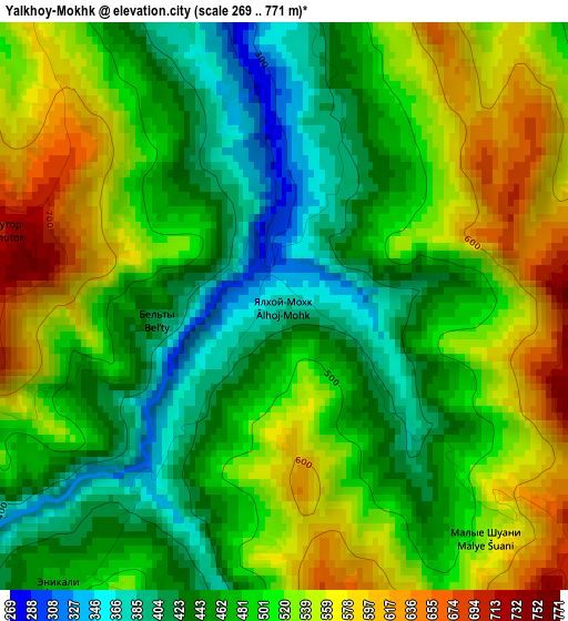
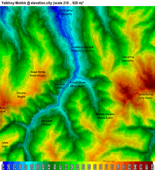
Below is the Elevation map of Yalkhoy-Mokhk, which displays elevation range with different colors. Scale of the first map is from 269 to 771 m (883 to 2530 ft) with average elevation of 495.2 meters (=1625 ft) [note 1]
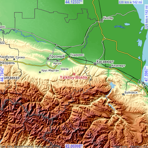
These maps also provides idea of topography and contour of this city, they are displayed at different zoom levels. More info about maps, scale and edge coordinates you can find below images.
| \ | Map #1 | Map #2 | Topo.Map |
| Scale [m] | 269..771 m | 218..928 m | × |
| Scale [ft] | 883..2530 ft | 715..3045 ft | × |
| Average | 495.2 m = 1625 ft | 542.3 m = 1779 ft | × |
| Width | 7.13 km = 4.4 mi | 14.27 km = 8.9 mi | 228.3 km = 141.9 mi |
| Height | 7.13 km = 4.4 mi | 14.27 km = 8.9 mi | 228.3 km = 141.9 mi |
| ↑Max Latitude | 43.137356° | 43.169415° | 44.12337° |
| Latitude at center | 43.10528° | 43.10528° | 43.10528° |
| ↓Min Latitude | 43.073187° | 43.041077° | 42.06998° |
| ← Min Longitude | 46.146505° | 46.102559° | 44.7842° |
| Longitude center | 46.19045° | 46.19045° | 46.19045° |
| →Max Longitude | 46.234395° | 46.278341° | 47.5967° |
Nearby cities:
Cities around Yalkhoy-Mokhk sort by population:
• Kurchaloy elevation 169 m
13.6 km,  322°
322°
• Avtury 248 m
16.6 km,  292°
292°
• Bachi-Yurt 193 m
13.2 km,  1°
1°
• Oyskhara 123 m
18.3 km,  14°
14°
• Mayrtup 189 m
11.9 km,  336°
336°
• Alleroy 270 m
14.5 km,  30°
30°
• Tsentoroy 854 m
11.3 km,  166°
166°
• Nozhay-Yurt 510 m
15.3 km,  95°
95°
• Serzhen’-Yurt 324 m
16.7 km,  276°
276°
• Dyshne-Vedeno 767 m
16.8 km,  201°
201°
• Ishkhoy-Yurt 243 m
20.1 km,  53°
53°
• Vedeno 722 m
17 km,  206°
206°
Multilingual:
 En español:
Yalkhoy-Mokhk elevación 387 m.
 En France:
Yalkhoy-Mokhk élévation 387 m.
 Auf Deutsch:
Yalkhoy-Mokhk höhe über dem Meeresspiegel ist 387 m.

Sources and notes:
- [note 1] Map square and city borders are not equal. Map elevation data is calculated only from area inside that square.
- [src 1] Elevation data from geonames database provided with same terms of usage.
- [src 2] The elevation map of Yalkhoy-Mokhk is generated using elevation data from NASA's 3 arcsec (90m) resolution SRTM data.
- [src 3] Base (background) map © OpenStreetMap contributors tiles are generated by Geofabrik and OpenTopoMap.
Copyright & License:
This Yalkhoy-Mokhk Elevation Map is licensed under CC BY-SA. You may reuse any part from this page, if you give a proper credit by linking to this URL:
 More info on terms of use page.