Zhigulevsk elevation
Zhigulevsk (Samara Oblast), Russia elevation is 75 meters and Zhigulevsk elevation in feet is 246 ft above sea level [src 1]. Zhigulevsk is a populated place (feature code) with elevation that is 124 meters (407 ft) smaller than average city elevation in Russia.
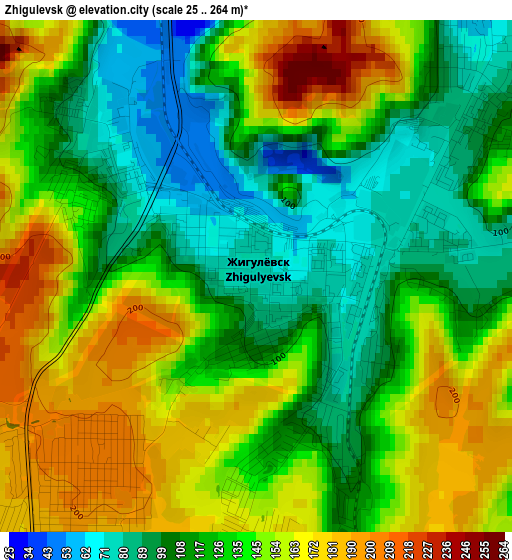
Below is the Elevation map of Zhigulevsk, which displays elevation range with different colors. Scale of the first map is from 25 to 264 m (82 to 866 ft) with average elevation of 133.2 meters (=437 ft) [note 1]
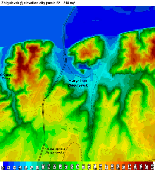
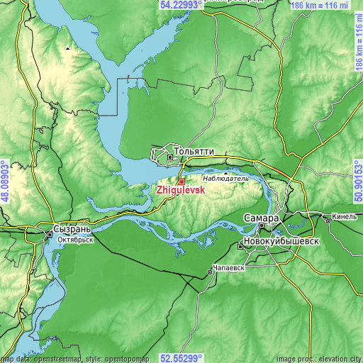
These maps also provides idea of topography and contour of this city, they are displayed at different zoom levels. More info about maps, scale and edge coordinates you can find below images.
| \ | Map #1 | Map #2 | Topo.Map |
| Scale [m] | 25..264 m | 22..318 m | × |
| Scale [ft] | 82..866 ft | 72..1043 ft | × |
| Average | 133.2 m = 437 ft | 138 m = 453 ft | × |
| Width | 5.83 km = 3.6 mi | 11.65 km = 7.2 mi | 186.5 km = 115.9 mi |
| Height | 5.83 km = 3.6 mi | 11.65 km = 7.2 mi | 186.4 km = 115.8 mi |
| ↑Max Latitude | 53.425913° | 53.452091° | 54.22993° |
| Latitude at center | 53.39972° | 53.39972° | 53.39972° |
| ↓Min Latitude | 53.37351° | 53.347285° | 52.55299° |
| ← Min Longitude | 49.451335° | 49.407389° | 48.08903° |
| Longitude center | 49.49528° | 49.49528° | 49.49528° |
| →Max Longitude | 49.539225° | 49.583171° | 50.90153° |
Nearby cities:
Cities around Zhigulevsk sort by population:
• Tol’yatti elevation 92 m
17.6 km,  325°
325°
• Pribrezhnyy 175 m
25.9 km,  68°
68°
• Povolzhskiy 153 m
27.2 km,  40°
40°
• Volzhskiy 47 m
41.5 km,  85°
85°
• Kurumoch 61 m
37.3 km, 74°
• Mezhdurechensk 79 m
29.5 km,  239°
239°
• Podstepki 66 m
27.1 km,  298°
298°
• Zol’noye 97 m
20.6 km,  76°
76°
• Zhiguli 140 m
13.7 km,  250°
250°
• Bakhilovo 262 m
9.3 km, 89°
• Perevoloki 62 m
27.1 km,  230°
230°
• Bogatyr’ 53 m
30 km, 83°
Multilingual:
 En español:
Zhigulevsk elevación 75 m.
 En France:
Zhigulevsk élévation 75 m.
 Auf Deutsch:
Zhigulevsk höhe über dem Meeresspiegel ist 75 m.

Sources and notes:
- [note 1] Map square and city borders are not equal. Map elevation data is calculated only from area inside that square.
- [src 1] Elevation data from geonames database provided with same terms of usage.
- [src 2] The elevation map of Zhigulevsk is generated using elevation data from NASA's 3 arcsec (90m) resolution SRTM data.
- [src 3] Base (background) map © OpenStreetMap contributors tiles are generated by Geofabrik and OpenTopoMap.
Copyright & License:
This Zhigulevsk Elevation Map is licensed under CC BY-SA. You may reuse any part from this page, if you give a proper credit by linking to this URL:
 More info on terms of use page.