Zhizdra elevation
Zhizdra (Kaluga), Russia elevation is 185 meters and Zhizdra elevation in feet is 607 ft above sea level [src 1]. Zhizdra is a populated place (feature code) with elevation that is 14 meters (46 ft) smaller than average city elevation in Russia.
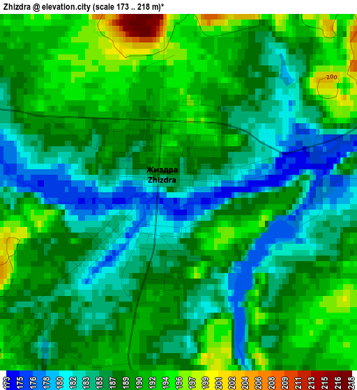
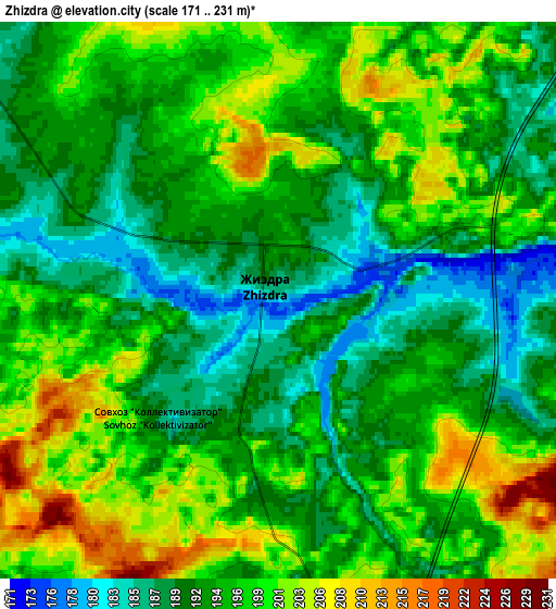
Below is the Elevation map of Zhizdra, which displays elevation range with different colors. Scale of the first map is from 173 to 218 m (568 to 715 ft) with average elevation of 188.1 meters (=617 ft) [note 1]
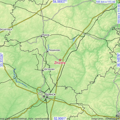
These maps also provides idea of topography and contour of this city, they are displayed at different zoom levels. More info about maps, scale and edge coordinates you can find below images.
| \ | Map #1 | Map #2 | Topo.Map |
| Scale [m] | 173..218 m | 171..231 m | × |
| Scale [ft] | 568..715 ft | 561..758 ft | × |
| Average | 188.1 m = 617 ft | 195 m = 640 ft | × |
| Width | 5.78 km = 3.6 mi | 11.56 km = 7.2 mi | 184.9 km = 114.9 mi |
| Height | 5.78 km = 3.6 mi | 11.56 km = 7.2 mi | 184.9 km = 114.9 mi |
| ↑Max Latitude | 53.77194° | 53.797903° | 54.56937° |
| Latitude at center | 53.74596° | 53.74596° | 53.74596° |
| ↓Min Latitude | 53.719964° | 53.693952° | 52.9061° |
| ← Min Longitude | 34.695565° | 34.651619° | 33.33326° |
| Longitude center | 34.73951° | 34.73951° | 34.73951° |
| →Max Longitude | 34.783455° | 34.827401° | 36.14576° |
Nearby cities:
Cities around Zhizdra sort by population:
• Lyudinovo elevation 182 m
23.4 km,  304°
304°
• Kirov 200 m
45.9 km,  321°
321°
• Dyat’kovo 206 m
31.1 km,  238°
238°
• Sukhinichi 212 m
55.7 km,  45°
45°
• Duminichi 189 m
32.1 km, 49°
• Ivot 180 m
37.2 km,  257°
257°
• Lyubokhna 164 m
35.5 km,  220°
220°
• Star’ 183 m
41 km,  250°
250°
• Khvastovichi 179 m
38.6 km,  142°
142°
• Bytosh’ 184 m
43.4 km,  280°
280°
• Raditsa-Krylovka 148 m
54 km,  207°
207°
• Seredeyskiy 215 m
46.8 km,  43°
43°
Multilingual:
 En español:
Zhizdra elevación 185 m.
 En France:
Zhizdra élévation 185 m.


Sources and notes:
- [note 1] Map square and city borders are not equal. Map elevation data is calculated only from area inside that square.
- [src 1] Elevation data from geonames database provided with same terms of usage.
- [src 2] The elevation map of Zhizdra is generated using elevation data from NASA's 3 arcsec (90m) resolution SRTM data.
- [src 3] Base (background) map © OpenStreetMap contributors tiles are generated by Geofabrik and OpenTopoMap.
Copyright & License:
This Zhizdra Elevation Map is licensed under CC BY-SA. You may reuse any part from this page, if you give a proper credit by linking to this URL:
 More info on terms of use page.