Mezgor'e elevation
Mezgor'e (Bashkortostan Republic), Russia elevation is 627 meters and Mezgor'e elevation in feet is 2057 ft above sea level [src 1]. Mezgor'e is a populated place (feature code) with elevation that is 428 meters (1404 ft) bigger than average city elevation in Russia.
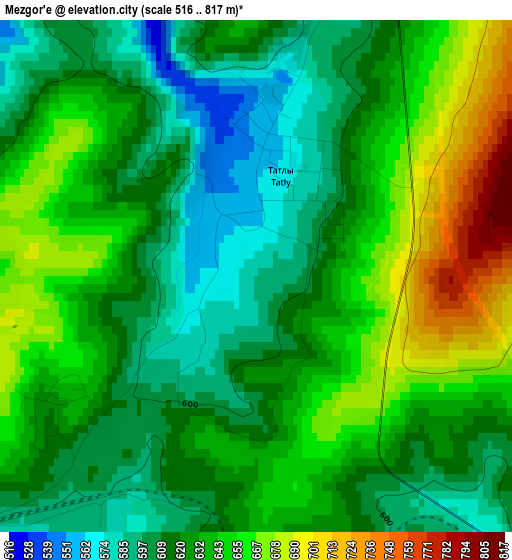
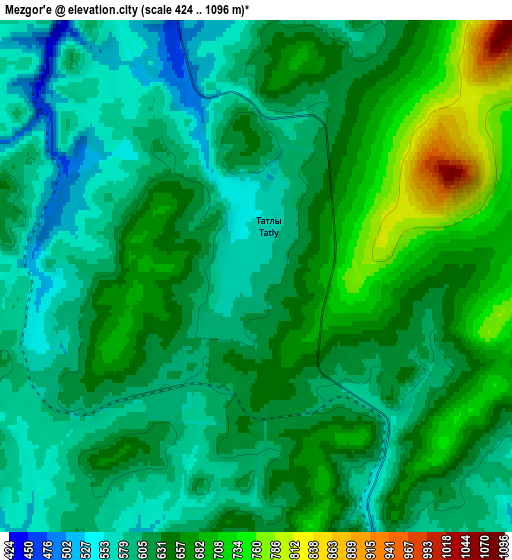
Below is the Elevation map of Mezgor'e, which displays elevation range with different colors. Scale of the first map is from 516 to 817 m (1693 to 2680 ft) with average elevation of 630.6 meters (=2069 ft) [note 1]
These maps also provides idea of topography and contour of this city, they are displayed at different zoom levels. More info about maps, scale and edge coordinates you can find below images.
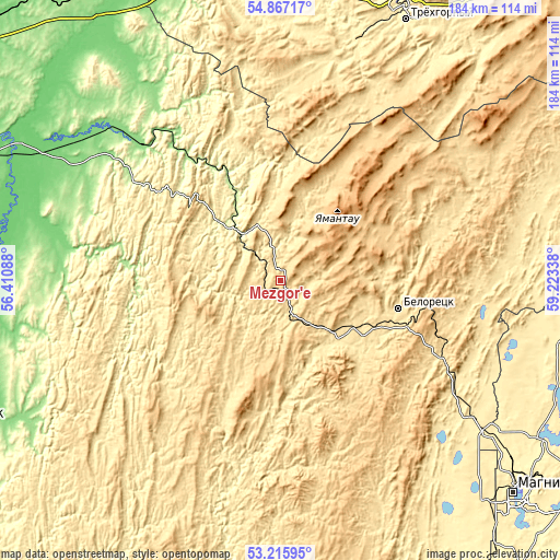
| \ | Map #1 | Map #2 | Topo.Map |
| Scale [m] | 516..817 m | 424..1096 m | × |
| Scale [ft] | 1693..2680 ft | 1391..3596 ft | × |
| Average | 630.6 m = 2069 ft | 626.4 m = 2055 ft | × |
| Width | 5.74 km = 3.6 mi | 11.47 km = 7.1 mi | 183.6 km = 114.1 mi |
| Height | 5.74 km = 3.6 mi | 11.47 km = 7.1 mi | 183.6 km = 114.1 mi |
| ↑Max Latitude | 54.075552° | 54.101327° | 54.86717° |
| Latitude at center | 54.04976° | 54.04976° | 54.04976° |
| ↓Min Latitude | 54.023952° | 53.998129° | 53.21595° |
| ← Min Longitude | 57.773185° | 57.729239° | 56.41088° |
| Longitude center | 57.81713° | 57.81713° | 57.81713° |
| →Max Longitude | 57.861075° | 57.905021° | 59.22338° |
Nearby cities:
Cities around Mezgor'e sort by population:
• Beloretsk elevation 522 m
39.2 km,  104°
104°
• Trëkhgornyy 418 m
94.7 km,  26°
26°
• Katav-Ivanovsk 397 m
81.9 km,  17°
17°
• Verkhneural’sk 408 m
93.2 km, 101°
• Mishkino 425 m
84.4 km,  93°
93°
• Tirlyanskiy 536 m
52.9 km,  70°
70°
• Inzer 282 m
25.2 km,  317°
317°
• Abzakovo 515 m
56.4 km,  115°
115°
• Lomovka 506 m
38.8 km,  111°
111°
• Mindyak 516 m
63.5 km, 92°
• Verkhniy Avzyan 448 m
60.8 km,  197°
197°
• Tukan 548 m
33.2 km,  225°
225°
Multilingual:
 En español:
Mezgor'e elevación 627 m.
 En France:
Mezgor'e élévation 627 m.
 Auf Deutsch:
Mezgor'e höhe über dem Meeresspiegel ist 627 m.

Sources and notes:
- [note 1] Map square and city borders are not equal. Map elevation data is calculated only from area inside that square.
- [src 1] Elevation data from geonames database provided with same terms of usage.
- [src 2] The elevation map of Mezgor'e is generated using elevation data from NASA's 3 arcsec (90m) resolution SRTM data.
- [src 3] Base (background) map © OpenStreetMap contributors tiles are generated by Geofabrik and OpenTopoMap.
Copyright & License:
This Mezgor'e Elevation Map is licensed under CC BY-SA. You may reuse any part from this page, if you give a proper credit by linking to this URL:
 More info on terms of use page.