Raduzhnyy elevation
Raduzhnyy (Vladimir), Russia elevation is 160 meters and Raduzhnyy elevation in feet is 525 ft above sea level [src 1]. Raduzhnyy is a populated place (feature code) with elevation that is 39 meters (128 ft) smaller than average city elevation in Russia.
Below is the Elevation map of Raduzhnyy, which displays elevation range with different colors. Scale of the first map is from 93 to 176 m (305 to 577 ft) with average elevation of 141 meters (=463 ft) [note 1]
These maps also provides idea of topography and contour of this city, they are displayed at different zoom levels. More info about maps, scale and edge coordinates you can find below images.
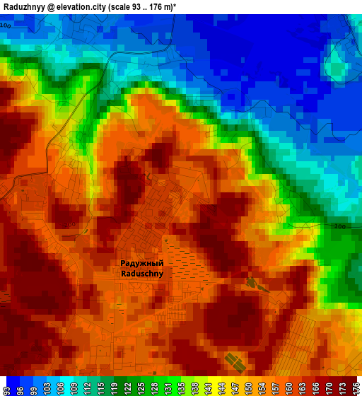
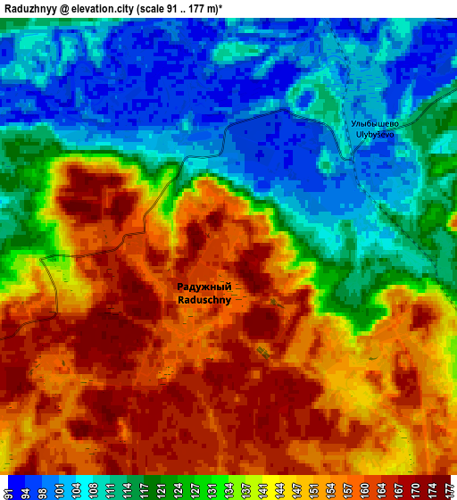
| \ | Map #1 | Map #2 | Topo.Map |
| Scale [m] | 93..176 m | 91..177 m | × |
| Scale [ft] | 305..577 ft | 299..581 ft | × |
| Average | 141 m = 463 ft | 134.2 m = 440 ft | × |
| Width | 5.46 km = 3.4 mi | 10.93 km = 6.8 mi | 174.9 km = 108.7 mi |
| Height | 5.46 km = 3.4 mi | 10.93 km = 6.8 mi | 174.8 km = 108.6 mi |
| ↑Max Latitude | 56.028364° | 56.052912° | 56.78212° |
| Latitude at center | 56.0038° | 56.0038° | 56.0038° |
| ↓Min Latitude | 55.979221° | 55.954626° | 55.20948° |
| ← Min Longitude | 40.295105° | 40.251159° | 38.9328° |
| Longitude center | 40.33905° | 40.33905° | 40.33905° |
| →Max Longitude | 40.382995° | 40.426941° | 41.7453° |
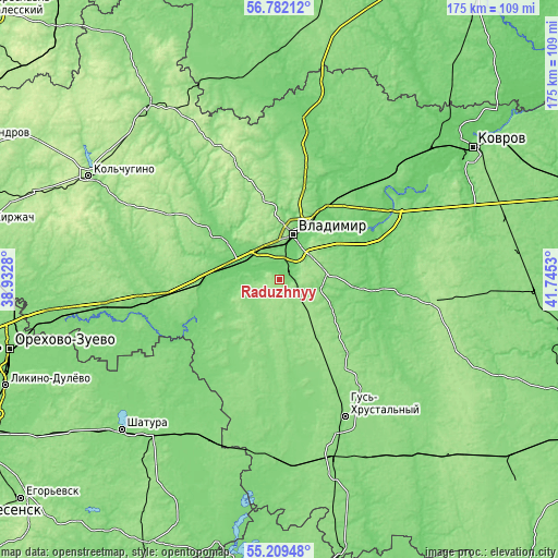
Nearby cities:
Cities around Raduzhnyy sort by population:
• Vladimir elevation 140 m
15.2 km,  13°
13°
• Sobinka 105 m
20.5 km,  264°
264°
• Lakinsk 129 m
24.3 km,  274°
274°
• Sudogda 98 m
33.1 km,  99°
99°
• Stavrovo 116 m
24.8 km,  305°
305°
• Orgtrud 114 m
26.3 km,  40°
40°
• Bogolyubovo 131 m
23.7 km,  28°
28°
• Kommunar 101 m
13.8 km, 28°
• Muromtsevo 117 m
36.3 km, 102°
• Golovino 154 m
7.1 km,  131°
131°
• Ivanishchi 130 m
26.1 km,  167°
167°
• Vorsha 107 m
16.9 km,  287°
287°
Multilingual:
 En español:
Raduzhnyy elevación 160 m.
 En France:
Raduzhnyy élévation 160 m.
 Auf Deutsch:
Raduzhnyy höhe über dem Meeresspiegel ist 160 m.

Sources and notes:
- [note 1] Map square and city borders are not equal. Map elevation data is calculated only from area inside that square.
- [src 1] Elevation data from geonames database provided with same terms of usage.
- [src 2] The elevation map of Raduzhnyy is generated using elevation data from NASA's 3 arcsec (90m) resolution SRTM data.
- [src 3] Base (background) map © OpenStreetMap contributors tiles are generated by Geofabrik and OpenTopoMap.
Copyright & License:
This Raduzhnyy Elevation Map is licensed under CC BY-SA. You may reuse any part from this page, if you give a proper credit by linking to this URL:
 More info on terms of use page.