Langepas elevation
Langepas (Khanty-Mansia), Russia elevation is 50 meters and Langepas elevation in feet is 164 ft above sea level [src 1]. Langepas is a populated place (feature code) with elevation that is 149 meters (489 ft) smaller than average city elevation in Russia.
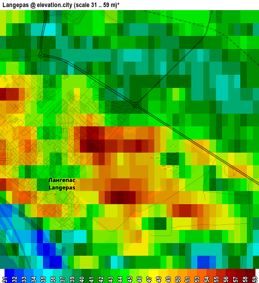
Below is the Elevation map of Langepas, which displays elevation range with different colors. Scale of the first map is from 31 to 59 m (102 to 194 ft) with average elevation of 43.9 meters (=144 ft) [note 1]
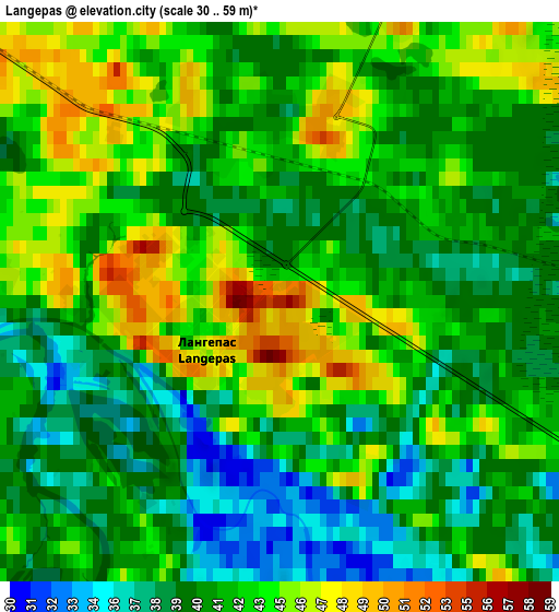
These maps also provides idea of topography and contour of this city, they are displayed at different zoom levels. More info about maps, scale and edge coordinates you can find below images.
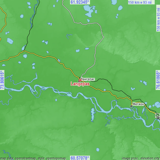
| \ | Map #1 | Map #2 | Topo.Map |
| Scale [m] | 31..59 m | 30..59 m | × |
| Scale [ft] | 102..194 ft | 98..194 ft | × |
| Average | 43.9 m = 144 ft | 41.7 m = 137 ft | × |
| Width | 4.7 km = 2.9 mi | 9.4 km = 5.8 mi | 150.4 km = 93.5 mi |
| Height | 4.7 km = 2.9 mi | 9.4 km = 5.8 mi | 150.4 km = 93.5 mi |
| ↑Max Latitude | 61.275517° | 61.29663° | 61.92345° |
| Latitude at center | 61.25439° | 61.25439° | 61.25439° |
| ↓Min Latitude | 61.233249° | 61.212093° | 60.57078° |
| ← Min Longitude | 75.168455° | 75.124509° | 73.80615° |
| Longitude center | 75.2124° | 75.2124° | 75.2124° |
| →Max Longitude | 75.256345° | 75.300291° | 76.61865° |
Nearby cities:
Cities around Langepas sort by population:
• Surgut elevation 37 m
96 km,  269°
269°
• Nizhnevartovsk 50 m
80.4 km,  116°
116°
• Kogalym 93 m
118.8 km,  341°
341°
• Megion 47 m
54.4 km, 117°
• Poykovskiy 23 m
100.5 km, 268°
• Fedorovskiy 71 m
88.8 km,  296°
296°
• Izluchinsk 52 m
96.9 km,  108°
108°
• Pokachi 54 m
52.4 km,  9°
9°
• Solnechniy 49 m
108.6 km, 271°
• Novoagansk 74 m
108.5 km,  44°
44°
• Barsovo 42 m
110 km,  264°
264°
• Lokosovo 44 m
25.1 km,  237°
237°
Multilingual:
 En español:
Langepas elevación 50 m.
 En France:
Langepas élévation 50 m.


Sources and notes:
- [note 1] Map square and city borders are not equal. Map elevation data is calculated only from area inside that square.
- [src 1] Elevation data from geonames database provided with same terms of usage.
- [src 2] The elevation map of Langepas is generated using GMTED2010 database with 7.5 arcsec (225m) resolution.
- [src 3] Base (background) map © OpenStreetMap contributors tiles are generated by Geofabrik and OpenTopoMap.
Copyright & License:
This Langepas Elevation Map is licensed under CC BY-SA. You may reuse any part from this page, if you give a proper credit by linking to this URL:
 More info on terms of use page.