De-Kastri elevation
De-Kastri (Khabarovsk), Russia elevation is 47 meters and De-Kastri elevation in feet is 154 ft above sea level [src 1]. De-Kastri is a populated place (feature code) with elevation that is 152 meters (499 ft) smaller than average city elevation in Russia.
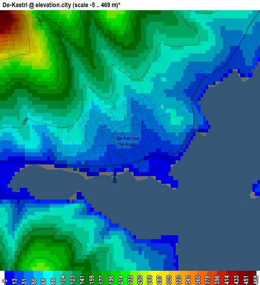
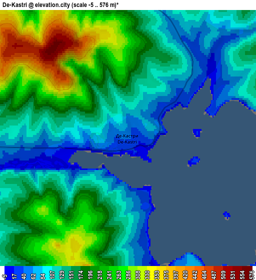
Below is the Elevation map of De-Kastri, which displays elevation range with different colors. Scale of the first map is from -5 to 469 m (-16 to 1539 ft) with average elevation of 98.5 meters (=323 ft) [note 1]
These maps also provides idea of topography and contour of this city, they are displayed at different zoom levels. More info about maps, scale and edge coordinates you can find below images.
| \ | Map #1 | Map #2 | Topo.Map |
| Scale [m] | -5..469 m | -5..576 m | × |
| Scale [ft] | -16..1539 ft | -16..1890 ft | × |
| Average | 98.5 m = 323 ft | 169.8 m = 557 ft | × |
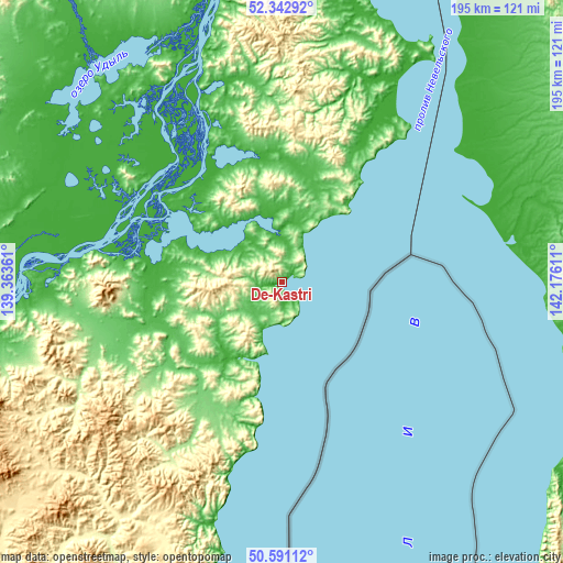
| Width | 6.09 km = 3.8 mi | 12.17 km = 7.6 mi | 194.8 km = 121 mi |
| Height | 6.09 km = 3.8 mi | 12.17 km = 7.6 mi | 194.8 km = 121 mi |
| ↑Max Latitude | 51.502793° | 51.53014° | 52.34292° |
| Latitude at center | 51.47543° | 51.47543° | 51.47543° |
| ↓Min Latitude | 51.44805° | 51.420654° | 50.59112° |
| ← Min Longitude | 140.725915° | 140.681969° | 139.36361° |
| Longitude center | 140.76986° | 140.76986° | 140.76986° |
| →Max Longitude | 140.813805° | 140.857751° | 142.17611° |
Nearby cities:
Cities around De-Kastri sort by population:
• Nikolayevsk-on-Amure elevation 40 m
185.8 km,  359°
359°
• Aleksandrovsk-Sakhalinskiy 36 m
116.3 km,  123°
123°
• Nogliki 9 m
167.4 km,  77°
77°
• Tymovskoye 117 m
149.4 km, 117°
• Smirnykh 81 m
241.3 km,  142°
142°
• Bogorodskoye 36 m
102.5 km,  347°
347°
• Vysokogornyy 451 m
191.9 km,  217°
217°
• Mago 3 m
202.2 km, 348°
• Lazarev 14 m
97.5 km,  31°
31°
• Mgachi 43 m
114.6 km,  114°
114°
• Boshnyakovo 11 m
226.2 km,  154°
154°
• Tungor 41 m
259.5 km, 34°
Multilingual:
 En español:
De-Kastri elevación 47 m.
 En France:
De-Kastri élévation 47 m.
 Auf Deutsch:
De-Kastri höhe über dem Meeresspiegel ist 47 m.

Sources and notes:
- [note 1] Map square and city borders are not equal. Map elevation data is calculated only from area inside that square.
- [src 1] Elevation data from geonames database provided with same terms of usage.
- [src 2] The elevation map of De-Kastri is generated using elevation data from NASA's 3 arcsec (90m) resolution SRTM data.
- [src 3] Base (background) map © OpenStreetMap contributors tiles are generated by Geofabrik and OpenTopoMap.
Copyright & License:
This De-Kastri Elevation Map is licensed under CC BY-SA. You may reuse any part from this page, if you give a proper credit by linking to this URL:
 More info on terms of use page.