Balyaga elevation
Balyaga (Transbaikal Territory), Russia elevation is 738 meters and Balyaga elevation in feet is 2421 ft above sea level [src 1]. Balyaga is a populated place (feature code) with elevation that is 539 meters (1768 ft) bigger than average city elevation in Russia.
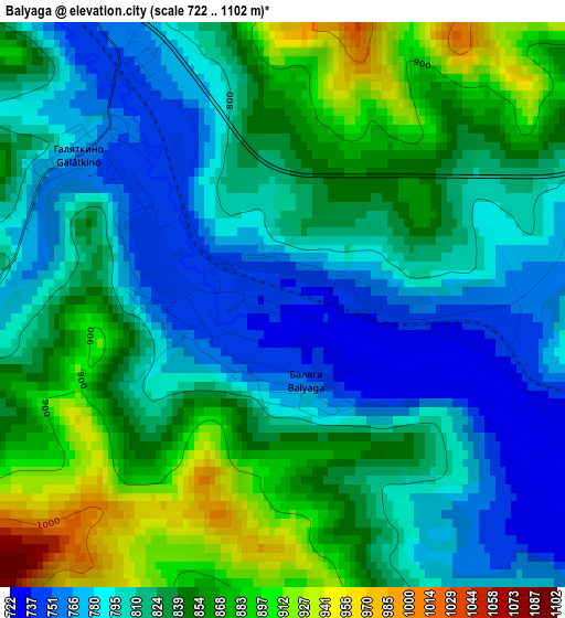
Below is the Elevation map of Balyaga, which displays elevation range with different colors. Scale of the first map is from 722 to 1102 m (2369 to 3615 ft) with average elevation of 825.2 meters (=2707 ft) [note 1]
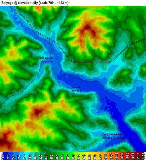
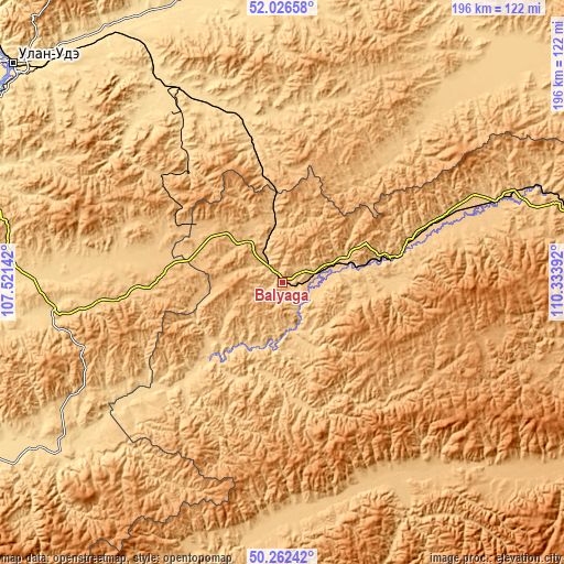
These maps also provides idea of topography and contour of this city, they are displayed at different zoom levels. More info about maps, scale and edge coordinates you can find below images.
| \ | Map #1 | Map #2 | Topo.Map |
| Scale [m] | 722..1102 m | 709..1123 m | × |
| Scale [ft] | 2369..3615 ft | 2326..3684 ft | × |
| Average | 825.2 m = 2707 ft | 845.3 m = 2773 ft | × |
| Width | 6.13 km = 3.8 mi | 12.26 km = 7.6 mi | 196.2 km = 121.9 mi |
| Height | 6.13 km = 3.8 mi | 12.26 km = 7.6 mi | 196.1 km = 121.9 mi |
| ↑Max Latitude | 51.180486° | 51.208026° | 52.02658° |
| Latitude at center | 51.15293° | 51.15293° | 51.15293° |
| ↓Min Latitude | 51.125357° | 51.097768° | 50.26242° |
| ← Min Longitude | 108.883725° | 108.839779° | 107.52142° |
| Longitude center | 108.92767° | 108.92767° | 108.92767° |
| →Max Longitude | 108.971615° | 109.015561° | 110.33392° |
Nearby cities:
Cities around Balyaga sort by population:
• Petrovsk-Zabaykal’skiy elevation 783 m
14.8 km,  336°
336°
• Mukhorshibir’ 742 m
77.5 km,  261°
261°
• Bada 769 m
70.1 km,  67°
67°
• Novaya Bryan’ 601 m
77.5 km,  323°
323°
• Novopavlovka 752 m
21.1 km, 70°
• Sagan-Nur 876 m
39.7 km,  302°
302°
• Tarbagatay 739 m
11.9 km,  77°
77°
• Novokizhinginsk 777 m
69.6 km,  42°
42°
• Il’ka 613 m
69.2 km, 335°
• Novyy Zagan 691 m
82.5 km, 260°
• Khonkholoy 805 m
49.1 km,  267°
267°
• Nikol’sk 818 m
42.4 km,  275°
275°
Multilingual:
 En español:
Balyaga elevación 738 m.
 En France:
Balyaga élévation 738 m.


Sources and notes:
- [note 1] Map square and city borders are not equal. Map elevation data is calculated only from area inside that square.
- [src 1] Elevation data from geonames database provided with same terms of usage.
- [src 2] The elevation map of Balyaga is generated using elevation data from NASA's 3 arcsec (90m) resolution SRTM data.
- [src 3] Base (background) map © OpenStreetMap contributors tiles are generated by Geofabrik and OpenTopoMap.
Copyright & License:
This Balyaga Elevation Map is licensed under CC BY-SA. You may reuse any part from this page, if you give a proper credit by linking to this URL:
 More info on terms of use page.