Krasnokamensk elevation
Krasnokamensk (Transbaikal Territory), Russia elevation is 642 meters and Krasnokamensk elevation in feet is 2106 ft above sea level [src 1]. Krasnokamensk is a populated place (feature code) with elevation that is 443 meters (1453 ft) bigger than average city elevation in Russia.
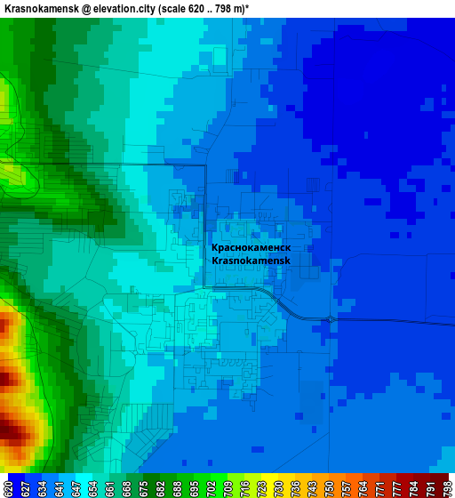
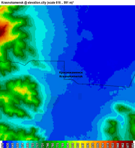
Below is the Elevation map of Krasnokamensk, which displays elevation range with different colors. Scale of the first map is from 620 to 798 m (2034 to 2618 ft) with average elevation of 648.7 meters (=2128 ft) [note 1]
These maps also provides idea of topography and contour of this city, they are displayed at different zoom levels. More info about maps, scale and edge coordinates you can find below images.
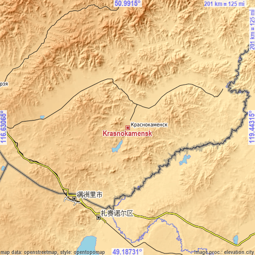
| \ | Map #1 | Map #2 | Topo.Map |
| Scale [m] | 620..798 m | 616..991 m | × |
| Scale [ft] | 2034..2618 ft | 2021..3251 ft | × |
| Average | 648.7 m = 2128 ft | 674 m = 2211 ft | × |
| Width | 6.27 km = 3.9 mi | 12.54 km = 7.8 mi | 200.6 km = 124.6 mi |
| Height | 6.27 km = 3.9 mi | 12.54 km = 7.8 mi | 200.6 km = 124.6 mi |
| ↑Max Latitude | 50.126082° | 50.154247° | 50.9915° |
| Latitude at center | 50.0979° | 50.0979° | 50.0979° |
| ↓Min Latitude | 50.069702° | 50.041487° | 49.18731° |
| ← Min Longitude | 117.992955° | 117.949009° | 116.63065° |
| Longitude center | 118.0369° | 118.0369° | 118.0369° |
| →Max Longitude | 118.080845° | 118.124791° | 119.44315° |
Nearby cities:
Cities around Krasnokamensk sort by population:
• Borzya elevation 687 m
112.7 km,  286°
286°
• Zabaykal’sk 687 m
71.2 km,  225°
225°
• Priargunsk 522 m
81.5 km,  68°
68°
• Dauriya 677 m
85.6 km,  257°
257°
• Kalga 628 m
110.4 km,  33°
33°
• Nerchinskiy Zavod 606 m
174.6 km,  39°
39°
• Kalanguy 784 m
148.2 km,  313°
313°
• Aleksandrovskiy Zavod 795 m
92.3 km,  355°
355°
• Klichka 751 m
38.8 km, 355°
• Gazimurskiy Zavod 680 m
163.3 km,  7°
7°
• Vershino-Shakhtaminskiy 978 m
134.1 km, 355°
• Kadaya 625 m
128.5 km, 43°
Multilingual:
 En español:
Krasnokamensk elevación 642 m.
 En France:
Krasnokamensk élévation 642 m.
 Auf Deutsch:
Krasnokamensk höhe über dem Meeresspiegel ist 642 m.

Sources and notes:
- [note 1] Map square and city borders are not equal. Map elevation data is calculated only from area inside that square.
- [src 1] Elevation data from geonames database provided with same terms of usage.
- [src 2] The elevation map of Krasnokamensk is generated using elevation data from NASA's 3 arcsec (90m) resolution SRTM data.
- [src 3] Base (background) map © OpenStreetMap contributors tiles are generated by Geofabrik and OpenTopoMap.
Copyright & License:
This Krasnokamensk Elevation Map is licensed under CC BY-SA. You may reuse any part from this page, if you give a proper credit by linking to this URL:
 More info on terms of use page.