Sergeyevka elevation
Sergeyevka (Primorskiy (Maritime) Kray), Russia elevation is 140 meters and Sergeyevka elevation in feet is 459 ft above sea level [src 1]. Sergeyevka is a populated place (feature code) with elevation that is 59 meters (194 ft) smaller than average city elevation in Russia.
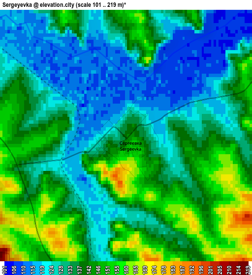
Below is the Elevation map of Sergeyevka, which displays elevation range with different colors. Scale of the first map is from 101 to 219 m (331 to 719 ft) with average elevation of 135.4 meters (=444 ft) [note 1]
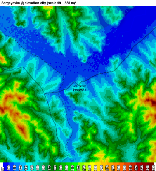
These maps also provides idea of topography and contour of this city, they are displayed at different zoom levels. More info about maps, scale and edge coordinates you can find below images.
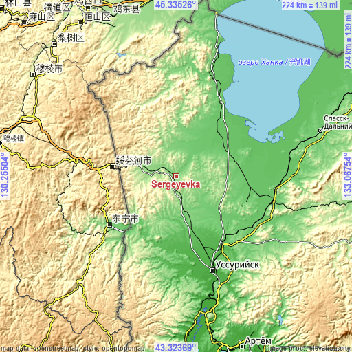
| \ | Map #1 | Map #2 | Topo.Map |
| Scale [m] | 101..219 m | 99..358 m | × |
| Scale [ft] | 331..719 ft | 325..1175 ft | × |
| Average | 135.4 m = 444 ft | 162.7 m = 534 ft | × |
| Width | 6.99 km = 4.3 mi | 13.98 km = 8.7 mi | 223.7 km = 139 mi |
| Height | 6.99 km = 4.3 mi | 13.98 km = 8.7 mi | 223.7 km = 139 mi |
| ↑Max Latitude | 44.369523° | 44.400928° | 45.33526° |
| Latitude at center | 44.3381° | 44.3381° | 44.3381° |
| ↓Min Latitude | 44.306661° | 44.275204° | 43.32369° |
| ← Min Longitude | 131.617345° | 131.573399° | 130.25504° |
| Longitude center | 131.66129° | 131.66129° | 131.66129° |
| →Max Longitude | 131.705235° | 131.749181° | 133.06754° |
Nearby cities:
Cities around Sergeyevka sort by population:
• Pogranichnyy elevation 168 m
23.9 km,  289°
289°
• Kamen’-Rybolov 95 m
54.6 km,  33°
33°
• Khorol’ 110 m
34.4 km,  73°
73°
• Pokrovka 47 m
42.8 km,  182°
182°
• Yaroslavskiy 121 m
48.2 km,  110°
110°
• Mikhaylovka 40 m
52.9 km,  148°
148°
• Novoshakhtinskiy 110 m
53.1 km,  130°
130°
• Vozdvizhenka 33 m
54.3 km,  155°
155°
• Lipovtsy 160 m
16.1 km, 162°
• Blagodatnoye 112 m
34.2 km,  92°
92°
• Zharikovo 119 m
28.3 km,  10°
10°
• Luchki 89 m
48 km,  96°
96°
Multilingual:
 En español:
Sergeyevka elevación 140 m.
 En France:
Sergeyevka élévation 140 m.
 Auf Deutsch:
Sergeyevka höhe über dem Meeresspiegel ist 140 m.

Sources and notes:
- [note 1] Map square and city borders are not equal. Map elevation data is calculated only from area inside that square.
- [src 1] Elevation data from geonames database provided with same terms of usage.
- [src 2] The elevation map of Sergeyevka is generated using elevation data from NASA's 3 arcsec (90m) resolution SRTM data.
- [src 3] Base (background) map © OpenStreetMap contributors tiles are generated by Geofabrik and OpenTopoMap.
Copyright & License:
This Sergeyevka Elevation Map is licensed under CC BY-SA. You may reuse any part from this page, if you give a proper credit by linking to this URL:
 More info on terms of use page.