Mukhen elevation
Mukhen (Khabarovsk), Russia elevation is 86 meters and Mukhen elevation in feet is 282 ft above sea level [src 1]. Mukhen is a populated place (feature code) with elevation that is 113 meters (371 ft) smaller than average city elevation in Russia.
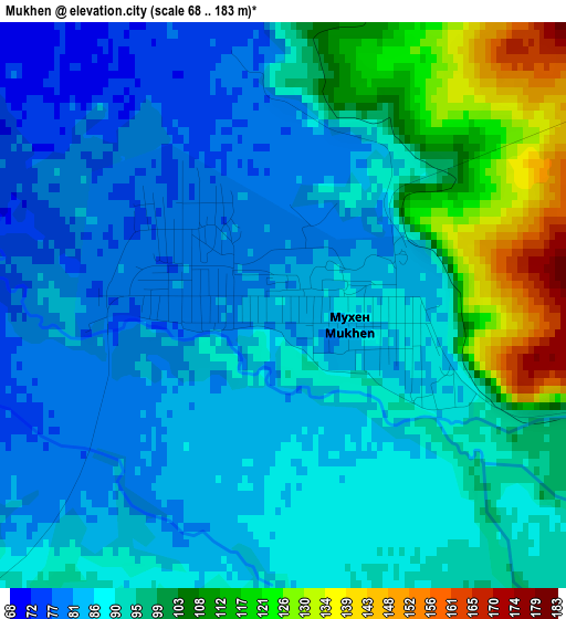
Below is the Elevation map of Mukhen, which displays elevation range with different colors. Scale of the first map is from 68 to 183 m (223 to 600 ft) with average elevation of 92.4 meters (=303 ft) [note 1]
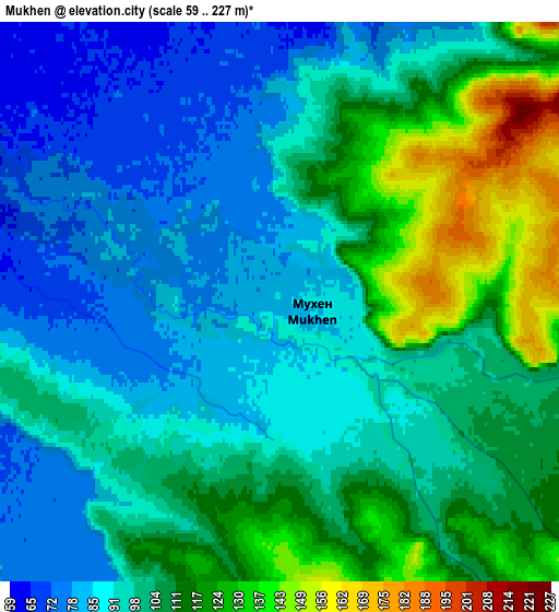
These maps also provides idea of topography and contour of this city, they are displayed at different zoom levels. More info about maps, scale and edge coordinates you can find below images.
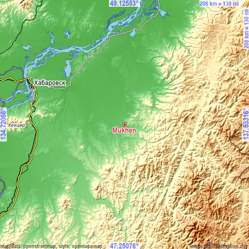
| \ | Map #1 | Map #2 | Topo.Map |
| Scale [m] | 68..183 m | 59..227 m | × |
| Scale [ft] | 223..600 ft | 194..745 ft | × |
| Average | 92.4 m = 303 ft | 100.7 m = 330 ft | × |
| Width | 6.51 km = 4 mi | 13.03 km = 8.1 mi | 208.5 km = 129.6 mi |
| Height | 6.51 km = 4 mi | 13.03 km = 8.1 mi | 208.4 km = 129.5 mi |
| ↑Max Latitude | 48.226004° | 48.255272° | 49.12553° |
| Latitude at center | 48.19672° | 48.19672° | 48.19672° |
| ↓Min Latitude | 48.167419° | 48.138101° | 47.25076° |
| ← Min Longitude | 136.082965° | 136.039019° | 134.72066° |
| Longitude center | 136.12691° | 136.12691° | 136.12691° |
| →Max Longitude | 136.170855° | 136.214801° | 137.53316° |
Nearby cities:
Cities around Mukhen sort by population:
• Khabarovsk elevation 76 m
83.4 km,  292°
292°
• Khabarovsk Vtoroy 59 m
78.2 km, 290°
• Vyazemskiy 73 m
125.8 km,  234°
234°
• Khor 59 m
94.3 km,  248°
248°
• Nekrasovka 82 m
68.4 km,  284°
284°
• Knyaze-Volkonskoye 52 m
57.9 km,  301°
301°
• Smidovich 51 m
176.8 km, 284°
• Korfovskiy 113 m
79.1 km,  272°
272°
• Topolëvo 65 m
78.1 km, 295°
• Priamurskiy 43 m
97.6 km, 292°
• Litovko 71 m
135.2 km,  328°
328°
• Volochayevka Vtoraya 46 m
121.3 km, 289°
Multilingual:
 En español:
Mukhen elevación 86 m.
 En France:
Mukhen élévation 86 m.


Sources and notes:
- [note 1] Map square and city borders are not equal. Map elevation data is calculated only from area inside that square.
- [src 1] Elevation data from geonames database provided with same terms of usage.
- [src 2] The elevation map of Mukhen is generated using elevation data from NASA's 3 arcsec (90m) resolution SRTM data.
- [src 3] Base (background) map © OpenStreetMap contributors tiles are generated by Geofabrik and OpenTopoMap.
Copyright & License:
This Mukhen Elevation Map is licensed under CC BY-SA. You may reuse any part from this page, if you give a proper credit by linking to this URL:
 More info on terms of use page.