Neryungri elevation
Neryungri (Sakha), Russia elevation is 749 meters and Neryungri elevation in feet is 2457 ft above sea level [src 1]. Neryungri is a populated place (feature code) with elevation that is 550 meters (1804 ft) bigger than average city elevation in Russia.
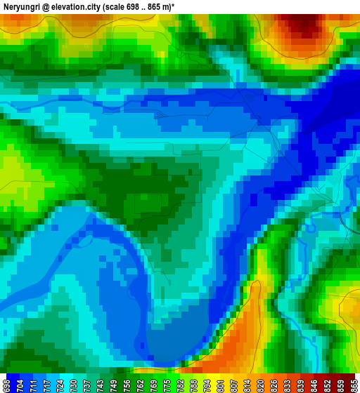
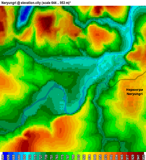
Below is the Elevation map of Neryungri, which displays elevation range with different colors. Scale of the first map is from 698 to 865 m (2290 to 2838 ft) with average elevation of 744.6 meters (=2443 ft) [note 1]
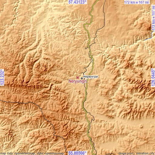
These maps also provides idea of topography and contour of this city, they are displayed at different zoom levels. More info about maps, scale and edge coordinates you can find below images.
| \ | Map #1 | Map #2 | Topo.Map |
| Scale [m] | 698..865 m | 644..953 m | × |
| Scale [ft] | 2290..2838 ft | 2113..3127 ft | × |
| Average | 744.6 m = 2443 ft | 789 m = 2589 ft | × |
| Width | 5.37 km = 3.3 mi | 10.74 km = 6.7 mi | 171.9 km = 106.8 mi |
| Height | 5.37 km = 3.3 mi | 10.74 km = 6.7 mi | 171.8 km = 106.8 mi |
| ↑Max Latitude | 56.690511° | 56.714636° | 57.43123° |
| Latitude at center | 56.66637° | 56.66637° | 56.66637° |
| ↓Min Latitude | 56.642214° | 56.618042° | 55.88566° |
| ← Min Longitude | 124.594305° | 124.550359° | 123.232° |
| Longitude center | 124.63825° | 124.63825° | 124.63825° |
| →Max Longitude | 124.682195° | 124.726141° | 126.0445° |
Nearby cities:
Cities around Neryungri sort by population:
• Tynda elevation 547 m
168 km,  178°
178°
• Aldan 655 m
220.8 km,  11°
11°
• Chul’man 716 m
26 km,  39°
39°
• Tommot 283 m
272.9 km,  21°
21°
• Nizhniy Kuranakh 370 m
245.6 km, 12°
• Berkakit 812 m
13.3 km,  140°
140°
• Serebryanyy Bor 856 m
12.2 km,  87°
87°
• Solovjevsk 518 m
270.8 km, 182°
• Never 453 m
300.3 km,  185°
185°
• Leninskiy 611 m
217.1 km, 12°
• Lebedinyy 810 m
208.9 km, 14°
• Takhtamygda 411 m
291.6 km, 192°
Multilingual:
 En español:
Neryungri elevación 749 m.
 En France:
Neryungri élévation 749 m.
 Auf Deutsch:
Neryungri höhe über dem Meeresspiegel ist 749 m.

Sources and notes:
- [note 1] Map square and city borders are not equal. Map elevation data is calculated only from area inside that square.
- [src 1] Elevation data from geonames database provided with same terms of usage.
- [src 2] The elevation map of Neryungri is generated using elevation data from NASA's 3 arcsec (90m) resolution SRTM data.
- [src 3] Base (background) map © OpenStreetMap contributors tiles are generated by Geofabrik and OpenTopoMap.
Copyright & License:
This Neryungri Elevation Map is licensed under CC BY-SA. You may reuse any part from this page, if you give a proper credit by linking to this URL:
 More info on terms of use page.