Pervomayskiy elevation
Pervomayskiy (Transbaikal Territory), Russia elevation is 666 meters and Pervomayskiy elevation in feet is 2185 ft above sea level [src 1]. Pervomayskiy is a populated place (feature code) with elevation that is 467 meters (1532 ft) bigger than average city elevation in Russia.
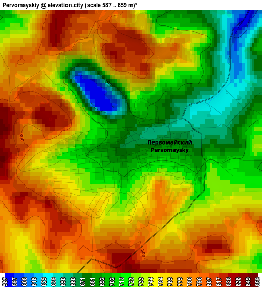
Below is the Elevation map of Pervomayskiy, which displays elevation range with different colors. Scale of the first map is from 587 to 859 m (1926 to 2818 ft) with average elevation of 742.4 meters (=2436 ft) [note 1]
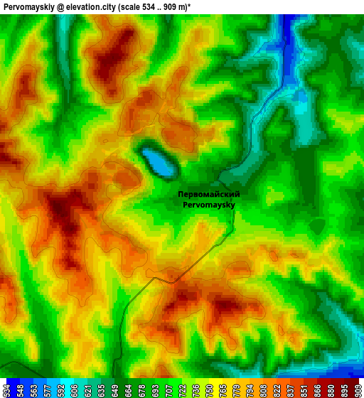
These maps also provides idea of topography and contour of this city, they are displayed at different zoom levels. More info about maps, scale and edge coordinates you can find below images.
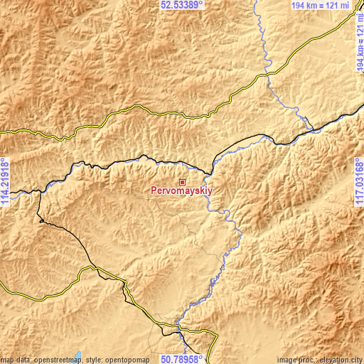
| \ | Map #1 | Map #2 | Topo.Map |
| Scale [m] | 587..859 m | 534..909 m | × |
| Scale [ft] | 1926..2818 ft | 1752..2982 ft | × |
| Average | 742.4 m = 2436 ft | 731.2 m = 2399 ft | × |
| Width | 6.06 km = 3.8 mi | 12.12 km = 7.5 mi | 193.9 km = 120.5 mi |
| Height | 6.06 km = 3.8 mi | 12.12 km = 7.5 mi | 193.9 km = 120.5 mi |
| ↑Max Latitude | 51.697376° | 51.724606° | 52.53389° |
| Latitude at center | 51.67013° | 51.67013° | 51.67013° |
| ↓Min Latitude | 51.642867° | 51.615588° | 50.78958° |
| ← Min Longitude | 115.581485° | 115.537539° | 114.21918° |
| Longitude center | 115.62543° | 115.62543° | 115.62543° |
| →Max Longitude | 115.669375° | 115.713321° | 117.03168° |
Nearby cities:
Cities around Pervomayskiy sort by population:
• Nerchinsk elevation 494 m
74.5 km,  62°
62°
• Shilka 492 m
34.5 km,  54°
54°
• Baley 640 m
70.3 km,  98°
98°
• Karymskoye 594 m
88.2 km,  266°
266°
• Mogoytuy 650 m
65.3 km,  228°
228°
• Olovyannaya 622 m
80.2 km,  182°
182°
• Vershino-Darasunskiy 842 m
77.7 km,  355°
355°
• Novoorlovsk 748 m
90.9 km,  223°
223°
• Kalanguy 784 m
95.4 km,  139°
139°
• Kholbon 482 m
49.1 km, 61°
• Orlovskiy 805 m
89.7 km, 217°
• Priiskovyy 521 m
75.2 km,  67°
67°
Multilingual:
 En español:
Pervomayskiy elevación 666 m.
 En France:
Pervomayskiy élévation 666 m.
 Auf Deutsch:
Pervomayskiy höhe über dem Meeresspiegel ist 666 m.

Sources and notes:
- [note 1] Map square and city borders are not equal. Map elevation data is calculated only from area inside that square.
- [src 1] Elevation data from geonames database provided with same terms of usage.
- [src 2] The elevation map of Pervomayskiy is generated using elevation data from NASA's 3 arcsec (90m) resolution SRTM data.
- [src 3] Base (background) map © OpenStreetMap contributors tiles are generated by Geofabrik and OpenTopoMap.
Copyright & License:
This Pervomayskiy Elevation Map is licensed under CC BY-SA. You may reuse any part from this page, if you give a proper credit by linking to this URL:
 More info on terms of use page.