Shestakovo elevation
Shestakovo (Irkutsk Oblast), Russia elevation is 341 meters and Shestakovo elevation in feet is 1119 ft above sea level [src 1]. Shestakovo is a populated place (feature code) with elevation that is 142 meters (466 ft) bigger than average city elevation in Russia.
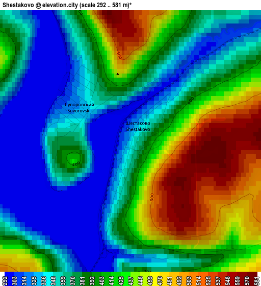
Below is the Elevation map of Shestakovo, which displays elevation range with different colors. Scale of the first map is from 292 to 581 m (958 to 1906 ft) with average elevation of 391.2 meters (=1283 ft) [note 1]
These maps also provides idea of topography and contour of this city, they are displayed at different zoom levels. More info about maps, scale and edge coordinates you can find below images.
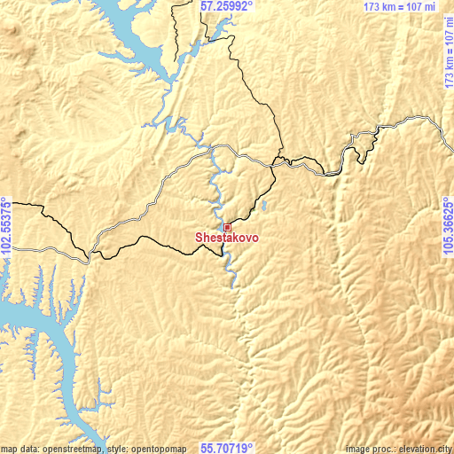
| \ | Map #1 | Topo.Map |
| Scale [m] | 292..581 m | × |
| Scale [ft] | 958..1906 ft | × |
| Average | 391.2 m = 1283 ft | × |
| Width | 5.39 km = 3.3 mi | 172.6 km = 107.2 mi |
| Height | 5.4 km = 3.4 mi | 172.6 km = 107.2 mi |
| ↑Max Latitude | 56.515753° | 57.25992° |
| Latitude at center | 56.4915° | 56.4915° |
| ↓Min Latitude | 56.467232° | 55.70719° |
| ← Min Longitude | 103.916055° | 102.55375° |
| Longitude center | 103.96° | 103.96° |
| →Max Longitude | 104.003945° | 105.36625° |
Nearby cities:
Cities around Shestakovo sort by population:
• Bratsk elevation 443 m
150.1 km,  254°
254°
• Ust’-Kut 312 m
115.5 km,  73°
73°
• Zheleznogorsk-Ilimskiy 449 m
13.7 km,  46°
46°
• Vikhorevka 375 m
176.5 km,  256°
256°
• Novaya Igirma 312 m
71.4 km,  357°
357°
• Zheleznodorozhnyy 348 m
172.6 km,  335°
335°
• Rudnogorsk 427 m
86.8 km,  351°
351°
• Yantal’ 373 m
88.4 km,  63°
63°
• Khrebtovaya 579 m
29.5 km,  36°
36°
• Vidim 439 m
53 km, 260°
• Zvëzdnyy 344 m
156.8 km,  79°
79°
• Bereznyaki 314 m
54.5 km, 335°
Multilingual:
 En español:
Shestakovo elevación 341 m.
 En France:
Shestakovo élévation 341 m.
 Auf Deutsch:
Shestakovo höhe über dem Meeresspiegel ist 341 m.

Sources and notes:
- [note 1] Map square and city borders are not equal. Map elevation data is calculated only from area inside that square.
- [src 1] Elevation data from geonames database provided with same terms of usage.
- [src 2] The elevation map of Shestakovo is generated using elevation data from NASA's 3 arcsec (90m) resolution SRTM data.
- [src 3] Base (background) map © OpenStreetMap contributors tiles are generated by Geofabrik and OpenTopoMap.
Copyright & License:
This Shestakovo Elevation Map is licensed under CC BY-SA. You may reuse any part from this page, if you give a proper credit by linking to this URL:
 More info on terms of use page.