Alibunar elevation
Alibunar (Vojvodina, South Banat), Serbia elevation is 84 meters and Alibunar elevation in feet is 276 ft above sea level [src 1]. Alibunar is a seat of a third-order administrative division (feature code) with elevation that is 83 meters (272 ft) smaller than average city elevation in Serbia.
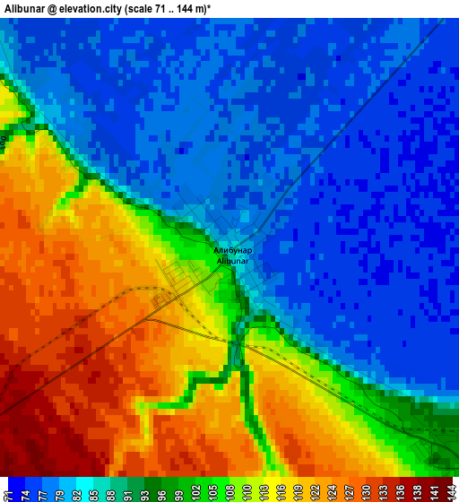
Below is the Elevation map of Alibunar, which displays elevation range with different colors. Scale of the first map is from 71 to 144 m (233 to 472 ft) with average elevation of 96.3 meters (=316 ft) [note 1]
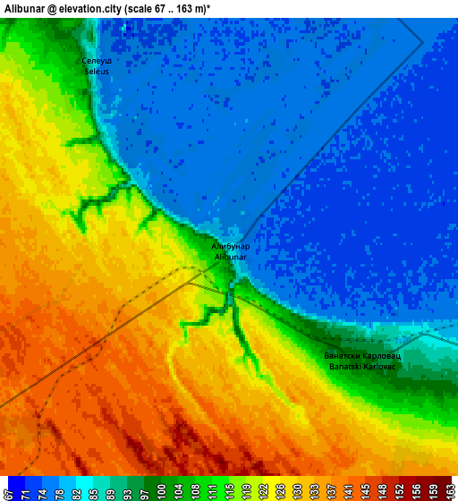
These maps also provides idea of topography and contour of this city, they are displayed at different zoom levels. More info about maps, scale and edge coordinates you can find below images.
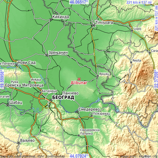
| \ | Map #1 | Map #2 | Topo.Map |
| Scale [m] | 71..144 m | 67..163 m | × |
| Scale [ft] | 233..472 ft | 220..535 ft | × |
| Average | 96.3 m = 316 ft | 104.3 m = 342 ft | × |
| Width | 6.9 km = 4.3 mi | 13.8 km = 8.6 mi | 220.8 km = 137.2 mi |
| Height | 6.9 km = 4.3 mi | 13.8 km = 8.6 mi | 220.8 km = 137.2 mi |
| ↑Max Latitude | 45.111852° | 45.142857° | 46.06517° |
| Latitude at center | 45.08083° | 45.08083° | 45.08083° |
| ↓Min Latitude | 45.049791° | 45.018736° | 44.07924° |
| ← Min Longitude | 20.921885° | 20.877939° | 19.55958° |
| Longitude center | 20.96583° | 20.96583° | 20.96583° |
| →Max Longitude | 21.009775° | 21.053721° | 22.37208° |
Nearby cities:
Cities around Alibunar sort by population:
• Banatski Karlovac elevation 97 m
5.4 km,  130°
130°
• Vladimirovac 137 m
9.6 km,  234°
234°
• Uljma 87 m
15.4 km,  106°
106°
• Lokve 77 m
9.4 km,  32°
32°
• Ilandža 84 m
10.4 km,  339°
339°
• Dobrica 80 m
17.3 km,  328°
328°
• Nikolinci 87 m
8.5 km, 111°
• Seleuš 80 m
6.6 km,  322°
322°
• Jermenovci 78 m
13.3 km, 28°
• Janošik 75 m
10.6 km,  17°
17°
• Kozjak 87 m
13.9 km, 324°
• Barice 77 m
14.5 km,  39°
39°
Multilingual:
 En español:
Alibunar elevación 84 m.
 En France:
Alibunar élévation 84 m.


Sources and notes:
- [note 1] Map square and city borders are not equal. Map elevation data is calculated only from area inside that square.
- [src 1] Elevation data from geonames database provided with same terms of usage.
- [src 2] The elevation map of Alibunar is generated using elevation data from NASA's 3 arcsec (90m) resolution SRTM data.
- [src 3] Base (background) map © OpenStreetMap contributors tiles are generated by Geofabrik and OpenTopoMap.
Copyright & License:
This Alibunar Elevation Map is licensed under CC BY-SA. You may reuse any part from this page, if you give a proper credit by linking to this URL:
 More info on terms of use page.