Niš elevation
Niš (Central Serbia, Nišava), Serbia elevation is 194 meters and Niš elevation in feet is 636 ft above sea level [src 1]. Niš is a seat of a second-order administrative division (feature code) with elevation that is 27 meters (89 ft) bigger than average city elevation in Serbia.
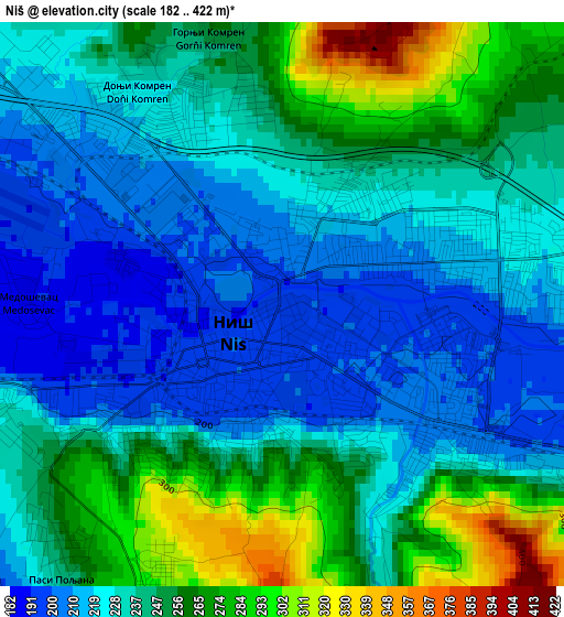
Below is the Elevation map of Niš, which displays elevation range with different colors. Scale of the first map is from 182 to 422 m (597 to 1385 ft) with average elevation of 239 meters (=784 ft) [note 1]
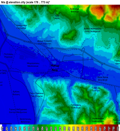
These maps also provides idea of topography and contour of this city, they are displayed at different zoom levels. More info about maps, scale and edge coordinates you can find below images.
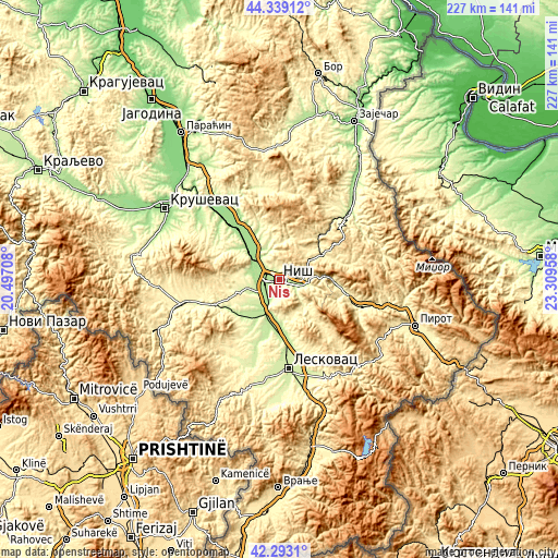
| \ | Map #1 | Map #2 | Topo.Map |
| Scale [m] | 182..422 m | 178..773 m | × |
| Scale [ft] | 597..1385 ft | 584..2536 ft | × |
| Average | 239 m = 784 ft | 276.8 m = 908 ft | × |
| Width | 7.11 km = 4.4 mi | 14.22 km = 8.8 mi | 227.5 km = 141.4 mi |
| Height | 7.11 km = 4.4 mi | 14.22 km = 8.8 mi | 227.5 km = 141.4 mi |
| ↑Max Latitude | 43.356681° | 43.388625° | 44.33912° |
| Latitude at center | 43.32472° | 43.32472° | 43.32472° |
| ↓Min Latitude | 43.292742° | 43.260748° | 42.2931° |
| ← Min Longitude | 21.859385° | 21.815439° | 20.49708° |
| Longitude center | 21.90333° | 21.90333° | 21.90333° |
| →Max Longitude | 21.947275° | 21.991221° | 23.30958° |
Nearby cities:
Cities around Niš sort by population:
• Leskovac elevation 230 m
36.5 km,  174°
174°
• Prokuplje 259 m
27.4 km,  248°
248°
• Bojnik 259 m
37.8 km,  203°
203°
• Soko Banja 310 m
35.5 km,  355°
355°
• Bela Palanka 292 m
35.1 km,  109°
109°
• Aleksinac 169 m
28.8 km,  326°
326°
• Žitorađa 216 m
21.5 km,  225°
225°
• Svrljig 376 m
20.2 km,  60°
60°
• Merošina 244 m
15.5 km, 252°
• Gadžin Han 271 m
15.4 km,  137°
137°
• Doljevac 199 m
15.2 km, 202°
• Niška Banja 234 m
8.9 km, 111°
Multilingual:
 En español:
Niš elevación 194 m.
 En France:
Niš élévation 194 m.


Sources and notes:
- [note 1] Map square and city borders are not equal. Map elevation data is calculated only from area inside that square.
- [src 1] Elevation data from geonames database provided with same terms of usage.
- [src 2] The elevation map of Niš is generated using elevation data from NASA's 3 arcsec (90m) resolution SRTM data.
- [src 3] Base (background) map © OpenStreetMap contributors tiles are generated by Geofabrik and OpenTopoMap.
Copyright & License:
This Niš Elevation Map is licensed under CC BY-SA. You may reuse any part from this page, if you give a proper credit by linking to this URL:
 More info on terms of use page.