Uzdin elevation
Uzdin (Vojvodina, South Banat), Serbia elevation is 77 meters and Uzdin elevation in feet is 253 ft above sea level [src 1]. Uzdin is a populated place (feature code) with elevation that is 90 meters (295 ft) smaller than average city elevation in Serbia.
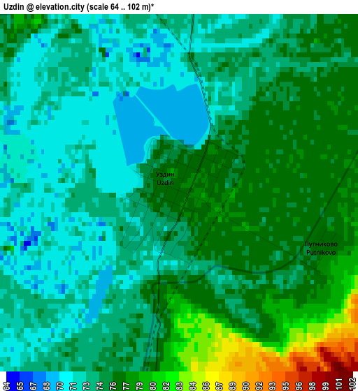
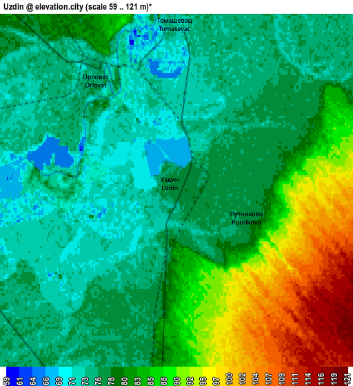
Below is the Elevation map of Uzdin, which displays elevation range with different colors. Scale of the first map is from 64 to 102 m (210 to 335 ft) with average elevation of 74.7 meters (=245 ft) [note 1]
These maps also provides idea of topography and contour of this city, they are displayed at different zoom levels. More info about maps, scale and edge coordinates you can find below images.
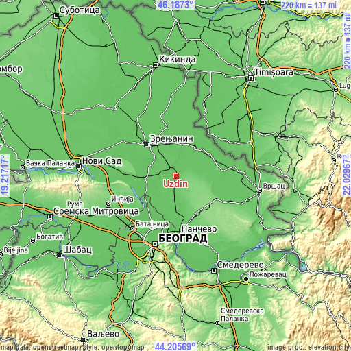
| \ | Map #1 | Map #2 | Topo.Map |
| Scale [m] | 64..102 m | 59..121 m | × |
| Scale [ft] | 210..335 ft | 194..397 ft | × |
| Average | 74.7 m = 245 ft | 80.3 m = 263 ft | × |
| Width | 6.89 km = 4.3 mi | 13.77 km = 8.6 mi | 220.3 km = 136.9 mi |
| Height | 6.89 km = 4.3 mi | 13.77 km = 8.6 mi | 220.3 km = 136.9 mi |
| ↑Max Latitude | 45.236074° | 45.267011° | 46.1873° |
| Latitude at center | 45.20512° | 45.20512° | 45.20512° |
| ↓Min Latitude | 45.174149° | 45.143161° | 44.20569° |
| ← Min Longitude | 20.579475° | 20.535529° | 19.21717° |
| Longitude center | 20.62342° | 20.62342° | 20.62342° |
| →Max Longitude | 20.667365° | 20.711311° | 22.02967° |
Nearby cities:
Cities around Uzdin sort by population:
• Kovačica elevation 78 m
10.4 km,  180°
180°
• Debeljača 78 m
15 km,  186°
186°
• Padina 110 m
12.6 km,  138°
138°
• Botoš 80 m
11.5 km,  4°
4°
• Jarkovac 76 m
12.9 km,  56°
56°
• Sakule 78 m
12.6 km,  238°
238°
• Orlovat 76 m
5.3 km,  320°
320°
• Tomaševac 75 m
7.1 km,  359°
359°
• Stajićevo 78 m
16.3 km,  307°
307°
• Farkaždin 75 m
11.9 km,  262°
262°
• Samoš 96 m
11.8 km,  91°
91°
• Idvor 76 m
8.7 km, 258°
Multilingual:
 En español:
Uzdin elevación 77 m.
 En France:
Uzdin élévation 77 m.


Sources and notes:
- [note 1] Map square and city borders are not equal. Map elevation data is calculated only from area inside that square.
- [src 1] Elevation data from geonames database provided with same terms of usage.
- [src 2] The elevation map of Uzdin is generated using elevation data from NASA's 3 arcsec (90m) resolution SRTM data.
- [src 3] Base (background) map © OpenStreetMap contributors tiles are generated by Geofabrik and OpenTopoMap.
Copyright & License:
This Uzdin Elevation Map is licensed under CC BY-SA. You may reuse any part from this page, if you give a proper credit by linking to this URL:
 More info on terms of use page.