Mačvanska Mitrovica elevation
Mačvanska Mitrovica (Vojvodina, Srem), Serbia elevation is 76 meters and Mačvanska Mitrovica elevation in feet is 249 ft above sea level [src 1]. Mačvanska Mitrovica is a populated place (feature code) with elevation that is 91 meters (299 ft) smaller than average city elevation in Serbia.
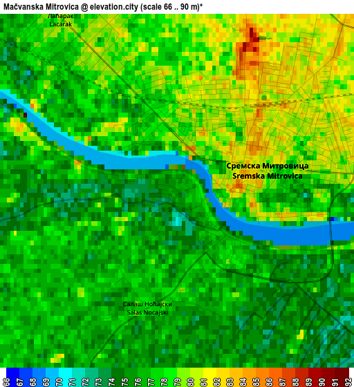
Below is the Elevation map of Mačvanska Mitrovica, which displays elevation range with different colors. Scale of the first map is from 66 to 90 m (217 to 295 ft) with average elevation of 76.7 meters (=252 ft) [note 1]
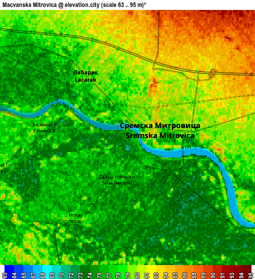
These maps also provides idea of topography and contour of this city, they are displayed at different zoom levels. More info about maps, scale and edge coordinates you can find below images.
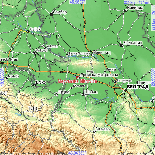
| \ | Map #1 | Map #2 | Topo.Map |
| Scale [m] | 66..90 m | 63..95 m | × |
| Scale [ft] | 217..295 ft | 207..312 ft | × |
| Average | 76.7 m = 252 ft | 78 m = 256 ft | × |
| Width | 6.91 km = 4.3 mi | 13.83 km = 8.6 mi | 221.3 km = 137.5 mi |
| Height | 6.91 km = 4.3 mi | 13.83 km = 8.6 mi | 221.2 km = 137.4 mi |
| ↑Max Latitude | 44.998473° | 45.02954° | 45.9537° |
| Latitude at center | 44.96739° | 44.96739° | 44.96739° |
| ↓Min Latitude | 44.93629° | 44.905173° | 43.96383° |
| ← Min Longitude | 19.549195° | 19.505249° | 18.18689° |
| Longitude center | 19.59314° | 19.59314° | 19.59314° |
| →Max Longitude | 19.637085° | 19.681031° | 20.99939° |
Nearby cities:
Cities around Mačvanska Mitrovica sort by population:
• Sremska Mitrovica elevation 84 m
1.8 km,  56°
56°
• Drenovac 76 m
14.5 km,  140°
140°
• Glušci 80 m
9.3 km,  201°
201°
• Jarak 80 m
13.8 km,  113°
113°
• Šašinci 88 m
11.7 km,  91°
91°
• Salaš Noćajski 77 m
2.3 km,  193°
193°
• Banovo Polje 81 m
13 km,  240°
240°
• Ravnje 80 m
13.7 km,  258°
258°
• Ševarice 78 m
12.3 km,  154°
154°
• Metković 79 m
12.9 km, 196°
• Uzveće 79 m
9.9 km,  175°
175°
• Radenković 81 m
9.2 km, 236°
Multilingual:
 En español:
Mačvanska Mitrovica elevación 76 m.
 En France:
Mačvanska Mitrovica élévation 76 m.
 Auf Deutsch:
Mačvanska Mitrovica höhe über dem Meeresspiegel ist 76 m.
 На русском:
Mačvanska Mitrovica высота над уровнем моря 76 м
Sources and notes:
- [note 1] Map square and city borders are not equal. Map elevation data is calculated only from area inside that square.
- [src 1] Elevation data from geonames database provided with same terms of usage.
- [src 2] The elevation map of Mačvanska Mitrovica is generated using elevation data from NASA's 3 arcsec (90m) resolution SRTM data.
- [src 3] Base (background) map © OpenStreetMap contributors tiles are generated by Geofabrik and OpenTopoMap.
Copyright & License:
This Mačvanska Mitrovica Elevation Map is licensed under CC BY-SA. You may reuse any part from this page, if you give a proper credit by linking to this URL:
 More info on terms of use page.