Sombor elevation
Sombor (Vojvodina, West Bačka), Serbia elevation is 89 meters and Sombor elevation in feet is 292 ft above sea level [src 1]. Sombor is a seat of a second-order administrative division (feature code) with elevation that is 78 meters (256 ft) smaller than average city elevation in Serbia.
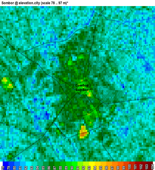
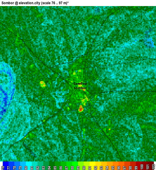
Below is the Elevation map of Sombor, which displays elevation range with different colors. Scale of the first map is from 78 to 97 m (256 to 318 ft) with average elevation of 83.7 meters (=275 ft) [note 1]
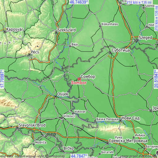
These maps also provides idea of topography and contour of this city, they are displayed at different zoom levels. More info about maps, scale and edge coordinates you can find below images.
| \ | Map #1 | Map #2 | Topo.Map |
| Scale [m] | 78..97 m | 76..97 m | × |
| Scale [ft] | 256..318 ft | 249..318 ft | × |
| Average | 83.7 m = 275 ft | 83.1 m = 273 ft | × |
| Width | 6.82 km = 4.2 mi | 13.63 km = 8.5 mi | 218.1 km = 135.5 mi |
| Height | 6.82 km = 4.2 mi | 13.63 km = 8.5 mi | 218.1 km = 135.5 mi |
| ↑Max Latitude | 45.804813° | 45.835439° | 46.74639° |
| Latitude at center | 45.77417° | 45.77417° | 45.77417° |
| ↓Min Latitude | 45.74351° | 45.712834° | 44.7847° |
| ← Min Longitude | 19.068275° | 19.024329° | 17.70597° |
| Longitude center | 19.11222° | 19.11222° | 19.11222° |
| →Max Longitude | 19.156165° | 19.200111° | 20.51847° |
Nearby cities:
Cities around Sombor sort by population:
• Apatin elevation 90 m
15.4 km,  222°
222°
• Sonta 83 m
20 km,  183°
183°
• Stanišić 95 m
18.8 km,  13°
13°
• Prigrevica 85 m
11 km,  189°
189°
• Riđica 94 m
24.1 km,  358°
358°
• Kupusina 83 m
8.9 km,  242°
242°
• Bogojevo 88 m
27.2 km, 177°
• Doroslovo 85 m
19.5 km,  162°
162°
• Gakovo 88 m
14.6 km,  344°
344°
• Kolut 87 m
19.5 km,  312°
312°
• Bački Breg 88 m
21.6 km,  318°
318°
• Odžaci 89 m
31.9 km, 158°
Multilingual:
 En español:
Sombor elevación 89 m.
 En France:
Sombor élévation 89 m.


Sources and notes:
- [note 1] Map square and city borders are not equal. Map elevation data is calculated only from area inside that square.
- [src 1] Elevation data from geonames database provided with same terms of usage.
- [src 2] The elevation map of Sombor is generated using elevation data from NASA's 3 arcsec (90m) resolution SRTM data.
- [src 3] Base (background) map © OpenStreetMap contributors tiles are generated by Geofabrik and OpenTopoMap.
Copyright & License:
This Sombor Elevation Map is licensed under CC BY-SA. You may reuse any part from this page, if you give a proper credit by linking to this URL:
 More info on terms of use page.