Alunișu elevation
Alunișu (Olt, Comuna Spineni), Romania elevation is 312 meters and Alunișu elevation in feet is 1024 ft above sea level [src 1]. Alunișu is a seat of a second-order administrative division (feature code) with elevation that is 60 meters (197 ft) bigger than average city elevation in Romania.
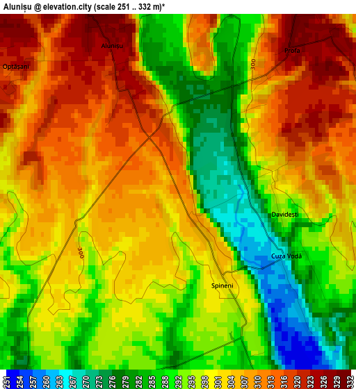
Below is the Elevation map of Alunișu, which displays elevation range with different colors. Scale of the first map is from 251 to 332 m (823 to 1089 ft) with average elevation of 299.4 meters (=982 ft) [note 1]
These maps also provides idea of topography and contour of this city, they are displayed at different zoom levels. More info about maps, scale and edge coordinates you can find below images.
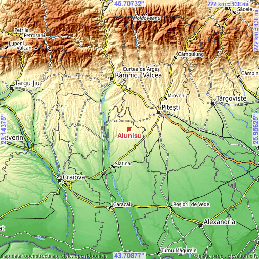
| \ | Map #1 | Topo.Map |
| Scale [m] | 251..332 m | × |
| Scale [ft] | 823..1089 ft | × |
| Average | 299.4 m = 982 ft | × |
| Width | 6.94 km = 4.3 mi | 222.2 km = 138.1 mi |
| Height | 6.94 km = 4.3 mi | 222.2 km = 138.1 mi |
| ↑Max Latitude | 44.747889° | 45.70732° |
| Latitude at center | 44.71667° | 44.71667° |
| ↓Min Latitude | 44.685434° | 43.70877° |
| ← Min Longitude | 24.506055° | 23.14375° |
| Longitude center | 24.55° | 24.55° |
| →Max Longitude | 24.593945° | 25.95625° |
Nearby cities:
Cities around Alunișu sort by population:
• Vedea elevation 298 m
9.1 km,  35°
35°
• Izvoru de Sus 362 m
13.6 km, 35°
• Cungrea 211 m
14.3 km,  247°
247°
• Poboru 279 m
6.8 km,  215°
215°
• Coloneşti 227 m
11.8 km,  128°
128°
• Dobroteasa 332 m
15.1 km,  299°
299°
• Leleasca 347 m
11.8 km,  308°
308°
• Făgeţelu 354 m
7.5 km,  349°
349°
• Tătuleşti 250 m
11.4 km,  144°
144°
• Topana 338 m
11.4 km, 346°
• Bărăștii de Vede 259 m
8.6 km,  90°
90°
• Sâmbureşti 354 m
14 km, 311°
Multilingual:
 En español:
Alunișu elevación 312 m.
 En France:
Alunișu élévation 312 m.


Sources and notes:
- [note 1] Map square and city borders are not equal. Map elevation data is calculated only from area inside that square.
- [src 1] Elevation data from geonames database provided with same terms of usage.
- [src 2] The elevation map of Alunișu is generated using elevation data from NASA's 3 arcsec (90m) resolution SRTM data.
- [src 3] Base (background) map © OpenStreetMap contributors tiles are generated by Geofabrik and OpenTopoMap.
Copyright & License:
This Alunișu Elevation Map is licensed under CC BY-SA. You may reuse any part from this page, if you give a proper credit by linking to this URL:
 More info on terms of use page.