Băile Borșa elevation
Băile Borșa (Maramureş, Oraş Borşa), Romania elevation is 744 meters and Băile Borșa elevation in feet is 2441 ft above sea level [src 1]. Băile Borșa is a populated place (feature code) with elevation that is 492 meters (1614 ft) bigger than average city elevation in Romania.
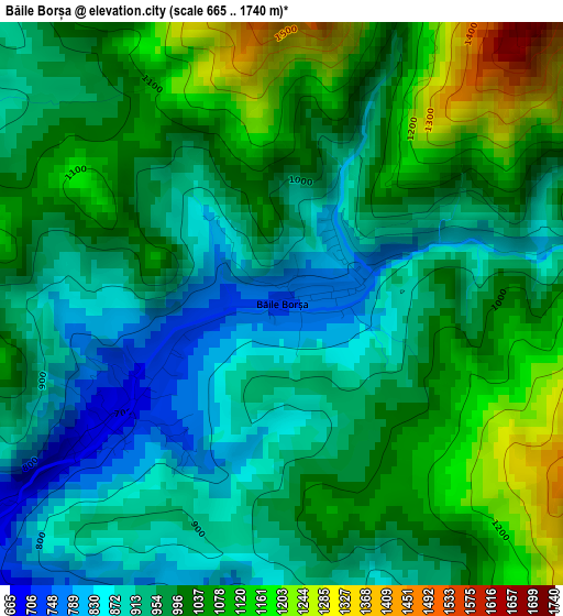
Below is the Elevation map of Băile Borșa, which displays elevation range with different colors. Scale of the first map is from 665 to 1740 m (2182 to 5709 ft) with average elevation of 989 meters (=3245 ft) [note 1]
These maps also provides idea of topography and contour of this city, they are displayed at different zoom levels. More info about maps, scale and edge coordinates you can find below images.
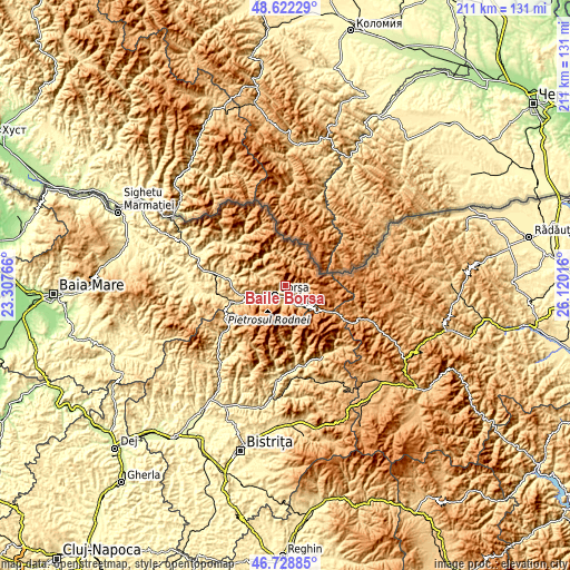
| \ | Map #1 | Topo.Map |
| Scale [m] | 665..1740 m | × |
| Scale [ft] | 2182..5709 ft | × |
| Average | 989 m = 3245 ft | × |
| Width | 6.58 km = 4.1 mi | 210.5 km = 130.8 mi |
| Height | 6.58 km = 4.1 mi | 210.5 km = 130.8 mi |
| ↑Max Latitude | 47.713736° | 48.62229° |
| Latitude at center | 47.68416° | 47.68416° |
| ↓Min Latitude | 47.654567° | 46.72885° |
| ← Min Longitude | 24.669965° | 23.30766° |
| Longitude center | 24.71391° | 24.71391° |
| →Max Longitude | 24.757855° | 26.12016° |
Nearby cities:
Cities around Băile Borșa sort by population:
• Borşa elevation 658 m
5 km,  229°
229°
• Vişeu de Sus 510 m
21.3 km,  279°
279°
• Poienile de sub Munte 634 m
25.6 km,  305°
305°
• Moisei 565 m
13.4 km,  256°
256°
• Vişeu de Jos 457 m
26.4 km, 280°
• Săliştea de Sus 498 m
27.5 km, 262°
• Repedea 506 m
28.7 km, 305°
• Săcel 541 m
21.8 km,  254°
254°
• Vișeu de Mijloc 474 m
23.3 km, 278°
• Șanț 644 m
29.5 km,  151°
151°
• Romuli 697 m
26.9 km, 231°
• Anieș 490 m
30.4 km,  172°
172°
Multilingual:
 En español:
Băile Borșa elevación 744 m.
 En France:
Băile Borșa élévation 744 m.
 Auf Deutsch:
Băile Borșa höhe über dem Meeresspiegel ist 744 m.

Sources and notes:
- [note 1] Map square and city borders are not equal. Map elevation data is calculated only from area inside that square.
- [src 1] Elevation data from geonames database provided with same terms of usage.
- [src 2] The elevation map of Băile Borșa is generated using elevation data from NASA's 3 arcsec (90m) resolution SRTM data.
- [src 3] Base (background) map © OpenStreetMap contributors tiles are generated by Geofabrik and OpenTopoMap.
Copyright & License:
This Băile Borșa Elevation Map is licensed under CC BY-SA. You may reuse any part from this page, if you give a proper credit by linking to this URL:
 More info on terms of use page.