Bala elevation
Bala (Mehedinţi, Comuna Bala), Romania elevation is 232 meters and Bala elevation in feet is 761 ft above sea level [src 1]. Bala is a seat of a second-order administrative division (feature code) with elevation that is 20 meters (66 ft) smaller than average city elevation in Romania.
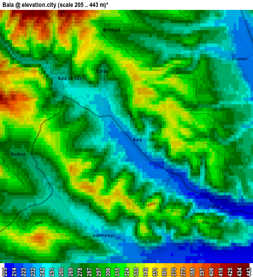
Below is the Elevation map of Bala, which displays elevation range with different colors. Scale of the first map is from 205 to 443 m (673 to 1453 ft) with average elevation of 287.9 meters (=945 ft) [note 1]
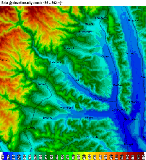
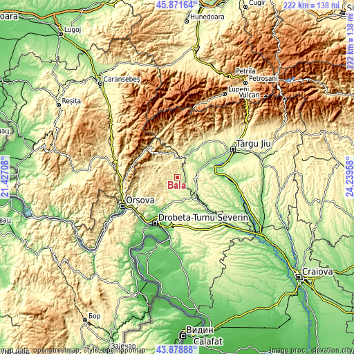
These maps also provides idea of topography and contour of this city, they are displayed at different zoom levels. More info about maps, scale and edge coordinates you can find below images.
| \ | Map #1 | Map #2 | Topo.Map |
| Scale [m] | 205..443 m | 186..592 m | × |
| Scale [ft] | 673..1453 ft | 610..1942 ft | × |
| Average | 287.9 m = 945 ft | 319.6 m = 1049 ft | × |
| Width | 6.92 km = 4.3 mi | 13.85 km = 8.6 mi | 221.6 km = 137.7 mi |
| Height | 6.92 km = 4.3 mi | 13.85 km = 8.6 mi | 221.6 km = 137.7 mi |
| ↑Max Latitude | 44.915019° | 44.94613° | 45.87164° |
| Latitude at center | 44.88389° | 44.88389° | 44.88389° |
| ↓Min Latitude | 44.852745° | 44.821582° | 43.87888° |
| ← Min Longitude | 22.789385° | 22.745439° | 21.42708° |
| Longitude center | 22.83333° | 22.83333° | 22.83333° |
| →Max Longitude | 22.877275° | 22.921221° | 24.23958° |
Nearby cities:
Cities around Bala sort by population:
• Motru elevation 182 m
14.1 km,  129°
129°
• Padeş 274 m
14.8 km,  5°
5°
• Ponoarele 349 m
11.4 km,  331°
331°
• Baia de Aramă 278 m
13 km,  351°
351°
• Glogova 245 m
7.6 km,  49°
49°
• Ciuperceni 186 m
15.4 km,  69°
69°
• Şovarna 275 m
4.7 km,  223°
223°
• Ploștina 205 m
13.9 km,  118°
118°
• Bâlvăneşti 520 m
15.4 km,  231°
231°
• Ilovăț 250 m
9.7 km,  214°
214°
• Cătunele 205 m
6.2 km,  110°
110°
• Şişeşti 217 m
11.8 km,  177°
177°
Multilingual:
 En español:
Bala elevación 232 m.
 En France:
Bala élévation 232 m.


Sources and notes:
- [note 1] Map square and city borders are not equal. Map elevation data is calculated only from area inside that square.
- [src 1] Elevation data from geonames database provided with same terms of usage.
- [src 2] The elevation map of Bala is generated using elevation data from NASA's 3 arcsec (90m) resolution SRTM data.
- [src 3] Base (background) map © OpenStreetMap contributors tiles are generated by Geofabrik and OpenTopoMap.
Copyright & License:
This Bala Elevation Map is licensed under CC BY-SA. You may reuse any part from this page, if you give a proper credit by linking to this URL:
 More info on terms of use page.