Balta Albă elevation
Balta Albă (Buzău, Comuna Balta Albă), Romania elevation is 38 meters and Balta Albă elevation in feet is 125 ft above sea level [src 1]. Balta Albă is a seat of a second-order administrative division (feature code) with elevation that is 214 meters (702 ft) smaller than average city elevation in Romania.
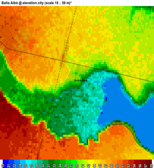
Below is the Elevation map of Balta Albă, which displays elevation range with different colors. Scale of the first map is from 19 to 59 m (62 to 194 ft) with average elevation of 41.1 meters (=135 ft) [note 1]
These maps also provides idea of topography and contour of this city, they are displayed at different zoom levels. More info about maps, scale and edge coordinates you can find below images.
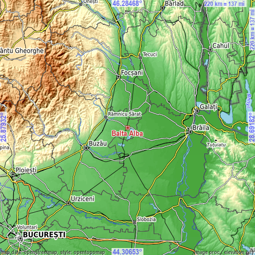
| \ | Map #1 | Topo.Map |
| Scale [m] | 19..59 m | × |
| Scale [ft] | 62..194 ft | × |
| Average | 41.1 m = 135 ft | × |
| Width | 6.87 km = 4.3 mi | 219.9 km = 136.6 mi |
| Height | 6.87 km = 4.3 mi | 219.9 km = 136.6 mi |
| ↑Max Latitude | 45.33513° | 46.28468° |
| Latitude at center | 45.30423° | 45.30423° |
| ↓Min Latitude | 45.273313° | 44.30653° |
| ← Min Longitude | 27.241625° | 25.87932° |
| Longitude center | 27.28557° | 27.28557° |
| →Max Longitude | 27.329515° | 28.69182° |
Nearby cities:
Cities around Balta Albă sort by population:
• Ciorăşti elevation 38 m
14.4 km,  4°
4°
• Galbenu 48 m
13.5 km,  223°
223°
• Ghergheasa 50 m
7.9 km,  238°
238°
• Grădiştea 41 m
8.7 km,  118°
118°
• Boldu 55 m
5.2 km,  308°
308°
• Vâlcelele 36 m
6.7 km,  48°
48°
• Bălăceanu 60 m
11.4 km,  248°
248°
• Amara 44 m
6.2 km,  175°
175°
• Puieștii de Jos 60 m
12.1 km,  334°
334°
• Racoviţa 23 m
12.9 km,  92°
92°
• Sălcioara 65 m
8.5 km,  273°
273°
• Dăscălești 52 m
11.7 km,  346°
346°
Multilingual:
 En español:
Balta Albă elevación 38 m.
 En France:
Balta Albă élévation 38 m.
 Auf Deutsch:
Balta Albă höhe über dem Meeresspiegel ist 38 m.

Sources and notes:
- [note 1] Map square and city borders are not equal. Map elevation data is calculated only from area inside that square.
- [src 1] Elevation data from geonames database provided with same terms of usage.
- [src 2] The elevation map of Balta Albă is generated using elevation data from NASA's 3 arcsec (90m) resolution SRTM data.
- [src 3] Base (background) map © OpenStreetMap contributors tiles are generated by Geofabrik and OpenTopoMap.
Copyright & License:
This Balta Albă Elevation Map is licensed under CC BY-SA. You may reuse any part from this page, if you give a proper credit by linking to this URL:
 More info on terms of use page.