Bancu elevation
Bancu (Harghita, Comuna Ciucsângeorgiu), Romania elevation is 715 meters and Bancu elevation in feet is 2346 ft above sea level [src 1]. Bancu is a populated place (feature code) with elevation that is 463 meters (1519 ft) bigger than average city elevation in Romania.
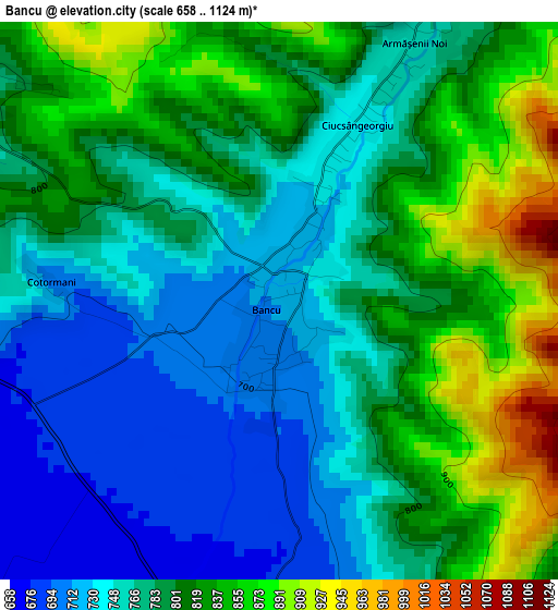
Below is the Elevation map of Bancu, which displays elevation range with different colors. Scale of the first map is from 658 to 1124 m (2159 to 3688 ft) with average elevation of 789.7 meters (=2591 ft) [note 1]
These maps also provides idea of topography and contour of this city, they are displayed at different zoom levels. More info about maps, scale and edge coordinates you can find below images.
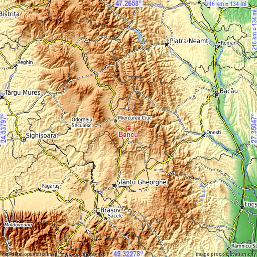
| \ | Map #1 | Topo.Map |
| Scale [m] | 658..1124 m | × |
| Scale [ft] | 2159..3688 ft | × |
| Average | 789.7 m = 2591 ft | × |
| Width | 6.75 km = 4.2 mi | 216 km = 134.2 mi |
| Height | 6.75 km = 4.2 mi | 216 km = 134.2 mi |
| ↑Max Latitude | 46.333261° | 47.2658° |
| Latitude at center | 46.30291° | 46.30291° |
| ↓Min Latitude | 46.272542° | 45.32278° |
| ← Min Longitude | 25.900275° | 24.53797° |
| Longitude center | 25.94422° | 25.94422° |
| →Max Longitude | 25.988165° | 27.35047° |
Nearby cities:
Cities around Bancu sort by population:
• Miercurea-Ciuc elevation 653 m
12.2 km,  295°
295°
• Sâncrăieni 657 m
8.2 km,  279°
279°
• Ciucsângeorgiu 731 m
1.6 km,  16°
16°
• Sânmartin 671 m
4.1 km,  191°
191°
• Sânsimion 640 m
7.5 km,  218°
218°
• Sântimbru 646 m
7.3 km,  250°
250°
• Tuşnad 638 m
11.9 km,  196°
196°
• Cozmeni 674 m
8.5 km,  181°
181°
• Ciucani 680 m
5.1 km, 177°
• Misentea 769 m
4.6 km,  305°
305°
• Tușnadu Nou 654 m
12.9 km, 199°
• Leliceni 717 m
8.9 km, 303°
Multilingual:
 En español:
Bancu elevación 715 m.
 En France:
Bancu élévation 715 m.


Sources and notes:
- [note 1] Map square and city borders are not equal. Map elevation data is calculated only from area inside that square.
- [src 1] Elevation data from geonames database provided with same terms of usage.
- [src 2] The elevation map of Bancu is generated using elevation data from NASA's 3 arcsec (90m) resolution SRTM data.
- [src 3] Base (background) map © OpenStreetMap contributors tiles are generated by Geofabrik and OpenTopoMap.
Copyright & License:
This Bancu Elevation Map is licensed under CC BY-SA. You may reuse any part from this page, if you give a proper credit by linking to this URL:
 More info on terms of use page.