Bărbuleţu elevation
Bărbuleţu (Dâmboviţa, Comuna Bărbuleţu), Romania elevation is 492 meters and Bărbuleţu elevation in feet is 1614 ft above sea level [src 1]. Bărbuleţu is a seat of a second-order administrative division (feature code) with elevation that is 240 meters (787 ft) bigger than average city elevation in Romania.
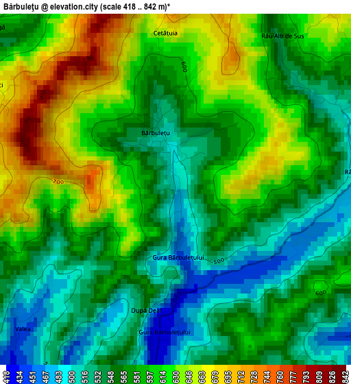
Below is the Elevation map of Bărbuleţu, which displays elevation range with different colors. Scale of the first map is from 418 to 842 m (1371 to 2762 ft) with average elevation of 580.7 meters (=1905 ft) [note 1]
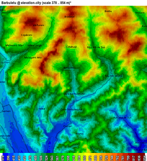
These maps also provides idea of topography and contour of this city, they are displayed at different zoom levels. More info about maps, scale and edge coordinates you can find below images.
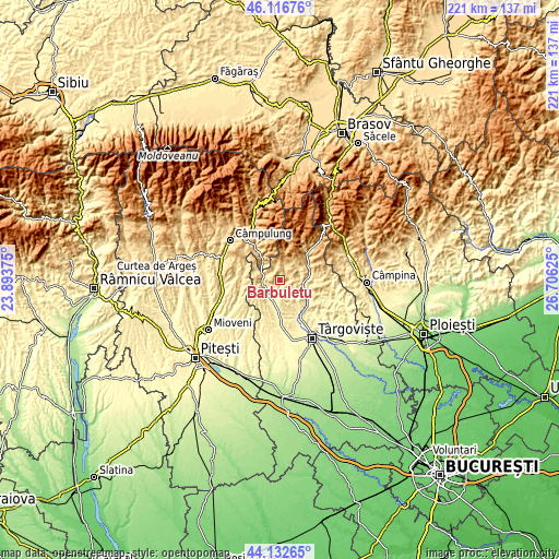
| \ | Map #1 | Map #2 | Topo.Map |
| Scale [m] | 418..842 m | 378..854 m | × |
| Scale [ft] | 1371..2762 ft | 1240..2802 ft | × |
| Average | 580.7 m = 1905 ft | 574 m = 1883 ft | × |
| Width | 6.89 km = 4.3 mi | 13.79 km = 8.6 mi | 220.6 km = 137.1 mi |
| Height | 6.89 km = 4.3 mi | 13.79 km = 8.6 mi | 220.6 km = 137.1 mi |
| ↑Max Latitude | 45.164323° | 45.1953° | 46.11676° |
| Latitude at center | 45.13333° | 45.13333° | 45.13333° |
| ↓Min Latitude | 45.10232° | 45.071293° | 44.13265° |
| ← Min Longitude | 25.256055° | 25.212109° | 23.89375° |
| Longitude center | 25.3° | 25.3° | 25.3° |
| →Max Longitude | 25.343945° | 25.387891° | 26.70625° |
Nearby cities:
Cities around Bărbuleţu sort by population:
• Fieni elevation 486 m
9.2 km,  90°
90°
• Voineşti 396 m
8.4 km,  207°
207°
• Runcu 556 m
8.6 km,  49°
49°
• Vulcana Băi 388 m
8.8 km,  132°
132°
• Malu cu Flori 608 m
8.1 km,  283°
283°
• Pucheni 671 m
5.7 km,  346°
346°
• Vulcana de Sus 432 m
5.8 km, 127°
• Râu Alb de Jos 492 m
3.7 km,  84°
84°
• Gemenea Brătulești 448 m
6 km,  242°
242°
• Pietrari 414 m
4.4 km,  187°
187°
• Bădeni 503 m
8.3 km, 75°
• Cândeşti Vale 442 m
8.6 km,  229°
229°
Multilingual:
 En español:
Bărbuleţu elevación 492 m.
 En France:
Bărbuleţu élévation 492 m.
 Auf Deutsch:
Bărbuleţu höhe über dem Meeresspiegel ist 492 m.

Sources and notes:
- [note 1] Map square and city borders are not equal. Map elevation data is calculated only from area inside that square.
- [src 1] Elevation data from geonames database provided with same terms of usage.
- [src 2] The elevation map of Bărbuleţu is generated using elevation data from NASA's 3 arcsec (90m) resolution SRTM data.
- [src 3] Base (background) map © OpenStreetMap contributors tiles are generated by Geofabrik and OpenTopoMap.
Copyright & License:
This Bărbuleţu Elevation Map is licensed under CC BY-SA. You may reuse any part from this page, if you give a proper credit by linking to this URL:
 More info on terms of use page.